Etwall: Difference between revisions
Created page with "{{Infobox town |name=Etwall |county=Derbyshire |picture=Etwall well dressing 505406 4281dfb7.jpg |picture caption=Well dressing in Etwall |os grid ref=SK268316 |latitude=52.88..." |
No edit summary |
||
| Line 23: | Line 23: | ||
==Geography== | ==Geography== | ||
Etwall is located between the | Etwall is located between the A516, which bypassed the village in February 1992, and the A50 in southern Derbyshire. | ||
The parish church is St Helen's. | The parish church is St Helen's. | ||
| Line 34: | Line 34: | ||
==History== | ==History== | ||
The John Port Grammar School opened in 1956, with the Etwall Secondary School on the same site. They combined as the comprehensive | The John Port Grammar School opened in 1956, with the Etwall Secondary School on the same site. They combined as the comprehensive John Port School in 1965. | ||
==Amenities== | ==Amenities== | ||
Revision as of 23:35, 30 October 2015
| Etwall | |
| Derbyshire | |
|---|---|
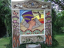
 Well dressing in Etwall | |
| Location | |
| Grid reference: | SK268316 |
| Location: | 52°53’2"N, 1°36’7"W |
| Data | |
| Post town: | Derby |
| Postcode: | DE65 |
| Local Government | |
| Council: | South Derbyshire |
Etwall is a village in Derbyshire, to the southwest of Derby, just north of the A50 dual carriageway between Stoke on Trent and the M1 motorway. The A516 bypassing the village draws a lot of heavy traffic heading for the M1 north. To the south, across the A50, is Hilton. Etwall escapes the clutches of Derby's swollen townscape by just a few miles of green corridor.
Toyota's Burnaston car plant is to the east, which provides employment for many of the villagers. The part of the village that is closely adjacent to the A50, and the Toyota Car factory, is separately named as Etwall Common.
The village's name comes from the Old English Eattan wiele, meaning "Eatta’s spring", after an otherwise unknown Anglo-Saxon chieftain or landowner.
Etwall is famous for its well dressing festival held every May.[1]
Geography
Etwall is located between the A516, which bypassed the village in February 1992, and the A50 in southern Derbyshire.
The parish church is St Helen's.
The village has its own public library, several schools including a state pre-school,[2] state primary,[3] and a large secondary school, John Port School.
A war memorial stands in the shadow of a memorial tree which was planted in the 1800s.
There is a Buddhist centre at Ashe Hall established by Kelsang Gyatso.[4] The Buddhists have also created an independent day school in Etwall.[5]
History
The John Port Grammar School opened in 1956, with the Etwall Secondary School on the same site. They combined as the comprehensive John Port School in 1965.
Amenities
Etwall is an affluent and vibrant village benefiting from several amenities including a post office,, two village stores,, a restaurant (Blenheim House),[6] and local shops and medical practices.
The village has a large village hall.[7] It has two historic pubs on its Main Street: the Spread Eagle is the oldest and the Hawk and Buckle dates from around 1800. There is also the more modern Seven Wells and a Bar inside Blenhiem House.
Sport and leisure
- Cricket: Etwall Cricket Club
- Football: Etwall Rangers
- Swimming: Etwall Eagles Swimming Club
- Tennis: Etwall Tennis Club
- Futsal: Team FS Derby
The King George V Playing Field hosts Etwall Rangers (sponsored by the Hawk and Buckle) on Sunday mornings. Thre is a leisure centre in the village too.
The village has excellent walking and cycling links with three national cycle network routes meeting in the village; Route 54, Route 549 and Route 68.
Outside links
| ("Wikimedia Commons" has material about Etwall) |
- Etwall.org.uk
- Amateur Weather Station based in Etwall
- History of the village
- Information with pictures
- 1849 Tithe Map & Apportionment of Etwall
- Sustrans National Cycle Network routes:
References
- ↑ Etwall Well Dressing Association
- ↑ "Etwall Pre-School". http://www.etwallpreschool.org.uk. Retrieved 12 August 2013.
- ↑ "Etwall Primary School". http://www.etwall.derbyshire.sch.uk. Retrieved 12 August 2013.
- ↑ "Tara Kadampa Meditation Centre". http://www.tarakmc.org. Retrieved 12 August 2013.
- ↑ "Kadampa Independent Primary School". http://www.derbyshirekadampaprimary.org/. Retrieved 18 January 2014.
- ↑ [http://www.blenheimhouse-etwall.co.uk
- ↑ [http://www.etwall.org.uk/html/frank_wickham_hall.html Frank Wickham Hall
