Hurlford: Difference between revisions
Created page with "{{Infobox town |name=Hurlford |county=Ayrshire |picture=Approaching Hurlford from the west - geograph.org.uk - 170800.jpg |picture caption=Road leading into Hurlford |os grid..." |
No edit summary |
||
| Line 15: | Line 15: | ||
|constituency=Kilmarnock and Loudoun | |constituency=Kilmarnock and Loudoun | ||
}} | }} | ||
'''Hurlford''' is a village in [[Ayrshire]], on the south side of the [[River Irvine]] to the east of [[Kilmarnock]]. To the north across the river | '''Hurlford''' is a village in the parish of [[Riccarton]], [[Ayrshire]], on the south side of the [[River Irvine]] to the east of [[Kilmarnock]]. To the north across the river in the parish of Kilmarnock, is [[Crookedholm]]; the combined locality had a recorded population of 4,968 in 2011. | ||
Hurlford's former names include '''Whirlford''' and '''Hurdleford'''.<ref name="East Ayrshire Council">[http://www.east-ayrshire.gov.uk/content.asp?URL=/crpadmmin/nov97/irvine%20valley%20local%20committee%20-%2024%20september%201997.pdf East Ayrshire Council Minutes, page 217, Item 7]</ref> The village was named Whirlford as a result of a ford crossing the River Irvine east of Hurlford Cross, near Shawhill.<ref name="Kilmarnock Standard">{{cite web|url=http://www.kilmarnockstandard.co.uk/ayrshire-news/latest-news/2007/10/04/john-helps-put-hurlford-history-on-the-world-map-81430-19894925 |title=John helps put Hurlford history on the world map |publisher=Kilmarnock Standard |date=2007-10-04 |accessdate=2012-05-11}}</ref> | Hurlford's former names include '''Whirlford''' and '''Hurdleford'''.<ref name="East Ayrshire Council">[http://www.east-ayrshire.gov.uk/content.asp?URL=/crpadmmin/nov97/irvine%20valley%20local%20committee%20-%2024%20september%201997.pdf East Ayrshire Council Minutes, page 217, Item 7]</ref> The village was named Whirlford as a result of a ford crossing the River Irvine east of Hurlford Cross, near Shawhill.<ref name="Kilmarnock Standard">{{cite web|url=http://www.kilmarnockstandard.co.uk/ayrshire-news/latest-news/2007/10/04/john-helps-put-hurlford-history-on-the-world-map-81430-19894925 |title=John helps put Hurlford history on the world map |publisher=Kilmarnock Standard |date=2007-10-04 |accessdate=2012-05-11}}</ref> | ||
| Line 22: | Line 22: | ||
==Churches== | ==Churches== | ||
Historically | Historically part of [[Riccarton]] parish, the village became an ecclesiastical parish of its own. The [[Church of Scotland]] parish church today is in neighbouring Crookedholm, after Crookedholm's and Hurlford's ecclesiastical parishes were united. | ||
The churches of the village are: | The churches of the village are: | ||
*The Hurlford Kirk, Crookedholm | *The Hurlford Kirk, Crookedholm | ||
*Roman Catholic: | *Roman Catholic: St Paul's | ||
Hurlford Kirk, the former Free Church built in 1857, is part of the [[Church of Scotland]].<ref>{{Cite web|url=http://www.sacredscotland.org.uk/church/hurlford-church|title=Hurlford Church|publisher=Scotland's Churches Scheme|accessdate=2012-05-11}}</ref> | Hurlford Kirk, the former Free Church built in 1857, is part of the [[Church of Scotland]].<ref>{{Cite web|url=http://www.sacredscotland.org.uk/church/hurlford-church|title=Hurlford Church|publisher=Scotland's Churches Scheme|accessdate=2012-05-11}}</ref> | ||
Latest revision as of 17:38, 28 October 2015
| Hurlford | |
| Ayrshire | |
|---|---|
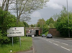
 Road leading into Hurlford | |
| Location | |
| Grid reference: | NS456366 |
| Location: | 55°35’54"N, 4°27’7"W |
| Data | |
| Population: | 4,968 |
| Post town: | Kilmarnock |
| Postcode: | KA1, KA3 |
| Dialling code: | 01560 |
| Local Government | |
| Council: | East Ayrshire |
| Parliamentary constituency: |
Kilmarnock and Loudoun |
Hurlford is a village in the parish of Riccarton, Ayrshire, on the south side of the River Irvine to the east of Kilmarnock. To the north across the river in the parish of Kilmarnock, is Crookedholm; the combined locality had a recorded population of 4,968 in 2011.
Hurlford's former names include Whirlford and Hurdleford.[1] The village was named Whirlford as a result of a ford crossing the River Irvine east of Hurlford Cross, near Shawhill.[2]
The village's Blair Park is home to Hurlford United F.C. and many notable footballers have been trained there.
Churches
Historically part of Riccarton parish, the village became an ecclesiastical parish of its own. The Church of Scotland parish church today is in neighbouring Crookedholm, after Crookedholm's and Hurlford's ecclesiastical parishes were united.
The churches of the village are:
- The Hurlford Kirk, Crookedholm
- Roman Catholic: St Paul's
Hurlford Kirk, the former Free Church built in 1857, is part of the Church of Scotland.[3]
Wo additional churches have been closed and converted into accommodation. The Mauchline Road Church was formerly part of the Unitarian Churches,[2] but now provides luxury housing.[4] The Hurlford Kirk, which was the original parish church built in 1875 has also been converted into a house, having become redundant as a church in 1996 when its congregation merged with that of the Free Church.[5][6]
Economy
The town developed rapidly in the 19th century, following the discovery of coal. Fireclay and ironstone were also worked extensively until production ceased in the 1970s. A poignant reminder of the heyday of the iron and steel industry of Hurlford is the ship's propeller erected at the Cross in the lately redeveloped town centre.[7] Today, industries found in Hurlford include brakepad manufacturing by Eurofriction Limited and whisky production by international company Diageo.
Transport
Hurlford railway station is now closed. However, East Ayrshire Council have recently entered negotiations with First ScotRail to re-introduce passenger rail halts.
Hurlford also used to boast its own tramway system, which connected it to Kilmarnock.
| ("Wikimedia Commons" has material about Hurlford) |
References
- ↑ East Ayrshire Council Minutes, page 217, Item 7
- ↑ 2.0 2.1 "John helps put Hurlford history on the world map". Kilmarnock Standard. 2007-10-04. http://www.kilmarnockstandard.co.uk/ayrshire-news/latest-news/2007/10/04/john-helps-put-hurlford-history-on-the-world-map-81430-19894925. Retrieved 2012-05-11. Cite error: Invalid
<ref>tag; name "Kilmarnock Standard" defined multiple times with different content - ↑ "Hurlford Church". Scotland's Churches Scheme. http://www.sacredscotland.org.uk/church/hurlford-church. Retrieved 2012-05-11.
- ↑ "Hurlford Church : Floor Plans : Lumax homes ltd :". Lumaxhomes.com. http://www.lumaxhomes.com/hurlford/HurlfordChurchFloorplans.html. Retrieved 2012-05-11.
- ↑ Crookedholm Main Road, Former Hurlford Kirk and Manse - British Listed Buildings
- ↑ Davidson, Laura (2008-07-20). "Church conversion was answer to our prayers; Derelict kirk is the perfect family home peek in your pad.". Sunday Mail (Glasgow: Scottish Daily Record & Sunday). http://www.thefreelibrary.com/Church+conversion+was+answer+to+our+prayers%3B+Derelict+kirk+is+the...-a0181591106.
- ↑ "My Area – Hurlford". East Ayrshire Council. http://web.archive.org/web/20110724010806/http://www.east-ayrshire.gov.uk/comser/my%20area/hurlford.asp. Retrieved 2012-05-11.
