Rollright Stones: Difference between revisions
Created page with "right|thumb|350px|Stones in the King's Men circle, amongst the Rollright Stones {{county|Oxfordshire}} The '''Rollri..." |
|||
| Line 24: | Line 24: | ||
*Location map: {{wmap|51.975534|-1.570814|zoom=14}} | *Location map: {{wmap|51.975534|-1.570814|zoom=14}} | ||
The Rollright Stones are located on the contemporary border between the counties of [[Oxfordshire]] and [[Warwickshire]], two-and-a-half miles north-northwest of the town of [[Chipping Norton]], and one-and-three-quarters of a mile west of the smaller village at [[Great Rollright]].<ref name="Lambrick 1">[[#Lam88|Lambrick 1988]]. p. 1.</ref><ref>[[#Bur05|Burl 2005]]. p. 72.</ref> The monuments sit on the scarp of the [[Cotswold Hills]], just as the scarp forms a ridge between the [[River Stour, Warwickshire|Stour valley]] to the north and the Swere valley to the south; geologically, this ridge had been formed from Chipping Norton limestone, itself a variant of the Great Oolite series of Jurassic limestone.<ref name="Lambrick 1"/> | The Rollright Stones are located on the contemporary border between the counties of [[Oxfordshire|Oxford]] and [[Warwickshire|Warwick]], two-and-a-half miles north-northwest of the town of [[Chipping Norton]], and one-and-three-quarters of a mile west of the smaller village at [[Great Rollright]].<ref name="Lambrick 1">[[#Lam88|Lambrick 1988]]. p. 1.</ref><ref>[[#Bur05|Burl 2005]]. p. 72.</ref> The monuments sit on the scarp of the [[Cotswold Hills]], just as the scarp forms a ridge between the [[River Stour, Warwickshire|Stour valley]] to the north and the Swere valley to the south; geologically, this ridge had been formed from Chipping Norton limestone, itself a variant of the Great Oolite series of Jurassic limestone.<ref name="Lambrick 1"/> | ||
==Background== | ==Background== | ||
Latest revision as of 20:44, 28 May 2015
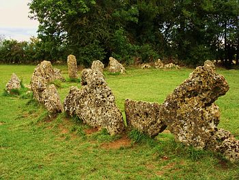
The Rollright Stones are a complex of three Neolithic and Bronze Age megalithic monuments across the border of Oxfordshire with Warwickshire, between the villages of Great Rollright and Little Rollright.
Constructed from local oolitic limestone, the three monuments now known as:
- The King's Men,
- The King Stone and
- The Whispering Knights
Today a road runs through the site, a very old road but positively modern compared with the stones, and the road marks the county border. The King's Men and the Whispering Knights are found on the south side of the road (in Oxfordshire) and the King Stone on the north side (in Warwickshire).
Each monument is distinct in its design and purpose, and were built at different periods in late prehistory. The stretch of time during which the three monuments were erected bears witness to a continuous tradition of ritual behaviour in this immediate landscape, from the 4th to the 2nd millennium BC.[1]
The first to be constructed was the Whispering Knights, a dolmen that dates to the Early or Middle Neolithic period and which was likely to have been used as a place of burial. This was followed by the King's Men, a stone circle which was constructed in the Late Neolithic or Early Bronze Age; unusually, it has parallels to other circles located further north, in the Lake District. The third monument, the King Stone, is a single monolith, and although it is not known when it was constructed, the dominant theory amongst archaeologists is that it was a Bronze Age grave marker.
Names and legends
The name "Rollright" is thought to derive from the Old English Hrolla-landriht, meaning "the land of Hrolla".
By the Early Modern period, folkloric stories had grown up around the Stones, telling of how they had once been a king and his knights who had been turned to stone by a witch; such stories continued to be taught amongst local people well into the 19th century. Meanwhile, antiquarians such as William Camden, John Aubrey and William Stukeley had begun to take an interest in the monuments, leading to a more thorough archaeological investigations in the 20th century, culminating in excavations run by George Lambrick in the 1980s.
In the 20th century, the stones became an important site for adherents of various forms of Contemporary Paganism, as well as for other esotericists who hold magico-religious ceremonies there. They also began to appear more widely in popular culture, featuring in television, literature, music and art.
Location
- Location map: 51°58’32"N, 1°34’15"W
The Rollright Stones are located on the contemporary border between the counties of Oxford and Warwick, two-and-a-half miles north-northwest of the town of Chipping Norton, and one-and-three-quarters of a mile west of the smaller village at Great Rollright.[2][3] The monuments sit on the scarp of the Cotswold Hills, just as the scarp forms a ridge between the Stour valley to the north and the Swere valley to the south; geologically, this ridge had been formed from Chipping Norton limestone, itself a variant of the Great Oolite series of Jurassic limestone.[2]
Background
The Early and the Middle Neolithic Age, from the 4th millennium BC, saw the construction of large megalithic tombs across the British Isles: archaeologists consider these to be a possible indication of ancestor veneration by those who constructed them. Such Neolithic tombs are common across much of western Europe, from Iberia to Scandinavia, and they were therefore likely brought to the British Isles along with, or roughly concurrent to, the introduction of farming.[4] The historian Ronald Hutton related:
- There is no doubt that these great tombs, far more impressive than would be required of mere repositories for bones, were the centres of ritual activity in the early Neolithic: they were shrines as well as mausoleums. For some reason, the success of farming and the veneration of ancestral and more recent bones had become bound up together in the minds of the people.
During the Late Neolithic, construction of large chambered tombs ceased. Instead, the construction of large wooden or stone circles began, with many hundreds being built across Britain and Ireland over a period of a thousand years.[5]
Construction
The Rollright Stones are three separate megalithic monuments, all of which were constructed in close proximity to one another during the later prehistoric ages of the Neolithic and Bronze Age. The names which are currently given to them – the King's Men, the King Stone and the Whispering Knights – descend from folklore that has surrounded the site since the Early Modern period, although these terms have since been adopted by archaeologists and heritage managers.[2]
Fragments of stone used in the construction of the monument underwent a petrological examination at the British Museum in London, where it was established that they were a form of oolithic limestone that was local to the area around the Rollrights.[6] Archaeologist George Lambrick argued that the stones had been discovered by prehistoric peoples as naturally occurring surface boulders, rather than having been quarried, because of certain weathering patterns that could be found on them and which were consistent with those found on surface boulders.[6] He went on to argue that the most likely place that such surface boulders would have been found in the late prehistoric was "on the sides of the ridge at or near the level of the strong spring line between the Inferior Oolithic and the Lias clay."[6] If this had indeed been the place where the megalith builders had found the boulders, then they would have had to be transported up hill, at a gradient averaging about 1 in 15 on the shortest routes, for either 270 yards (for the Whispering Knights), or 490 yards (for the King Stone and King's Men).[7]
Basing his ideas upon experimental archaeological investigations performed at Stonehenge,[8] Lambrick suggested that the prehistoric workers who hauled the stones uphill would have made use of wooden sledges, which were perhaps made more efficient by the use of timber rollers beneath them, cutting down the manpower needed to drag the sledge.[9] After calculating the estimated work force and labour that would have been required to produce the Rollright Stone monuments, Lambrick related that in comparisons with many other monuments, the time and labour investment would have been "trivial", not stretching resources in terms of manpower.[10]
The Whispering Knights
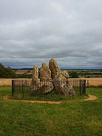
Apparently the earliest of the Rollright Stones, the Whispering Knights are the remains of the burial chamber of an Early or Middle Neolithic portal dolmen lying 450 yards east of the King's Men.[11] Four standing stones survive, forming a chamber about two square metres in area around a fifth recumbent stone, probably the collapsed roof capstone.[7][12] Although archaeologists and antiquarians had been speculating and debating the nature of the Whispering Knights for centuries, more about the monument was only revealed following the excavations carried out around the stones by George Lambrick and his team during the 1980s.[13] They revealed that the portal dolmen had never been a part of a longer cairn, as had been suggested by some earlier investigators, and uncovered a few pieces of Neolithic pottery around the monument.[14]
Writing in 1743, the antiquarian William Stukeley described the Whispering Knights as sitting upon a round barrow, something that Lambrick accepted as being "reasonable in the context of a portal dolmen", however he cautioned against accepting such an explanation too readily. He went on to argue that a "mound-like effect" could have been created at the base of the monument if ploughing in later centuries had led to the accumulation of soil around the dolmen's uphill side and the removal of it on the downhill side.[7] Excavation failed to provide evidence to prove either suggestion, leaving the issue "ambiguous"; Lambrick noted however that there was a possibility that some of the stratigraphic layers "may represent the base of some sort of cairn" around the Whispering Knights.[14]
Lambrick believed that raising the capstone on the Whispering Knights would have been the hardest task in the entirety of the Rollrights' construction, remarking that it was "analogous" to the raising of the lintels on Stonehenge. He suggested the possibility that the builders had constructed a ramp out of "collected stones", which was then "placed against the back of the chamber", with the capstone then being "hauled up on rollers, probably running on logs embedded longitudinally in the ramp" in order to get it into position.[9]
The King's Men
The King's Men is a stone circle 108 feet in diameter, currently composed of seventy-seven closely spaced stones.[15] Being a stone circle, it was constructed at some point during the Late Neolithic or Early Bronze Age in British prehistory.[11]
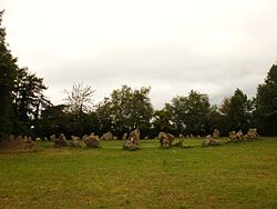
After undertaking limited excavation at the circle in the 1980s, archaeologist George Lambrick concluded that when it had been originally erected, it would have been a "more perfect circle" than it is today, with each of the stones touching one another, creating a continuous barrier all the way around. He also speculated that the monument's builders intentionally chose the smoother sides of the boulders that they were using to face inwards, something evidenced by the fact that the outer facing sides are predominantly rougher in texture.[15][16]
Resistivity and magnetometry surveys undertaken during the 1980s revealed four magnetic anomalies within the centre of the circle, possibly representing "pits related in some way to local ground surface undulations and the presence of localised burning."[17] Lambrick noted that similar features could be found within the stone circles of Mayburgh, Stenness and Balbirnie, suggesting that it was a possible original prehistoric feature, although accepted that it could equally be the result of refuse deposited in the Romano-British period or tree-planting holes.[18] Meanwhile, archaeological excavation also revealed that there was "no indication" of there being "a substantial ditch" either inside or outside the bank on which the stones were positioned.[19]
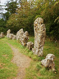
Making an estimate of the time and manpower that it would have taken to transport the boulders to the site and then erect them, Lambrick concluded that each of the King's Men could have been constructed by a team of ten or twenty (depending on the size of the stone) in about two-and-a-half hours. He noted however that this would have been speeded up if the workers had divided into two groups for some of the smaller stones. Concluding his examination of this issue, he argued that "83 journeys by the whole team would have been required, giving an actual construction time of c 137 hours, or 3735 manhours." Adding to this "210 manhours" for digging the post holes for the boulders, as well as "40 manhours for cutting timber and making the shear-legs and sledges" and also "another 40 for fetching and trimming the timbers", Lambrick came to the conclusion that a total of around "4035 manhours" would have gone into the construction of the stone circle, taking up about three weeks' work for around twenty workers.[20]
As it stands today, the monument is in part a reconstruction, because in 1882, the owner of the site re-erected around a third of the stones that had previously fallen, and in doing so some were moved out of their original positions.[21] Using documentary evidence and lichen growth analysis, archaeologists have also established that around that time, several new stones were added to the circle in order to fill in gaps where the original stone had been lost or destroyed, although Lambrick doubted that any more than two of those currently standing were modern additions, with four of the other, smaller additions having been stolen by vandals in the 20th century.[22]
The King Stone
The King Stone is a single, weathered monolith, 7.9 feet high by 4.9 feet wide, standing 83 yards north of the King's Men. Unlike the other two of the Rollright monuments, it is of uncertain date.[11] Many different interpretations have been made of the King Stone, with various arguments being presented as to what it had originally been designed to be. Lambrick catalogued six distinct hypotheses that had been presented by antiquarians and archaeologists over the preceding centuries and evaluated their likelihood. Some of these argued that it had been positioned in relation to the King's Men stone circle, with others instead suggesting that it was a component of a long barrow or other burial site.[18]
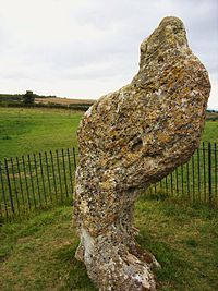
The purpose of the King Stone has not been satisfactorily explained. Lockyer (1909) and Thom (1967) made their accustomed suggestion of its being an astronomical marker, although it appears not to align with any star or event of importance with King's Men. Aubrey Burl (1976) suggested that the King Stone as a landmark or guidepost designed to mark out the position of the King's Men, but singularly fails to do so. John Aubrey and Arthur Evans suggested that the monolith was a surviving remnant of a stone avenue that had once led to the King's Men, but Lambrick disagreed, noting that there was no other archaeological evidence for such an avenue, and that it would have been poorly aligned with the circle.[18]
Other suggestions have been put forward arguing that the stone was once a part of a long barrow, but this has been dismissed since archaeological investigation in the 1980s failed to reveal any other evidence for such a monument.[18] Another hypothesis arguing that it was associated with burial had been put forward by Bloxham in 1874, when he suggested that it marked the position of a burial or wider cemetery.[18] It was this view that was adopted by Lambrick, who subsequently "tentatively" interpreted the monolith as a cemetery marker, primarily because of the "unsatisfactory nature of other explanations and the existence nearby of Bronze Age barrows and cremations, one of which had been marked by a broad wooden post."[11]
Lambrick estimated that when it was originally erected, the King Stone would have weighed somewhere in the region of 4.7 tons, but that since then much of it has been chipped away.[9] Using his own estimates, Lambrick suggested that with a team of 58 workers, the King Stone could have been set up in about two hours. [20]
Folklore
Early Modern period
Numerous folktales are associated with the stones,[23] including the tale reported in a rhyming version by William Camden in 1610,[24] that a king was riding across the county with his army when he was accosted by a local witch called Mother Shipton,[25] who said to him:
Seven long strides thou shalt take, says she
And if Long Compton thou canst see,
King of England thou shalt be!
His troops gathered in a circle to discuss the challenge and his knights muttered amongst themselves– but the king boldly took seven steps forward. Rising ground blocked his view of Long Compton in the valley and the witch cackled:
As Long Compton thou canst not see, King of England thou shalt not be! Rise up stick and stand still stone, For King of England thou shalt be none; Thou and thy men hoar stones shall be, And I myself an elder tree!
The king became the solitary King Stone, while nearby his soldiers formed a cromlech, or circle, called the King's Men. As the witch prepared to turn herself into an elder tree, she backtracked into four of the king's knights, who had lagged behind and were whispering plots against the king. She turned them to stone as well, and today they are called the Whispering Knights.
18th and 19th centuries
Legend holds that as the church clock strikes midnight, the King Stone comes alive[26] and the king and his men come to life on certain saints' days.[27]
According to 18th-century lore, village maids would sneak out to the Whispering Knights on Midsummer's Eve and listen carefully, hoping to be whispered their future and fate. It is said that one cannot accurately count the stones and that a different tally will result each time an attempt is made.
The King Stone was fenced off between the two World Wars to prevent conscripted troops chipping off a piece of stone to carry with them, since legend suggested that this would give protection in battle. But it is considered unlucky to touch the King's Men.
Antiquarian and archaeological investigation and preservation
Mediæval accounts
The earliest known written account describing the Rollrights comes from the 14th century, during the Late Mediæval period in Britain. It was at this time that an unknown author wrote a tract entitled De Mirabilibus Britanniae (The Wonders of Britain) in which the prehistoric monuments at Stonehenge and the White Horse of Uffington were mentioned alongside the Rollrights.[28] As the author related:
In the neighbourhood of Oxford there are great stones, arranged as it were in some connection by the hand of man. But at what time; or by what people; or for what memorial or significance, is unknown. Though the place is called by the inhabitants Rollendrith.[28]
The nearby village, Great Rollright, is spelt as "Magna Rollandryght" in 1430.[29]
Early Modern antiquarianism
"[A] little river... speedeth him into Isis: which riveret on the very border of the shire passeth by an ancient Monument standing not farre from his bank, to wit, certaine large stones placed in a round circle (the common people usually call them Rolle-rich stones, and dreameth that they were sometimes men by a wonderfull Metamorphosis turned into hard stones)."
It was in the 16th century, during the Early Modern period of British history, that further written accounts of the Rollrights were made; one of the earliest of these was provided by the pioneering antiquarian John Leland (c.1503–1552) in his unpublished account of his travels across England, Itinerary. Nonetheless, despite the fact that he referred to it, he failed to go into any detail.[28]
A more detailed account was made by his fellow antiquarian, William Camden (1551–1623), who wrote about it in his 1586 work Britannia, a topographical and historical survey of all of Great Britain and Ireland. Describing the stones and some of the folklore that the locals attributed to them, Camden went on to hypothesise that they were constructed as a "memorial of some victory, perhaps by Rollo the Dane, who later possessed property in Normandy."[28]
Sheldon Tapestry Map
An Elizabethan tapestry map of Warwickshire (the Sheldon Tapestry Map), created during the late 1580s for hanging in the home of Ralph Sheldon of Long Compton, is believed to be the earliest known depiction of the Rollright Stones on a map. After conservation and cleaning of the tapestry in 2012 it was noted for the first time that a number of monoliths, perhaps forming a stone circle, appear to be shown in the vicinity of Long Compton.[30]
Inspectorate of Ancient Monuments investigation: 1981–86
At the start of the 1980s, the state-appointed Inspectorate of Ancient Monuments commissioned an investigation into the Rollright Stones and their immediate surroundings "in order that a fully integrated policy for the future preservation and management of the complex might be formulated."[2] This investigation took place between 1981 and 1982, and involved both archaeologists and historical researchers. As a part of the initial survey, historians undertook documentary research, examining the reports and accounts of the site that had been produced since the 17th century, with particular emphasis on antiquarian and early archaeological drawings. Aerial photographs of the area were looked at for signs of prehistoric crop marks, whilst both a geophysical survey and a fieldwalk of the area were undertaken.[2]
With the surveying over, the investigators moved on to excavation, opening up several limited trial trenches, as well as excavating in its entirety one small round barrow, which had been heavily ploughed out.[2] Excavator George Lambrick noted that, although the excavations had "limited scope", "a substantial new body of data" was uncovered, revealing a number of lithics, pieces of pottery, soil profile changes, molluscan assemblages, carbonised plant remains and both animal and human bones, allowing archaeologists to build up a much wider image of the site and its surroundings.[2]
An interim report on the project's findings was published in a booklet written by Lambrick in 1983.[31] He followed this up with an outline of the management history of the Stones, published in 1986.[32] Lambrick's third book on the monument appeared in 1988, published by English Heritage as The Rollright Stones: Megaliths, monuments, and settlement in the prehistoric landscape. Containing the full site report, it was "the first full record and analysis of the King's Men, the Whispering Knights, the King Stone, and their archaeological setting" and, in the book's preface, the then Inspector of Ancient Monuments A.J. Fleming commented that the "survey provides a firm basis for the improved management of the monument."[33]
Popular culture
- Author Penelope Lively uses the Rollright Stones as a central motif in her 1971 children's novel The Whispering Knights.
- The British rock band Traffic recorded a song named Roll Right Stones for their 1973 album Shoot Out at the Fantasy Factory.
- Indie band Half Man Half Biscuit mention the stones in their song Twenty Four Hour Garage People on their 2000 album Trouble Over Bridgwater.
I fancy I'll open a stationer's,
Stock quaint notepads for weekend pagans
While you were out at the Rollright Stones
I came and set fire to your shed.
- On 13 June 1978 scenes for the Doctor Who story The Stones of Blood were filmed here. The Rollright Stones represented a fictional group of standing stones called The Nine Travellers.
- In The Long Earth by Terry Pratchett and Stephen Baxter, the stones appear briefly as a place where trolls step into Datum Earth, and beating the stones makes a harmonic to drive them off again.
Outside links
| ("Wikimedia Commons" has material about Rollright Stones) |
- Rollright Stones
- Rollright Stones at Megalithia.com
- Pictures of The Rollright Stones and the area on Geograph.co.uk
- BBC 360 degree photograph
- Megalithic
References
- ↑ Brian M. Fagan, From Stonehenge to Samarkand: an anthology of archaeological travel writing 2006:6
- ↑ 2.0 2.1 2.2 2.3 2.4 2.5 2.6 Lambrick 1988. p. 1.
- ↑ Burl 2005. p. 72.
- ↑ Pearson 2005. p. 34.
- ↑ Parker Pearson 2005. pp. 58–59.
- ↑ 6.0 6.1 6.2 Lambrick 1988. p. 27.
- ↑ 7.0 7.1 7.2 Lambrick 1988. p. 28.
- ↑ See Atkinson 1960.
- ↑ 9.0 9.1 9.2 Lambrick 1988. p. 49.
- ↑ Lambrick 1988. p. 51.
- ↑ 11.0 11.1 11.2 11.3 Lambrick 1988. p. 136.
- ↑ Lambrick 1988. p. 34.
- ↑ Lambrick 1988. pp. 28–32.
- ↑ 14.0 14.1 Lambrick 1988. p. 32.
- ↑ 15.0 15.1 Lambrick 1988. pp. 41–42.
- ↑ Lambrick 1988. p. 46.
- ↑ Lambrick 1988. pp. 38–41.
- ↑ 18.0 18.1 18.2 18.3 18.4 Lambrick 1988. p. 48.
- ↑ Lambrick 1988. pp. 42.
- ↑ 20.0 20.1 Lambrick 1988. p. 50.
- ↑ Lambrick 1988. pp. 35, 41.
- ↑ Lambrick 1988. pp. 38, 41.
- ↑ Some folklore is assembled by Arthur J. Evans, "The Rollright Stones and their folk-lore", Folk-Lore 6 (1895:18f.
- ↑ Camden, Britannia.
- ↑ Anon. "Rollright Stones". BBC: Where I live:Oxford. BBC. http://www.bbc.co.uk/oxford/features/360/rollright_stones.shtml. Retrieved 19 June 2009.
- ↑ Katharine Mary Briggs, Folklore of the Cotswolds (1974:14).
- ↑ Evans 1895:24.
- ↑ 28.0 28.1 28.2 28.3 Lambrick 1988. p. 5.
- ↑ Plea Rolls of the Court of Common Pleas; National Archives; CP 40 / 677; http://aalt.law.uh.edu/AALT1/H6/CP40no677/bCP40no677dorses/IMG_0989.htm; 5th entry; where Thomas Mageton, husbandman lives, as seen on the second line
- ↑ Sharpe, Emily (30 August 2012). "Ancient stones revealed on tapestry". The Art Newspaper. http://www.theartnewspaper.com/articles/Ancient+stones+revealed+on+tapestry/27052. Retrieved 2 September 2012.
- ↑ Lambrick 1983.
- ↑ Lambrick 1986.
- ↑ Lambrick 1988. p. vi.
Books
Academic books
- Adkins Roy; Adkins, Lesley and Leitch, Victoria (2008). The Handbook of British Archaeology (Revised Edition). London: Constable. ISBN 978-1-84529-606-3.
- Atkinson, R.J.C. (1960). Stonehenge. London: Hamish Hamilton. ISBN 0-14-020450-4.
- Barrett, John C. (1994). Fragments from Antiquity: An Archaeology of Social Life in Britain, 2900–1200 BC. Oxford, UK and Cambridge, USA: Blackwell. ISBN 978-0-631-18954-1.
- Blain, Jenny and Wallis, Robert (2007). Sacred Sites Contested Rites/Rights: Pagan Engagements with Archaeological Monuments. Brighton and Portland: Sussex Academic Press. ISBN 978-1-84519-130-6.
- Bradley, Richard (2007). The Prehistory of Britain and Ireland. New York: Cambridge University Press. ISBN 978-0-521-61270-8.
- Burl, Aubrey (2005). A Guide to the Stone Circles of Britain, Ireland and Brittany (Revised Edition). New Haven and London: Yale University Press. ISBN 978-0-300-11406-5.
- Doyle White, Ethan (2014). "Devil's Stones and Midnight Rites: Folklore, Megaliths, and Contemporary Pagan Witchcraft". Folklore 125 (1): 60–79. doi:10.1080/0015587x.2013.860766.
- Gillings, Mark and Pollard, Joshua (2004). Avebury. London: Gerald Duckworth & Co. ISBN 0-7156-3240-X.
- Hutton, Ronald (1991). The Pagan Religions of the Ancient British Isles: Their Nature and Legacy. Oxford and Cambridge, Massachusetts: Blackwell. ISBN 978-0-631-17288-8.
- Lambrick, George (1983). The Rollright Stones. Oxford: Oxford Archaeological Unit. ISBN 0-904220-04-4.
- Lambrick, George (1988). The Rollright Stones: Megaliths, monuments, and settlement in the prehistoric landscape. London: English Heritage. ISBN 1-85074-192-1.
- Malone, Caroline (2001). Neolithic Britain and Ireland. Stroud, Gloucestershire: Tempus. ISBN 0-7524-1442-9.
- Parker Pearson, Michael (2005). Bronze Age Britain (Revised Edition). London: B.T. Batsford and English Heritage. ISBN 978-0-7134-8849-4.
- Williams, Mike (2010). Prehistoric Belief: Shamans, Trance and the Afterlife. Stroud, Gloucestershire: The History Press. ISBN 978-0-7524-4921-0.
Academic papers
- Arthur Evans (1895). "The Rollright Stones and Their Folk-Lore". Folklore 6 (1): 6–53.
- Lambrick, George (1986). M. Hughes and L. Rowley. ed. "The Rollright Stones, a case study in monument management". The Management and Presentation of Field Monuments (Oxford: Oxford University Department for External Studies): 109–22. ISBN 0-903736-21-7.
- Richards, Colin (1996). "Monuments as Landscape: creating the centre of the world in late Neolithic Orkney". World Archaeology 28: 190–208. doi:10.1080/00438243.1996.9980340.
- Wright, Thomas (1879). "Legend of the Rollright Stones". The Folk-Lore Record 2: 177–179.
