Wigston: Difference between revisions
Created page with "{{Infobox town |county=Leicestershire |name=Wigston Magna |picture=WigstonMagnaTown-4.jpg |picture caption=Council offices in Wigston |os grid ref=SP608992 |latitude=52.5812 |..." |
mNo edit summary |
||
| Line 14: | Line 14: | ||
|constituency=Harborough | |constituency=Harborough | ||
}} | }} | ||
'''Wigston''' is a town in [[Leicestershire]], immediately to the south of [[Leicester]], on the A5199 road which leads to [[Northampton]]. The town of today is a conglomeration of villages, of which the heart | '''Wigston''' is a town in [[Leicestershire]], immediately to the south of [[Leicester]], on the A5199 road which leads to [[Northampton]]. The town of today is a conglomeration of villages, of which the heart is '''Wigston Magna''' or 'Great Wigston'', also historically referred to as 'Wigston Two Steeples'. | ||
To the west along the B582, or Blaby Road is [[South Wigston]], also now within the conglomerated town. | To the west along the B582, or Blaby Road is [[South Wigston]], also now within the conglomerated town. | ||
Latest revision as of 22:43, 19 April 2015
| Wigston Magna | |
| Leicestershire | |
|---|---|
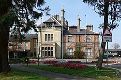
 Council offices in Wigston | |
| Location | |
| Grid reference: | SP608992 |
| Location: | 52°34’52"N, 1°5’35"W |
| Data | |
| Population: | 25,645 |
| Post town: | Wigston |
| Postcode: | LE18 |
| Dialling code: | 0116 |
| Local Government | |
| Council: | Oadby and Wigston |
| Parliamentary constituency: |
Harborough |
Wigston is a town in Leicestershire, immediately to the south of Leicester, on the A5199 road which leads to Northampton. The town of today is a conglomeration of villages, of which the heart is Wigston Magna or 'Great Wigston, also historically referred to as 'Wigston Two Steeples'.
To the west along the B582, or Blaby Road is South Wigston, also now within the conglomerated town.
The Grand Union Canal runs from Wistow, south of Wigston, to nearby Kilby Bridge, and for several miles through South Wigston, Glen Parva, Blaby and on towards Leicester itself.
Wigston's population of approximately 30,000 live in both the post-war private suburban housing estates surrounding the old town centre, and the 19th century buildings now sandwiched between modern housing developments. The oldest of the post-war developments is Wigston Fields located to the north of Wigston towards Knighton and Leicester; the Meadows and Little Hill estates were later developed during the 1970s and 1980s to the east and south of Wigston's old centre. Wigston Harcourt is an area of housing developed up until the early 1990s between the Little Hill and Meadows estates. These three estates mark the boundary of the greater Leicester urban area, beyond which lies agricultural land.
History
One of the earliest records of Wigston is in the Domesday Book where it is listed amongst the lands held by Hugh de Grandmesnil[1] for the King.
In the Middle Ages it was known as Wigston Two Spires as, unusually, there were two mediæval churches there, All Saints' and St Wistan's.
St Wistan's is so called because it was one of the places where the body of St Wistan or Wigstan rested before burial. He was initially buried at Repton, but his body was then moved to Evesham. Wigstan was a Mercian prince who was assassinated, but was regarded as a Martyr.
About the town
Bushloe House, now the Council Offices of the Oadby and Wigston Borough Council, was originally a c1850 house which was extended in c1880. The interior decoration of the house and the design of most of the furniture (and possibly the design of the extension) was carried out by Christopher Dresser for the owner, his solicitor, Hiram Abiff Owston (1830–1905).
There is a Framework Knitting Museum here, as it was an important occupation in this area from the 17th to 19th centuries. Hosiery manufacture continued to be an important industry in the town after the decline of hand process of framework knitting with manufacturing firms such as Two Steeples, Wigston Co-Operative Hosiers, A H Broughton and William Holmes. In neighbouring South Wigston Henry Bates was the leading hosiery manufacturer.
Wigston was the subject of W G Hoskins's pioneering historical study, The Midland Peasant (London: Macmillan, 1965), which traced the social history of this village from earliest recorded history into the 19th century.
Local economy
Since the 1980s Wigston's retail economy has become increasingly dependent on national retailers. Up to 50% of retail in the town belongs to supermarkets and chain stores. The share of local business has caused local and independent businesses to close. This followed the trend of the 1990s homogenisation of British high streets.
A number of independent stores survive and thrive though, including two car dealerships, hair and beauty salons, opticians, florists, fish and chip shop, fish sellers, newsagents, and public houses. It has several charity shops though.
There is a concentration of companies on the industrial estate located on Chartwell Drive including the Cromwell Tools World Distribution Centre and Delifrance.
Outside links
- WebWigston
- Wigston Band
- Leicestershire Villages - Wigston
- All Saints and St Wistan churches
- All Saints CE Primary School
- Framework Knitting Museum
- Abington Academy
- [1]
References
- ↑ Domesday Book: A Complete Transliteration. London: Penguin, 2003. p. 652 ISBN 0-14-143994-7