River Wampool: Difference between revisions
Jump to navigation
Jump to search
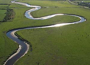
Created page with "right|thumb|300px|River Wampool near Angerton {{county|Cumberland}} The '''River Wampool''' is a river flowing through north-w..." |
No edit summary |
||
| Line 13: | Line 13: | ||
== == | == == | ||
*Map: {{wmap| | *Map: {{wmap|54.90|-3.317|zoom=12}} | ||
[[Category:Rivers of Cumberland|Wampool River]] | [[Category:Rivers of Cumberland|Wampool River]] | ||
Latest revision as of 22:11, 14 April 2015

The River Wampool is a river flowing through north-western Cumberland to the Solway Firth.
The river is formed at Chalkfoot near East Curthwaite, above which it is known as Chalk Beck.
Course
Chalk Beck rises close to Wavergillhead and runs north, meeting Iron Gill and proceeding through a wooded clough to Chalkfoot.
Later, the infant River Wampool is joined by Gill Beck at West Curthwaite and Whinnow Beck at Micklethwaite.
The river continues northwards through Biglands, where it is joined by Bampton Beck, and Wampool, towards Angerton, where it bends westwards, meeting Solway Firth at Anthorn.
- Map: 54°54’-0"N, 3°19’1"W