Westruther: Difference between revisions
Jump to navigation
Jump to search
Created page with "{{Infobox town |name= Westruther |county=Berwickshire |picture=Westruther.jpg |picture caption=Westruther |os grid ref= NT63374903 |latitude=55.733333 |longitude=-2.583333 |po..." |
No edit summary |
||
| Line 12: | Line 12: | ||
|postcode= | |postcode= | ||
|dialling code= | |dialling code= | ||
|LG district= | |LG district=Scottish Borders | ||
|constituency= | |constituency=Berwickshire, Roxburgh & Selkirk | ||
}} | }} | ||
'''Westruther''' is a village on the B6468, in [[Berwickshire]], on the lower slopes of the [[Lammermuir|Lammermuir Hills]]. The largest town nearby is wee [[Gordon]]. | '''Westruther''' is a village on the B6468, in [[Berwickshire]], on the lower slopes of the [[Lammermuir|Lammermuir Hills]]. The largest town nearby is wee [[Gordon]]. | ||
Latest revision as of 23:19, 30 January 2015
| Westruther | |
| Berwickshire | |
|---|---|
 Westruther | |
| Location | |
| Grid reference: | NT63374903 |
| Location: | 55°43’60"N, 2°34’60"W |
| Data | |
| Local Government | |
| Council: | Scottish Borders |
| Parliamentary constituency: |
Berwickshire, Roxburgh and Selkirk |
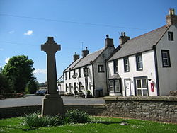
Westruther is a village on the B6468, in Berwickshire, on the lower slopes of the Lammermuir Hills. The largest town nearby is wee Gordon.
Places nearby include Duns, Greenlaw, the Lammermuir Hills, Longformacus and the Watch Water Reservoir.

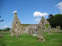
The ruined kirk dates from 1649 and contains the tombs of the Spottiswoode family. A prominent member of the family was Alicia Ann Spottiswoode, known also as Lady John Scott of "Annie Laurie" fame. There is a stained glass window in her honour in the "new" kirk dating from 1834.