Weston Colville: Difference between revisions
Created page with '{{Infobox town |name=Weston Colville |county=Cambridgeshire |picture=Weston Colville, St Mary - geograph.org.uk - 2974.jpg |picture caption=Church of St Mary at Weston Colville |…' |
mNo edit summary |
||
| Line 4: | Line 4: | ||
|picture=Weston Colville, St Mary - geograph.org.uk - 2974.jpg | |picture=Weston Colville, St Mary - geograph.org.uk - 2974.jpg | ||
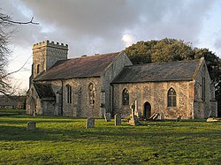
|picture caption=Church of St Mary at Weston Colville | |picture caption=Church of St Mary at Weston Colville | ||
|os grid ref= | |os grid ref=TL616531 | ||
|latitude=52.153 | |latitude=52.153 | ||
|longitude=0.362 | |longitude=0.362 | ||
Latest revision as of 21:15, 8 June 2014
| Weston Colville | |
| Cambridgeshire | |
|---|---|
 Church of St Mary at Weston Colville | |
| Location | |
| Grid reference: | TL616531 |
| Location: | 52°9’11"N, -0°21’43"E |
| Data | |
| Population: | 424 (2001) |
| Post town: | Cambridge |
| Postcode: | CB21 |
| Dialling code: | 01223 |
| Local Government | |
| Council: | South Cambridgeshire |
Weston Colville is a village in the hills that extend into south-eastern Cambridgeshire, 10 miles southeast of Cambridge and 6 miles south of Newmarket, close to the border with Suffolk.
Church
The parish church of St Mary consists of a chancel with north vestry, nave with south porch, and west tower. The nave dates from the 14th century, with the tower added in the 15th century. The external stone dressings were mainly replaced by grey brick in the 1820s.[1]
Big Society
The village retains a post office and has its own cricket club. The Reading Room hosts local events, family gatherings and is the regular venue for The Bumblebees, an Art class and a Pilates class.
There are no pubs remaining in the village. Former pubs include The Coopers Arms which opened in the late 18th century, The Three Horseshoes, north of Weston Green, which ran from 1800 until closing in 1957, and The Fox and Hounds south of the green, open in the mid-19th century, rebuilt in around 1940, but closed in the late 20th century.[1]
History
The parish of Weston Colville forms a long thin area of 3235 acres stretching from just south of the A11 to the Suffolk border. It is wedged between the parishes of Carlton-cum-Willingham to the north and West Wratting to the south, and at the foot of the hills it has a short border with the two parishes of Great Wilbraham and Little Wilbraham to the northwest.[1]
The site has been occupied since at least the 10th century, and there were 40 residents registered at the time of the Domesday Book. By 1150 the manor was owned by the Stutville family. After the death of Anselm de Stutville in around 1198, the land passed to his sister Beatrice, who married William de Colville, lord of Castle Bytham in around 1200. From then until 1708 the manor remained in the hands of the Colville family, who added their name to the village which was hitherto known only as Weston (meaning "west village").[1]
Between 1943 and 1947 the flat area southeast of the village was used as a bomber airfield during the Second World War known as Wratting Common. The buildings there also housed 2000 foreign refugees at one time. The area returned to agricultural use after 1952.[1]
J R Withers (1812–92), "the Cambridgeshire poet", was born at Weston Colville, son of the village shoemaker, though he lived at Fordham as an adult.[1]
Outside links
| ("Wikimedia Commons" has material about Weston Colville) |
