Ockley: Difference between revisions
Created page with '{{Infobox town | county = Surrey | name= Ockley | picture=The Well at Ockley. - geograph.org.uk - 111892.jpg | picture caption=The well on Ockley Green | latitude= 51.1477 | long…' |
No edit summary |
||
| Line 15: | Line 15: | ||
| dialling code= 01306 | | dialling code= 01306 | ||
}} | }} | ||
'''Ockley''' is a pretty little village in [[Surrey]], built on [[Stane Street (Chichester)|Stane Street]], the route of a Roman Road stretching from [[Chichester]] to [[London]] and now covered by the A29. Ockley is a long, thin village running along the A29 and lying about 2 miles east of the A24. | |||
'''Ockley''' is a pretty little village in [[Surrey]], built on [[Stane Street (Chichester)|Stane Street]], the route of a Roman Road stretching from [[Chichester]] to [[London]] and now covered by the A29. Ockley is a long, thin village running along the A29 and lying about | |||
Situated between [[Dorking]] and [[Horsham]], close to the Sussex/Surrey border, Ockley nestles in the shadows of [[Leith Hill]], the highest point in south-eastern England. Neighbouring villages include [[Capel, Surrey|Capel]], [[Ewhurst Green]] and [[Rusper]]. | Situated between [[Dorking]] and [[Horsham]], close to the Sussex/Surrey border, Ockley nestles in the shadows of [[Leith Hill]], the highest point in south-eastern England. Neighbouring villages include [[Capel, Surrey|Capel]], [[Ewhurst Green]] and [[Rusper]]. | ||
Latest revision as of 21:51, 13 September 2010
| Ockley | |
| Surrey | |
|---|---|
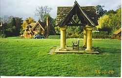
 The well on Ockley Green | |
| Location | |
| Grid reference: | TQ146399 |
| Location: | 51°8’52"N, 0°21’46"W |
| Data | |
| Population: | 852 (2001) |
| Post town: | Dorking |
| Postcode: | RH5 |
| Dialling code: | 01306 |
| Local Government | |
| Council: | Mole Valley |
| Parliamentary constituency: |
Mole Valley |
Ockley is a pretty little village in Surrey, built on Stane Street, the route of a Roman Road stretching from Chichester to London and now covered by the A29. Ockley is a long, thin village running along the A29 and lying about 2 miles east of the A24.
Situated between Dorking and Horsham, close to the Sussex/Surrey border, Ockley nestles in the shadows of Leith Hill, the highest point in south-eastern England. Neighbouring villages include Capel, Ewhurst Green and Rusper.
There are four pubs in Ockley: Cricketer's Arms, Inn on the Green, King's Arms and Bryce's Restaurant (also known as the Old School House). In addition to the pubs, Ockley has a Post Office & village shop and garage, and a local veg shop out towards the station. There is also a golf course called 'Gatton Manor' on the outskirts of the village.
Ockley railway station lies over two miles to the east of the village, with few trains stopping and no Sunday service.
Nicholas Culpeper, the famous Herbalist, was born here on 18th October 1616.
Above the village is the hamlet of Coldharbour, the site of a triple-vallate iron-age hill fort known as Anstiebury Camp.[1]
Ockley appears to be the Aclea at which in 851 King Aethelwulf of Wessex defeated a Danish invasion. According to the Anglo-Saxon Chronicle, 350 heathen ships sailed up the Thames and sac ked London. The main Viking force then advanced to Aclea where the King and Price Alfred defeated them with much slaughter.
Domesday Book entry
Ockley appears in Domesday Book of 1086 as Hoclei. It was held by Radulf from Richard Fitz Gilbert. Its assets were: 1 hide. It had 5 ploughs, woodland worth 20 hogs. It rendered £3 10s 0d.[2]