Carlton Husthwaite: Difference between revisions
Created page with "{{Infobox town |county=Yorkshire |riding=North |picture=Village Street, Carlton Husthwaite.jpg |picture caption=Village Street, Carlton Husthwaite |os grid ref=SE490765 |latit..." |
|||
| Line 21: | Line 21: | ||
[[File:Carlton Husthwaite Church - geograph.org.uk - 1072150.jpg|left|thumb|200px|St Mary's Church]] | [[File:Carlton Husthwaite Church - geograph.org.uk - 1072150.jpg|left|thumb|200px|St Mary's Church]] | ||
==Parish church== | ==Parish church== | ||
There is a church in the village, St Mary's. It is a Grade II* listed building.<ref>{{ | There is a church in the village, St Mary's. It is a Grade II* listed building.<ref>{{NHLE|1190878|Church of St Mary|grade=II*}}</ref> | ||
The church was built in 1685 as a ''chapel of ease'', though there may have been an earlier building on the same site.<ref>{{cite web|url=http://www.husthwaitehistory.co.uk/assets/Carlton_Domesday.pdf|title=History|accessdate=29 December 2012}}</ref> It underwent a renovation in 1885. | The church was built in 1685 as a ''chapel of ease'', though there may have been an earlier building on the same site.<ref>{{cite web|url=http://www.husthwaitehistory.co.uk/assets/Carlton_Domesday.pdf|title=History|accessdate=29 December 2012}}</ref> It underwent a renovation in 1885. | ||
Latest revision as of 23:37, 24 May 2023
| Carlton Husthwaite | |
| Yorkshire North Riding | |
|---|---|
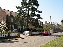
 Village Street, Carlton Husthwaite | |
| Location | |
| Grid reference: | SE490765 |
| Location: | 54°11’1"N, 1°14’16"W |
| Data | |
| Population: | 180 (2011) |
| Post town: | Thirsk |
| Postcode: | YO7 |
| Local Government | |
| Council: | North Yorkshire |
| Parliamentary constituency: |
Thirsk and Malton |
Carlton Husthwaite is a village in the North Riding of Yorkshire, about seven miles south-east of Thirsk. The 2011 Census recorded a population of 180.
The nearest settlements to the village are Birdforth a mile to the south-west; Thormanby a mle to the south; Husthwaite a mile and a half to the south-east; Coxwold two and a half miles to the east and Thirkleby two miles to the north-east.

Parish church
There is a church in the village, St Mary's. It is a Grade II* listed building.[1]
The church was built in 1685 as a chapel of ease, though there may have been an earlier building on the same site.[2] It underwent a renovation in 1885.
A Wesleyan Chapel was also built in the village in 1869, but is now a private residence.[3]
History
The village is mentioned in the Domesday Book as Carleton in the Yarlestre hundred. At the time of the Norman invasion, the lord of the manor was Ulf of Carleton, subsequently the lands were granted to the Archbishop of York.[4][3]
The name 'Carlton' is commonplace in Yorkshire. It is derived from a combination the Old Norse word Carl, meaning free peasants, and the Old English word -tun, meaning farm or settlement. The second part of the name is derived from the Old Norse words of Hus and thwaite, for houses and meadow respectively.[5]
Outside links
| ("Wikimedia Commons" has material about Carlton Husthwaite) |
References
- ↑ National Heritage List 1190878: Church of St Mary (Grade II* listing)
- ↑ "History". http://www.husthwaitehistory.co.uk/assets/Carlton_Domesday.pdf. Retrieved 29 December 2012.
- ↑ 3.0 3.1 Bulmer's Topography, History and Directory (Private and Commercial) of North Yorkshire 1890. S&N Publishing. 1890. p. 722. ISBN 1-86150-299-0.
- ↑ Husthwaite Carlton Husthwaite in the Domesday Book
- ↑ "Etymology". http://www.yorkshire-england.co.uk/PlaceNameMeaningsAtoD.html. Retrieved 29 December 2012.
