Millennium Footbridge, Stretford: Difference between revisions
Created page with "{{Infobox bridge |name=Millennium Footbridge |county 1=Cheshire |county 2=Lancashire |picture=River Mersey, Urmston - geograph.org.uk - 50016.jpg |picture caption=The Ashton B..." |
No edit summary |
||
| Line 3: | Line 3: | ||
|county 1=Cheshire | |county 1=Cheshire | ||
|county 2=Lancashire | |county 2=Lancashire | ||
|picture= | |picture=The Millennium Footbridge, Stretford - geograph-4073708.jpg | ||
|picture caption=The | |picture caption=The Millennium Footbridge | ||
|os grid ref=SJ77269358 | |os grid ref=SJ77269358 | ||
|latitude= 53.438489 | |latitude= 53.438489 | ||
Latest revision as of 23:49, 9 January 2021
| Millennium Footbridge | |
| Cheshire, Lancashire | |
|---|---|
 The Millennium Footbridge | |
| Location | |
| Carrying: | Footpath |
| Crossing: | River Mersey |
| Location | |
| Grid reference: | SJ77269358 |
| Location: | 53°26’19"N, 2°20’38"W |
| Structure | |
| History | |
| Information | |
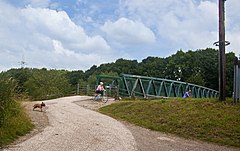
The Millennium Footbridge is a footbridge across the River Mersey built to mark the beginning of the Third Millennium. It is at the edge of Stretford in Lancashire, immediately beside the Ashton Bridge carrying the A6144, a motorway spur road rather unwelcoming of pedestrians. The bridge runs above a weir.
Here the Mersey is allowed to follow its natural course: a short distance below, it runs into the area of industrial development which have in places perverted its course, and before too long it is wholly diverted to serve the Manchester Ship Canal. Here by Stretford though the Mersey is free, and marks the border between Lancashire on the north bank and Cheshire on the south.
The footbridge is used by the route of the Trans Pennine Trail.
| Bridges and crossings on the River Mersey | ||||||
|---|---|---|---|---|---|---|
| Pipe bridge | Aqueduct | Flixton Bridge | Millennium Footbridge | Ashton Bridge | Crossford Bridges | M60 |