Gedney Marsh: Difference between revisions
Jump to navigation
Jump to search
Created page with "right|thumb|300px|A drain on Gedney Marsh {{county|Lincolnshire}} '''Gedney Marsh''' is an areas of the Great..." |
No edit summary |
||
| Line 10: | Line 10: | ||
{{Gedney}} | {{Gedney}} | ||
[[ | [[Category:Lincolnshire fens]] | ||
Revision as of 17:31, 10 October 2020

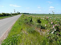
Gedney Marsh is an areas of the Great Fen in Holland, the south-eastern part of Lincolnshire, in which are such hamlets of Gedney parish as [[Gedney Dyke, Dawsmere and Gedney Drove End. The marsh stretches from Gedney itself north-eastwards to the shore of the Wash, between Holbeach Marsh to the west and Lutton Marsh to the south and east.
The fenland south of Gedney is labelled in contrast Gedney Fen.
- Location map: 52°50’34"N, -0°7’60"E

| Gedney and Gedney Marsh, in Lincolnshire |
|---|
|
Gedney • Gedney Broadgate • Gedney Church End • Dawsmere • Gedney Drove End • Gedney Dyke • Gedney Hill • Gedney Marsh |