Menai Bridge: Difference between revisions
mNo edit summary |
|||
| Line 47: | Line 47: | ||
{{reflist}} | {{reflist}} | ||
== | == Outside links == | ||
*[http://menaibridge.org Menai Bridge Website] Menai Bridge Town Partnership Website with details on the news, council, events and businesses of Menai Bridge | *[http://menaibridge.org Menai Bridge Website] Menai Bridge Town Partnership Website with details on the news, council, events and businesses of Menai Bridge | ||
*[http://www.prosiectmenai.co.uk/ Prosiect Menai] A community celebrating the two bridges and the town of Menai Bridge | *[http://www.prosiectmenai.co.uk/ Prosiect Menai] A community celebrating the two bridges and the town of Menai Bridge | ||
*[http://www.geograph.org.uk/search.php?i=3571951 Photos of Menai Bridge and the surrounding area on Geograph] | *[http://www.geograph.org.uk/search.php?i=3571951 Photos of Menai Bridge and the surrounding area on Geograph] | ||
Revision as of 13:46, 21 August 2014
| Menai Bridge Welsh: Porthaethwy | |
| Anglesey | |
|---|---|
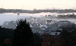
 A view of Menai Bridge | |
| Location | |
| Grid reference: | SH555725 |
| Location: | 53°13’48"N, 4°9’36"W |
| Data | |
| Population: | 3,850 |
| Post town: | Menai Bridge |
| Postcode: | LL59 |
| Dialling code: | 01248 |
| Local Government | |
| Council: | Anglesey |
| Parliamentary constituency: |
Ynys Môn |
| Website: | menaibridge.org |
Menai Bridge is a small town on the Isle of Anglesey. It overlooks the Menai Strait and lies by the Menai Suspension Bridge, built in 1826 by Thomas Telford. It is Anglesey's third largest settlement, with a population of 3,850,[1] Menai Bridge occupies the area of the former parish of Llandysiliogogo, whose former church continues in use as a mortuary chapel (see below).
The village existed as Porthaethwy for many centuries and it still has a house in current use which dates from the 17th century. It is likely that a community has existed at the location of Menai Bridge since Roman times simply because this is the shortest crossing of the Menai Strait. There is a range of buildings including the old court house, a number of old pubs and the buildings associated with the wood-yard (in the process of being converted to houses).
At the eastern edge of the town is Cwm Cadnant Dingle which is now by-passed by a modern bridge constructed in the 1970s. The Afon Cadnant drains into the Menai Strait at this point and this small estuary provides a natural haven for small boats crossing from the mainland. This was the location of the landing stage for the Bishops of Bangor who had their residence at Glyn Garth on Anglesey but whose cathedral was in Bangor on the mainland. Regrettably, the Bishop's palace has been destroyed in recent years and replaced by a block of flats.
There are a number of small islands in the Menai Strait some of which are connected to the town by causeways, including Ynys Faelog, Ynys Gaint and Ynys Castell east of the suspension bridge and Church Island (Ynys Tysilio in Welsh) west of the bridge. The Anglesey Coastal Path passes along the waterfront.
Attractions in Menai Bridge include the 14th-century Church of St Tysilio, St Georges Pier and a butterfly house - Pili Palas.
TV Location
A television company has converted a disused garage into a fake row of shops in the centre of Menai Bridge as a film set for a children's programme Rownd a rownd shown on the Welsh-language channel S4C. They also film the show in the schools in the town, Ysgol y borth and Ysgol David Hughes.
Fair Field
The large car park to the north of the high street is the 'fair field'. This common land is set aside for the holding of an annual fair, which is called Ffair Borth. The fair comes to Menai Bridge on 24 October every year, unless it falls on a Sunday, in which case it is either held on 23 October or 25 October. It takes over the fair field and most of the other roads and streets in the town making passage through the town very difficult. This is an ancient tradition which attracts people from across the island who ignore the usually poor weather to enjoy the traditional fair rides.
Gallery
-
Menai Bridge High Street looking east
-
Cadnant Dingle January 2005
-
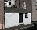
Smallest house in Menai Bridge
-
2.5 second exposure of the Menai Suspension Bridge in the evening
-
The Menai Suspension Bridge from a viewpoint on the A4080 near the Britannia Bridge
References
Outside links
- Menai Bridge Website Menai Bridge Town Partnership Website with details on the news, council, events and businesses of Menai Bridge
- Prosiect Menai A community celebrating the two bridges and the town of Menai Bridge
- Photos of Menai Bridge and the surrounding area on Geograph


