County Donegal: Difference between revisions
Jump to navigation
Jump to search
mNo edit summary |
No edit summary |
||
| Line 12: | Line 12: | ||
|biggest town= | |biggest town= | ||
}} | }} | ||
The '''County of Donegal''' is the northernmost [[Counties of the Republic of Ireland|county]] of the [[Republic of Ireland]]. | |||
'''County Donegal''' is the northernmost [[Counties of the Republic of Ireland|county]] of the [[Republic of Ireland]]. | |||
{{stub}} | {{stub}} | ||
{{Irish county}} | {{Irish county}} | ||
Revision as of 08:26, 11 October 2010
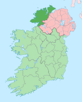
| County Donegal Irish: Contae Dhún na nGall Republic of Ireland | |
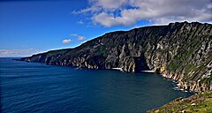
 Slieve League cliffs | |
|---|---|

| |
| [Interactive map] | |
| Province: | Ulster |
| Area: | 1,869 square miles |
| Population: | 147,264 |
| County seat: | Lifford |
The County of Donegal is the northernmost county of the Republic of Ireland.
This county article is a stub: help to improve Wikishire by building it up.
| Counties of the Republic of Ireland |
|---|
|
Carlow • Cavan • Clare • Cork • Donegal • Dublin • Galway • Kerry • Kildare • Kilkenny • Laois • Leitrim • Limerick • Longford • Louth • Mayo • Meath • Monaghan • Offaly • Roscommon • Sligo • Tipperary • Waterford • Westmeath • Wexford • Wicklow |