Template:FP-Rendezvous Bay Pond: Difference between revisions
Jump to navigation
Jump to search
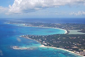
Created page with "{{#switch:{{{1}}} |pic=Anguilla-aerial view western portion.jpg |cap=Rendezvous bay with the pond behind, Anguilla |text='''Rendezvous Bay Pond''', also known as Rendezvous Ba..." |
No edit summary |
||
| Line 4: | Line 4: | ||
|text='''Rendezvous Bay Pond''', also known as Rendezvous Bay Salt Pond, is a shallow, 59-acre brackish lagoon near the south-western end of the main island of [[Anguilla]]. | |text='''Rendezvous Bay Pond''', also known as Rendezvous Bay Salt Pond, is a shallow, 59-acre brackish lagoon near the south-western end of the main island of [[Anguilla]]. | ||
The lagoon, one of several on the island, is an important wetland habitat and denoted as one of the territory’s 'Important Bird Areas'.}}<noinclude>{{ | The lagoon, one of several on the island, is an important wetland habitat and denoted as one of the territory’s 'Important Bird Areas'.}}<noinclude>{{FP data}} | ||
Latest revision as of 09:02, 9 May 2021
 |
Rendezvous Bay PondRendezvous Bay Pond, also known as Rendezvous Bay Salt Pond, is a shallow, 59-acre brackish lagoon near the south-western end of the main island of Anguilla. The lagoon, one of several on the island, is an important wetland habitat and denoted as one of the territory’s 'Important Bird Areas'. (Read more) |