Barmeen: Difference between revisions
Jump to navigation
Jump to search
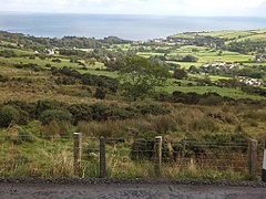
Created page with "{{Infobox townland |name=Barmeen |county=Antrim |picture=Fields and scrub in Glendun by Barmeen - geograph-3161983.jpg |picture caption=Fields and scrub in Glendun by Barmeen..." |
No edit summary |
||
| Line 15: | Line 15: | ||
|website= | |website= | ||
}} | }} | ||
'''Barmeen''' is a rural [[townland]] in the [[Antrim Hills]] | '''Barmeen''' is a rural [[townland]] in the [[Antrim Hills]] of [[County Antrim]], located at the foot of [[Glendun]], one of the nine [[Glens of Antrim]], west of [[Cushendun]] and north of [[Knocknacarry]]. It is within the [[Barony of Cary]]. | ||
The name derives from the Irish ''Barr min'', meaning "Smooth top".<ref>{{cite web|title=Barmeen|work=Place Names NI|url=http://www.placenamesni.org/historicforms.php?getPnameId=18437|accessdate=10 May 2013}}</ref> | The name derives from the Irish ''Barr min'', meaning "Smooth top".<ref>{{cite web|title=Barmeen|work=Place Names NI|url=http://www.placenamesni.org/historicforms.php?getPnameId=18437|accessdate=10 May 2013}}</ref> | ||
Latest revision as of 22:18, 31 October 2017
| Barmeen TOWNLAND | |
| County Antrim | |
|---|---|
 Fields and scrub in Glendun by Barmeen | |
| Location | |
| Location: | 55°7’34"N, 6°4’16"W |
| Grid reference: | D231327 |
| Data | |
Barmeen is a rural townland in the Antrim Hills of County Antrim, located at the foot of Glendun, one of the nine Glens of Antrim, west of Cushendun and north of Knocknacarry. It is within the Barony of Cary.
The name derives from the Irish Barr min, meaning "Smooth top".[1]
References
- ↑ "Barmeen". Place Names NI. http://www.placenamesni.org/historicforms.php?getPnameId=18437. Retrieved 10 May 2013.