Sedgwick, Westmorland: Difference between revisions
Jump to navigation
Jump to search
Created page with "{{Infobox town |name=Sedgwick |county=Westmorland |picture=Sedgwick village - geograph.org.uk - 503249.jpg |picture caption=Sedgwick village |os grid ref=SD508878 |latitude=54..." |
No edit summary |
||
| Line 26: | Line 26: | ||
*{{brithist|49314|Sedgwick}} | *{{brithist|49314|Sedgwick}} | ||
*[http://www.sedgwick.org/na/misc/seggeswickvillage-1600s.html Sedgwick.org] | *[http://www.sedgwick.org/na/misc/seggeswickvillage-1600s.html Sedgwick.org] | ||
*[http://www.matthewpemmott.co.uk/2010/07/sedgwick-gunpowder-works-nr-sedgwick.html] | *[http://www.matthewpemmott.co.uk/2010/07/sedgwick-gunpowder-works-nr-sedgwick.html Castles, Towers and fortified Buildings: Sedgwick] | ||
==References== | ==References== | ||
{{Reflist}} | {{Reflist}} | ||
Latest revision as of 20:23, 22 September 2017
| Sedgwick | |
| Westmorland | |
|---|---|
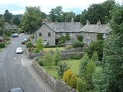
 Sedgwick village | |
| Location | |
| Grid reference: | SD508878 |
| Location: | 54°16’48"N, 2°44’46"W |
| Data | |
| Population: | 349 (2011) |
| Post town: | Kendal |
| Postcode: | LA8 |
| Dialling code: | 015395 |
| Local Government | |
| Council: | Westmorland & Furness |
| Parliamentary constituency: |
Westmorland and Lonsdale |
Sedgwick is a village in the south of Westmorland, four and a half miles south of Kendal. Its main point of interest is Sedgwick House, built in 1868 by Paley and Austin for the industrialist William Henry Wakefield.
The village is on the route of the Lancaster Canal. Sizergh Castle and Garden and Levens Hall are just west of the village.
The gunpowder works in Sedgwick, powered by water from the River Kent, operated from 1857 to 1935 and was probably the cause of the rapid expansion of the village in the Victorian era.
Outside links
| ("Wikimedia Commons" has material about Sedgwick, Westmorland) |
