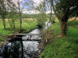
Cunsey Beck: Difference between revisions
Created page with "right|thumb|300px|Cunsey Beck {{county|Lancashire}} '''Cunsey Beck''' is one of several rivers and streams that replenish Windermere, the largest..." |
mNo edit summary |
||
| Line 8: | Line 8: | ||
==Location== | ==Location== | ||
*Location map:{{wmap|54.3343|-2.948}} | *Location map:{{wmap|54.3343|-2.948|zoom=14}} | ||
[[Category:Rivers of Lancashire]] | [[Category:Rivers of Lancashire]] | ||
Latest revision as of 18:58, 13 May 2017

Cunsey Beck is one of several rivers and streams that replenish Windermere, the largest of the waters of the Lake District. The beck flows from the Furness Fells of Lancashire on the west side of the lake.
The beck is just over two miles long and generally slow flowing. It descends some 87 feet from the southern end of Esthwaite Water, which it drains, to the western banks of Windermere near a lake island called Ling Holm.
After flowing out of Esthwaite Water the Cunsey Beck replenishes the small Out Dubs Tarn. Draining the tarn at its southern end the beck then flows in a south-easterly direction between the conifer-wooded slopes of Grizedale Forest to the south and west and the deciduous woodland of Bishop Woods to the north. Just before entering Windermere the beck passes through the deciduous Cunsey Wood. Immediately before entering the lake it is crossed by a footbridge which is part of a public footpath along a stretch of the western shore of Windermere.
Location
- Location map:54°20’3"N, 2°56’53"W