Preseli: Difference between revisions
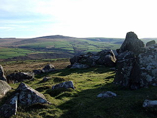
Created page with 'right|thumb|320px|Carn Edward with view to Cerrig Lladron, Preseli '''Preseli''' or the ''' Prescelly Hills''' is a range of hills in northern [[Pembrokeshir…' |
|||
| Line 78: | Line 78: | ||
*[http://www.themodernantiquarian.com/site/3878/preseli_mountains.html Preseli at The Modern Antiquarian] | *[http://www.themodernantiquarian.com/site/3878/preseli_mountains.html Preseli at The Modern Antiquarian] | ||
[[Category:Mountains and hills]] | [[Category:Mountains and hills]] [[Category:Pembrokeshire]] | ||
Latest revision as of 23:33, 3 November 2011

Preseli or the Prescelly Hills is a range of hills in northern Pembrokeshire. They are all within the Pembrokeshire Coast National Park.
The hills rise to 1,760 feet above sea level at Foel Cwmcerwyn, the highest hill of the group and the highest of Pembrokeshire, and they are dotted with prehistoric remains including evidence of Neolithic settlement.
In 1923, the petrologist Herbert Henry Thomas identified that bluestone from the hills corresponded to that used to build the inner circle of Stonehenge.[1] More recent geologists have specifically identified Carn Menyn, sometimes called Carn Meini, as one of the bluestone sources.[2]
Slate quarrying was once big business in the Preseli Hills and remnants of the quarries can still be seen in Rosebush, Pembrokeshire and there is a slate workshop today still at Llangolman where authentic Welsh slate is still used in a variety of craft items.
During the Second World War, the War Office used the Preseli Hills for training exercises. Its continued use for training exercises following the war was the subject of protest.
Historic sites
Historic sites of interest in the Preseli Mountains include:
|
|
|
|
|
References
- ↑ Thomas, H.H. 1923. The source of the stones of Stonehenge. Antiquaries Journal 3, 239-260.
- ↑ Archaeologists Figure Out Mystery of Stonehenge Bluestones