Romannobridge: Difference between revisions
Jump to navigation
Jump to search
Created page with "{{Infobox town |name=Romannobridge |county=Peeblesshire |picture=Romannobridge - geograph.org.uk - 1711591.jpg |picture caption=Romannobridge |os grid ref=NT160480 |latitude=5..." |
No edit summary |
||
| Line 15: | Line 15: | ||
|website= | |website= | ||
}} | }} | ||
'''Romannobridge''' is a village | '''Romannobridge''' is a village in the parish of [[Newlands, Peeblesshire|Newlands]] in [[Peeblesshire]]. It is situated where the [[Lyne Water]] is crossed by the A701 road. | ||
Villages nearby include [[West Linton]], [[Hallyne]], [[Dolphinton]], [[Blyth Bridge]], and [[Mountain Cross, Peeblesshire|Mountain Cross]]. | Villages nearby include [[West Linton]], [[Hallyne]], [[Dolphinton]], [[Blyth Bridge]], and [[Mountain Cross, Peeblesshire|Mountain Cross]]. | ||
Latest revision as of 19:16, 28 November 2016
| Romannobridge | |
| Peeblesshire | |
|---|---|
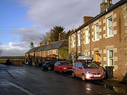
 Romannobridge | |
| Location | |
| Grid reference: | NT160480 |
| Location: | 55°43’7"N, 3°20’15"W |
| Data | |
| Post town: | West Linton |
| Postcode: | EH46 |
| Local Government | |
| Council: | Scottish Borders |
Romannobridge is a village in the parish of Newlands in Peeblesshire. It is situated where the Lyne Water is crossed by the A701 road.
Villages nearby include West Linton, Hallyne, Dolphinton, Blyth Bridge, and Mountain Cross.
Outside links
| ("Wikimedia Commons" has material about Romannobridge) |
