Maxworthy: Difference between revisions
Jump to navigation
Jump to search
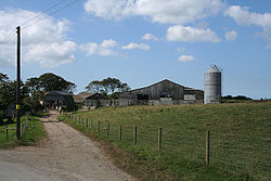
Created page with "{{Infobox town |name=Maxworthy |county=Devon |picture=North Petherwin, barns at Maxworthy - geograph.org.uk - 556927.jpg |picture caption=Barns at Maxworthy |os grid ref=SX256..." |
No edit summary |
||
| Line 9: | Line 9: | ||
|population= | |population= | ||
|census year= | |census year= | ||
|post town= | |post town=Launceston | ||
|postcode= | |postcode=PL15 | ||
|dialling code= | |dialling code= | ||
|LG district=Cornwall | |LG district=Cornwall | ||
}} | }} | ||
'''Maxworthy''' is a hamlet in western [[Devon]], within the part of that county which extends a finger to the west of the [[River Tamar]], surrounded on three sides by [[Cornwall]]. It is found to the north of [[North Petherwin]]. | '''Maxworthy''' is a hamlet in western [[Devon]], within the part of that county which extends a finger to the west of the [[River Tamar]], surrounded on three sides by [[Cornwall]]. It is found to the north of [[North Petherwin]], in the county's [[Black Torrington Hundred]]. | ||
==References== | ==References== | ||
Latest revision as of 12:43, 9 July 2020
| Maxworthy | |
| Devon | |
|---|---|
 Barns at Maxworthy | |
| Location | |
| Grid reference: | SX256930 |
| Location: | 50°42’36"N, 4°28’19"W |
| Data | |
| Post town: | Launceston |
| Postcode: | PL15 |
| Local Government | |
| Council: | Cornwall |
Maxworthy is a hamlet in western Devon, within the part of that county which extends a finger to the west of the River Tamar, surrounded on three sides by Cornwall. It is found to the north of North Petherwin, in the county's Black Torrington Hundred.
References

This Devon article is a stub: help to improve Wikishire by building it up.