Plymouth Hoe: Difference between revisions
m clean up, typos fixed: graet → great |
|||
| Line 31: | Line 31: | ||
Plymouth Hoe is perhaps best known for the story that Sir Francis Drake a famous game of bowls here in 1588 while waiting for the tide to change before sailing out with the English fleet to engage with the Spanish Armada. The British Library holds a [http://www.bl.uk/onlinegallery/onlineex/unvbrit/a/zoomify82820.html 1591 Spry map of Plimmouth] from this era. | Plymouth Hoe is perhaps best known for the story that Sir Francis Drake a famous game of bowls here in 1588 while waiting for the tide to change before sailing out with the English fleet to engage with the Spanish Armada. The British Library holds a [http://www.bl.uk/onlinegallery/onlineex/unvbrit/a/zoomify82820.html 1591 Spry map of Plimmouth] from this era. | ||
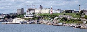
[[File:Royal Citadel, Plymouth.jpg|right|thumb| | [[File:The Royal Citadel, Plymouth from Mount Batten.jpg|right|thumb|300px|The Royal Citadel on the Hoe]] | ||
A Tudor fortress guarded the neck of water between the eastern Hoe and [[Mount Batten]] and some sheer granite and limestone cannon points remain, however in the late 1660s, following The Restoration, a massive star-shaped stone fortress known as the [[Royal Citadel, Plymouth|Royal Citadel]], was constructed to replace it.<ref>{{pevsner}}</ref> It remains occupied by the army. | A Tudor fortress guarded the neck of water between the eastern Hoe and [[Mount Batten]] and some sheer granite and limestone cannon points remain, however in the late 1660s, following The Restoration, a massive star-shaped stone fortress known as the [[Royal Citadel, Plymouth|Royal Citadel]], was constructed to replace it.<ref>{{pevsner}}</ref> It remains occupied by the army. | ||
Revision as of 20:23, 7 July 2016
| Plymouth Hoe | |
| Devon | |
|---|---|
 Plymouth Hoe from Mount Batten | |
| SX477538 50°21’53"N, 4°8’31"W | |
Plymouth Hoe, referred to locally as the Hoe, is a broad, low hill looking over Plymouth Sound in the City of Plymouth in Devon. On the top of the Hoe stands the Royal Citadel, on the eastern side, and the west large south-facing open public space. Its face to the sea is a low limestone cliff forming the city's seafront
The name derives from the Old English word hoh, meaning 'heel' which was used to describe a sloping hill shaped like an inverted heel.
The Hoe once separates old Plymouth into two very distinct towns, Sutton to the east and Stonehouse to the west, with the third town, Devonport upstream on the Hamoaze. Though the townscape has grown and spread behind the Hoe and indeed up its northern slopes, the bulk of the Hoe is still the great division to seaward.
From the top of the Hoe there are views over Plymouth Sound, Drake's Island, and across the Hamoaze to Mount Edgcumbe in Cornwall.
History
Until the early 17th century large outline images of the giants Gog and Magog (or Goemagot and Corineus) had for a long time been cut into the turf of the Hoe exposing the white limestone beneath.[1][2] These figures were periodically re-cut and cleaned.[3]</ref> No trace of them remains today, but this likely commemorates the Cornish foundation myth, being the point, Lam Goemagot – the Giant's Leap - from which the Giant was cast into the sea by the hero Corin.[4]
Plymouth Hoe is perhaps best known for the story that Sir Francis Drake a famous game of bowls here in 1588 while waiting for the tide to change before sailing out with the English fleet to engage with the Spanish Armada. The British Library holds a 1591 Spry map of Plimmouth from this era.

A Tudor fortress guarded the neck of water between the eastern Hoe and Mount Batten and some sheer granite and limestone cannon points remain, however in the late 1660s, following The Restoration, a massive star-shaped stone fortress known as the Royal Citadel, was constructed to replace it.[5] It remains occupied by the army.

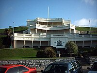
From 1880 there was a popular bandstand on the Hoe. It was removed for scrap metal during the Second World War and never rebuilt.[6] A three tier belvedere built in 1891 survives;[7] it was built on the site of a camera obscura]], probably built in the 1830s, which showed views of the harbour.[8] Below this site was the Bull Ring (now a memorial garden),[7] and a grand pleasure pier, started in 1880, which provided a dance hall, refreshment, promenading and a landing place for boat trips.[9] The pier was destroyed by German bombing in Second World War.
There is an imposing series of Victorian terraces to the west of the naval memorial which previously continued to the Grand Hotel and, until it was destroyed by bombing, the grand clubhouse of the Royal Western Yacht Club. The club then merged with the Royal Southern and occupied that club's older premises which it had created from the regency public steam baths by the basin at West Hoe before the rejuvenated club moved in the late 1980s to Queen Anne Battery.
Landmarks

A prominent landmark on the Hoe is Smeaton's Tower. This is the upper portion of John Smeaton's Eddystone Lighthouse, which was originally built on the Eddystone Rocks 14 miles south of here in 1759. It was dismantled in 1877 and moved, stone by stone, to the Hoe where it was re-erected.[10]
Smeaton's Tower overlooks Tinside Pool, an unusual 1930s outdoor lido which sits upon the limestone shoreline at the base of the cliff. Most of the works to create the swimming areas and Madeira Road were carried out to make work for the local unemployed during the Depression. Long abandoned and smashed by the seas over many years, the Lido has been largely restored, though it does not see much use.
A statue of Sir Francis Drake by Joseph Boehm (a copy of the original statue, which stands in his home town, Tavistock) was placed on the Hoe in 1884 to commemorate the great captain.[11] There are also several war memorials along the northern side of the Hoe. The largest commemorates the Royal Naval dead of the two world wars; its central obelisk is by Robert Lorimer and was unveiled in 1924, while the surrounding sunken garden was added by Edward Maufe in 1954.[11][12]
The Hoe also includes a long broad tarmacked promenade (currently a disabled motorists car park) which serves as a spectacular military parade ground and which is often used for displays by Plymouth-based Royal Navy, Royal Marines, the Army garrison, as well as for travelling funfairs and open-air concerts.
Set into the shape of the southern sea facing fortifications of the Royal Citadel, Plymouth|Royal Citadel is the Citadel Hill Laboratory of the Marine Biological Association of the UK, which also houses the Sir Alister Hardy Foundation for Ocean Science. Below and to the east, perched on the rocky foreshore is the clubhouse of the Royal Plymouth Corinthian Yacht Club.
Tourism
The Hoe is a popular area for Plymothians and visitors. There is always a great deal of activity on the water, including frequent warship movements, ferries going and coming from France and Spain, fishing trawlers and a swarm of larger and smaller sailing boats. The Fastnet yacht race ends here. The annual two-day British Firework Championships attracts tens of thousands of spectators.
For forty years, there has been controversy about development on the edges of the Hoe green space. The erection of two discount hotel chain box buildings, at the southern end of Armada Way and the other at the Sound end of Leigham Street, contrast with their Victorian surroundings. The former Grand Hotel has been converted into apartments[13] and the long derelict yacht club site has now been filled by a modern block of flats. The Plymouth Dome, a turreted and domed building, built into a small old quarry site above Tinside as an historical theme tourist attraction,[14] has failed to thrive.[15]

In literature and popular culture
The Hoe is inseparable from the legend of Drake playing bowls before the approach of the Spanish Armada. Drake, a Devon man himself, had established the Royal Navy's presence at Plymouth. The legend tells that Drake and the other captains were playing bowls on Plymouth Hoe when a messenger ran up with the news that the Spanish Armada had been signed in the Channel. As the captains moved to hurry to their ships, Drake is said to have stopped them with the words "We have time enough to finish this game and beat the Spaniards too!"
The romance of Drake and the Armada is played upon in Henry Newbolt's famous poem Drake's Drum, which invokes the Hoe in each of its verses, beginning:
Drake he's in his hammock an' a thousand mile away,
(Capten, art tha sleepin' there below?)
Slung atween the round shot in Nombre Dios Bay,
An' dreamin' arl the time o' Plymouth Hoe.
Outside links
References
- ↑ Gray, Todd (2003). Lost Devon: Creation, Change and Destruction over 500 Years. Exeter, Devon: The Mint Press. pp. 153. ISBN 1-903356-32-6.
- ↑ An early and explicit reference is made in Richard Carew (1602), The Survey of Cornwall, text here:[1]. Note that Carew refers to Plymouth Hoe as "the Hawe at Plymmouth".
- ↑ Bracken, C. W.: A History of Plymouth and her Neighbours (1931), page 4
- ↑ Geoffrey of Monmouth, Historia Regum Britanniae 1.12–16
- ↑ Nikolaus Pevsner: The Buildings of England: Devon, 1952; 1989 Penguin Books ISBN 978-0-300-09596-8
- ↑ Moseley, Brian (May 2011). "Hoe Bandstand". Plymouth Data. Archived from the original on 28 September 2013. https://web.archive.org/web/20130928230446/http://www.plymouthdata.info/Hoe%20Bandstand.htm. Retrieved 13 February 2015.
- ↑ 7.0 7.1 Moseley, Brian (October 2011). "Plymouth, Belvedere and Bull Ring". Plymouth Data. Archived from the original on 28 September 2013. https://web.archive.org/web/20130928225758/http://www.plymouthdata.info/Belvedere.htm. Retrieved 13 February 2015.
- ↑ Moseley, Brian (May 2011). "Camera Obscura". Plymouth Data. Archived from the original on 28 September 2013. https://web.archive.org/web/20130928225830/http://www.plymouthdata.info/Camera%20Obscura.htm. Retrieved 13 February 2015.
- ↑ Moseley, Brian (January 2011). "Plymouth, Promenade Pier". Plymouth Data. Archived from the original on 7 August 2013. https://web.archive.org/web/20130807172112/http://www.plymouthdata.info/Promenade%20Pier.htm. Retrieved 13 February 2015.
- ↑ "Eddystone Lighthouse". Trinity House. http://www.trinityhouse.co.uk/interactive/gallery/eddystone.html. Retrieved 6 September 2006.
- ↑ 11.0 11.1 Nikolaus Pevsner: The Buildings of England: Devon, 1952; 1989 Penguin Books ISBN 978-0-300-09596-8
- ↑ Moseley, Brian. "Plymouth, Naval War Memorial". Plymouth Data. Archived from the original on 11 October 2007. http://web.archive.org/web/20071011221850/http://www.plymouthdata.info/Memorial-Naval+War.htm. Retrieved 2 March 2008.
- ↑ "£8million restoration work begins on Grand Hotel". Plymouth Herald. 16 March 2009. http://www.thisisplymouth.co.uk/news/8million-restoration-work-begins-Grand-Hotel/article-773035-detail/article.html. Retrieved 4 May 2010.
- ↑ Rowe, Mark (5 December 2004). "Family Outings: Plymouth Dome". The Independent (London). http://www.independent.co.uk/travel/uk/family-outings-plymouth-dome-678495.html. Retrieved 4 May 2010.
- ↑ "Chef's excitement as he unveils Rhodes @ The Dome in Plymouth". Plymouth Herald. 24 January 2013. http://www.thisisdevon.co.uk/Chef-s-excitement-unveils-Rhodes-Dome-Plymouth/story-17946392-detail/story.html#axzz2UcFhEL4D. Retrieved 28 May 2013.