Gatwick Village: Difference between revisions
Jump to navigation
Jump to search
Created page with ':''For the airport, which is not near the village, see Gatwick Airport '' {{Infobox town |name=Gatwick |county=Surrey |picture=gatwickvillagewaverley.jpg |picture caption=Ga…' |
No edit summary |
||
| Line 1: | Line 1: | ||
{{hatnote|For the airport, which is not near the village, see [[Gatwick Airport]]}} | |||
{{Infobox town | {{Infobox town | ||
|name=Gatwick | |name=Gatwick | ||
Latest revision as of 17:15, 7 December 2015
For the airport, which is not near the village, see Gatwick Airport
| Gatwick | |
| Surrey | |
|---|---|
 Gatwick village | |
| Location | |
| Grid reference: | SU915448 |
| Location: | 51°11’44"N, -0°41’28"W |
| Data | |
| Local Government | |
| Council: | Waverley |
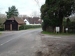
Gatwick is a small and unspoilt village in south-western Surrey. It lies to near the villages of Puttenham, Charleshill, Elstead and Peper Harrow. The village lies close to the Puttenham & Crooksbury Commons.
The village sits surrounded by woodland in the North Downs, less than half a mile from the meanders of the River Wey, beyond which lies Elstead, while half a mile to the north is the Tarn, the largest and lowest of a string of long, thin ponds formed from the course of a bourn running off the Hog's Back down to the Wey.
Of the village's noisy namesake, Gatwick Airport, there is no sign and no connection as it merely coincidentally named and lies elsewhere in Surrey.
Outside links
| ("Wikimedia Commons" has material about Gatwick Village) |
