Blewbury: Difference between revisions
Created page with '{{Infobox town |name=Blewbury |county=Berkshire |picture=View down the edge - geograph.org.uk - 1369370.jpg |picture caption=Blewbury |os grid ref=SU5385 |latitude=51.571 |longit…' |
mNo edit summary |
||
| Line 16: | Line 16: | ||
|website=[http://www.blewbury.co.uk Blewbury Bulletin] | |website=[http://www.blewbury.co.uk Blewbury Bulletin] | ||
}} | }} | ||
'''Blewbury''' is a village in north- | '''Blewbury''' is a village in north-eastern [[Berkshire]] at the foot of the [[Berkshire Downs]] about 2½ miles south of [[Didcot]]. | ||
It is an interestingly wrought village, set in a ring and in which many of the houses are set back within the ring along little lanes. | It is an interestingly wrought village, set in a ring and in which many of the houses are set back within the ring along little lanes. | ||
Latest revision as of 12:58, 27 January 2016
| Blewbury | |
| Berkshire | |
|---|---|
 Blewbury | |
| Location | |
| Grid reference: | SU5385 |
| Location: | 51°34’16"N, 1°13’48"W |
| Data | |
| Population: | 1,528 (2001) |
| Post town: | Didcot |
| Postcode: | OX11 |
| Dialling code: | 01235 |
| Local Government | |
| Council: | Vale of White Horse |
| Parliamentary constituency: |
Wantage |
| Website: | Blewbury Bulletin |
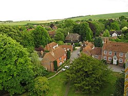
Blewbury is a village in north-eastern Berkshire at the foot of the Berkshire Downs about 2½ miles south of Didcot.
It is an interestingly wrought village, set in a ring and in which many of the houses are set back within the ring along little lanes.
Parish church
The Church of England parish church of Saint Michael the Archangel was originally an early Norman building of the 11th century. St Michael's is now a member of the Churn Benefice.[1]
Buildings about the village
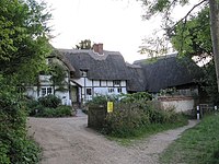
Blewbury has a number of historic timber-framed buildings.[2] There is a cruck cottage in South Street.[3] Hall Barn may date from about 1660.[3]
William Malthus was a London merchant who left land at Noke, Oxfordshire to fund a school at Blewbury.[4][5] Its five-bay Queen Anne style school building close to St. Michael's church was built in 1709.[2]
Also close to the church are two almshouses. Nikolaus Pevsner states that he first was built in 1738 for the oldest man in the village and the second was added on its centenary in 1838.[2] However, Page and Ditchfield state that there are two cottages that one James Bacon founded in 1747.[4]
Prehistoric remains

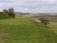
The southern part of the parish is chalk downland and includes a number of prehistoric sites. Half of the 360-foot high Blewburton Hill is in the parish. It is topped by an Iron Age hill fort that may have been occupied from the 4th century BC to the 1st century BC.[6]
The parish's highest point is the Churn Hill at 520 feet, a mile and a half southwest of the village. On its northwestern side are two round barrows, the larger of which is Churn Knob.[3] There are other round barrows further south, towards the boundaries with Compton and East Ilsley parishes.[3]
References

Sources
- Page, W.H.; Ditchfield, P.H., eds (1923). A History of the County of Berkshire, Volume 3. Victoria County History. pp. 280–291.
- Pevsner, Nikolaus (1966). Berkshire. The Buildings of England. Harmondsworth: Penguin Books. pp. 91–92.
Outside links
| ("Wikimedia Commons" has material about Blewbury) |
