Stratford, Essex: Difference between revisions
Created page with '{{Infobox town |name=Stratford |county=Essex |picture=Stratford Broadway.JPG |picture caption=Stratford Broadway |post town=London |postcode=E15 |dialling code=020 |os grid ref=T…' |
|||
| Line 85: | Line 85: | ||
*[http://historyofstratford.co.uk/ History of Stratford site with links to historic Post Office directories] | *[http://historyofstratford.co.uk/ History of Stratford site with links to historic Post Office directories] | ||
*[http://www.discover.org.uk/ The Discover Centre] | *[http://www.discover.org.uk/ The Discover Centre] | ||
[[Category:Metropolitan Essex]] | |||
Revision as of 11:29, 25 January 2016
| Stratford | |
| Essex | |
|---|---|
 Stratford Broadway | |
| Location | |
| Grid reference: | TQ385845 |
| Location: | 51°32’32"N, 0°0’0"E |
| Data | |
| Post town: | London |
| Postcode: | E15 |
| Dialling code: | 020 |
| Local Government | |
| Council: | Newham |
| Parliamentary constituency: |
West Ham |
Stratford, historically known as Stratford Langthorne, is a town in Essex within the metropolitan conurbation. The town is one of a pair of Stratfords facing each other across the River Lea, as Bow in Middlesex used to be called Stratford-atte-Bow, both towns being named after the Roman road passing through them.
The town
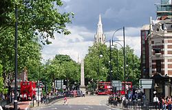
The middle of the town is along Broadway, where the mains shops and offices are found, the pubs and restaurants, the Old Town Hall and the parish church, St John's. The mouth of the Broadway Shopping Centre is here too, its rear entrance opening on the plaza in front of Stratford Station. Broadway lives up to its name, the two sides divided by a major road and pedestrianised road between which on island stands the church. The town centre lies in an island created by the vast ring road cast around it in the 1960s.
The High Street runs to the west of Broadway; much beyond the Broadway it is no longer a high street as such but the long dual carriageway of the A11 fronted by housing, some beleaguered shops and office and industrial units, until the Lea and the canals which shadow it. Running north from the ring road was Carpenter's Road, a place of industrial yards and council housing, until the Olympic developments closed the yards and factories in order to create temporary employment for builders.
The main road, the A11 out of London, is formed by the High Street before being thrown into a ring road around the town centre, Broadway carrying the westbound traffic and the eastbound reaches round the back of the town before the station.
New Stratford is the area to the north developed in the nineteenth century, broadly the area between the Leytonstone Road and the “raillands” now being developed with Olympic and Legacy development in mind. It is largely an area of housing with industrial units.
Stratford is one of the major centres identified in the "London Plan".[1]
Stratford is adjacent to the London Olympic Park and is currently experiencing inward investment and expansion linked to the expectations generated by the forthcoming 2012 Summer Olympics to be held there. An entirely new district of the town, dubbed "Stratord City" is to be created out of the athletes' village after the fortnight's sport is done.
Economy
Stratford's existing shopping centre is conveniently located opposite the station, and is popular for its range of accessibly-priced stores, its indoor and outdoor market stalls, and the 'inshops' network of small retail outlets. The centre occupies much of the 'island site' created in the 1960s by the surrounding gyratory traffic system. When Stratford City's vast shopping destination opens on the other side of Stratford Station in 2011, a direct pedestrian bridge is planned to span the road and railway lines, connecting the two centres.
Name of the town
Stratford's name is first recorded in 1067 as Strætforda, and means "Street ford" (ford on the Roman road).[2] The ford, long sinced bridged, crossed the branches of the River Lea on the London to Colchester road to the west of the town.[2] The nearby town of Bow, across the Lea in Middlesex, was also known as Stratford and a variety of suffixes were used to distinguish the two.[2] The settlement to the east of the Lea was also known as Estratford refererring to the location east of the other Stratford, Statford Hamme alluding to the location within the parish of West Ham, with Abbei Stratford and Stretford Langthorne both referring to the presence of Stratford Langthorne Abbey.[2]
The theatre here, "The Theatre Royal Stratford East" was opened in 1884, and makes play of the coincidental name of Shakespeare's home, Stratford upon Avon in Warwickshire.
Place amonst the surrounding towns
Stratford is found at the western edge of Essex. To the north is Leyton and eastward is Forest Gate. West Ham is to the southeast and Plaistow to the south. Further west in Middlesex lie Bow and Hackney Wick.
The River Lea and the complex network of Bow Back Rivers mark the western limits of the town's area.
History
Stratford was historically a faming village in the parish of West Ham. A monastery was found here during the Middle Ages.
The railway came to Stratford in 1839 and this transformed the village into an industrial town. The introduction of the railway at Stratford in 1839 caused a focus of activity within the fast-expanding Stratford New Town.
As part of the urban growth spreading out from London in the late 19th century, Stratford and its neighbouring towns and villages grew significantly and increased in population. A new town hall for the Borough of West Ham was built here in 1886, soon to become a "County Borough", a status allowed to major towns.
In 1884 the "Theatre Royal Stratford East" was opened. It gained fame in the 1950s under its Manager Gerry Raffles (1928-1975), after whom Gerry Raffles Square is named, and Joan Littlewood as its Artistic Director for 26 years.
More recently there has been a move away from railway works and heavy industry towards becoming a significant commercial and cultural centre, not always successful, and the biggest employers remain those in the public sector or funded by taxpayers' money, discouraging enterprise.
Redevelopment

Stratford has been a focus of regeneration for some years, and is the location of a number of major projects:
- Westfield Stratford City is a multi-billion pound scheme to regenerate the 73-hectare brownfield railway lands to the north of the existing town centre. There will be a vast shopping centre similar in size to Bluewater. Nearby will be a new purpose-built community of 5,000 homes, offices, schools, public spaces, municipal and other facilities, all intened to become a major metropolitan centre for Southwest Essex.
- The 2012 Olympic and Paralympic Games will have their main base at the Olympic Park, which will contain a significant number of venues including the Olympic Stadium, Aquatics Centre, and London Velopark. Some of the new Stratford City accommodation will serve as the Olympic Village housing athletes before being re-configured for the property market. After the Olympics the 'legacy' plans include the largest new urban park for over a century, and a new university.
Transport
Stratford is a significant transport hub. Stratford station is on the National Rail network on the Great Eastern Main Line; it is the eastern terminus of the North London Line; and is on a secondary branch of the Lea Valley Lines. It has local rail services towards Richmond and Clapham Junction (London Overground) and commuter and inter-regional services to London Liverpool Street and rural Essex. The Central Line of London Underground serves the station, and it is the eastern terminus of the Jubilee Line. The Docklands Light Railway currently serves the station on a route towards Canary Wharf and Lewisham.
Nearby is Stratford International station, to the northwest; the station is served by domestic high speed services and there is provision for international Eurostar services from St Pancras to eventually call at the station. The two stations are planned to be linked by a new branch of the Docklands Light Railway which will also serve a new station at Stratford High Street]].
A bus station stands by the main station with routes into London.
The eastern part of Stratford is served by Maryland railway station. The stopping rail services between Liverpool Street and Shenfield, which call at Stratford and Maryland, are planned to be incorporated into the Crossrail service.
Culture

Stratford's Cultural Quarter, adjacent to the shopping centre, is home to several arts venues, bars and cafés:
- Theatre Royal Stratford East
- Stratford Circus
- The Discover Centre for children is a partner in the Cultural Quarter
- The Stratford Rex nightclub occupies a building which opened in 1896 as the Borough Theatre and Opera House. It was known as the Rex Cinema from 1933 to 1969, before being converted to a live music venue.
References
- ↑ Mayor of London (February 2008). "London Plan (Consolidated with Alterations since 2004)". Greater London Authority. http://www.london.gov.uk/thelondonplan/docs/londonplan08.pdf.
- ↑ 2.0 2.1 2.2 2.3 Mills, D. (2000). Oxford Dictionary of London Place Names. Oxford.
Outside links
| ("Wikimedia Commons" has material about Essex Stratford, Essex) |
