Carnbo: Difference between revisions
Jump to navigation
Jump to search
Created page with "{{Infobox town | county=Kinross-shire | name=Carnbo | gaelic= | scots= | picture=Carnbo.jpg | picture caption= | population= | os grid ref= | longitude=-3.526022 | latitude=5..." |
No edit summary |
||
| Line 17: | Line 17: | ||
}} | }} | ||
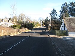
'''Carnbo''' is a village in the parish of [[Fossoway]], [[Kinross-shire]], on South Queich Water, adjacent to the boundary with [[Perthshire]], 4½ miles west of the [[county town]] [[Kinross]]. | '''Carnbo''' is a village in the parish of [[Fossoway]], [[Kinross-shire]], on South Queich Water, adjacent to the boundary with [[Perthshire]], 4½ miles west of the [[county town]] [[Kinross]]. | ||
[[File:Carnbo Hall - geograph.org.uk - 278052.jpg|thumb|left|Carnbo Hall: The former primary school at Carnbo, now the village hall]] | |||
{{stub}} | |||
Revision as of 10:10, 25 October 2014
| Carnbo | |
| Kinross-shire | |
|---|---|

| |
| Location | |
| Location: | 56°12’43"N, 3°31’34"W |
| Data | |
| Post town: | Kinross |
| Postcode: | KY13 |
| Dialling code: | 01577 |
| Local Government | |
| Council: | Perth and Kinross |
| Parliamentary constituency: |
Ochil and South Perthshire |
Carnbo is a village in the parish of Fossoway, Kinross-shire, on South Queich Water, adjacent to the boundary with Perthshire, 4½ miles west of the county town Kinross.

This Kinross-shire article is a stub: help to improve Wikishire by building it up.