Loch Maberry: Difference between revisions
Created page with 'right|thumb|300px|Loch Marberry Loch Maberry is a modest freshwater loch which lies across the border of Wigtownshire wit…' |
|||
| Line 11: | Line 11: | ||
{{commons}} | {{commons}} | ||
{{DEFAULTSORT:Maberry Loch}} | |||
[[Category:Lochs of Ayrshire]] [[Category:Lochs of Wigtownshire]] | [[Category:Lochs of Ayrshire]] [[Category:Lochs of Wigtownshire]] | ||
Revision as of 18:19, 10 March 2014

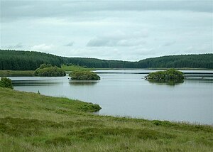
Loch Maberry is a modest freshwater loch which lies across the border of Wigtownshire with Ayrshire at NX285751. It is found immediately southwest of Loch Dornal, the two separated by a narrow tongue carrying the road, and both lochs sit on the county border. Almost the whole shore of Loch Maberry is within the forest.
Loch Maberry is the source of the River Bladnoch.
Loch Maberry Castle
A ruined fortress stands on a rock in the midst of the loch. Loch Maberry Castle is a fortified island, a crannog, surrounded by the remains of a massive drystone wall, 6 to 7 feet thick and about 7 feet high, enclosing an area approx 112 feet by 85 feet which has been subdivided and contains buildings, all except the largest being of dry-stone.
The fortress has entrances on east and west and the island has been connected by causeway to both the loch shore and the island to the north, which shows evidence of having been surrounded at the water's edge by a low wall of large boulders occasionally set on end. A causeway from the south-western end of this island links with that between the southern island and the shore.
| ("Wikimedia Commons" has material about Loch Maberry) |
