Sgùrr a' Choire Ghlais: Difference between revisions
Created page with '{{Infobox hill |name=Sgurr a' Choire Ghlais |county 1=Ross-shire |county 2=Inverness-shire |range= |SMC=12 |picture=Sgurr a'Choire Ghlais.jpg |picture caption=Sgurr a'Choire Ghla…' |
No edit summary |
||
| Line 8: | Line 8: | ||
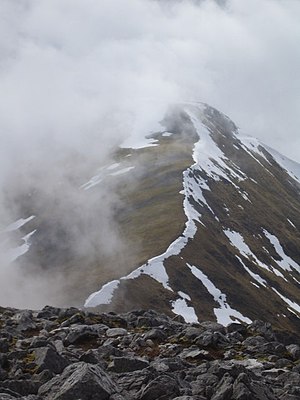
|picture caption=Sgurr a'Choire Ghlais north-east ridge | |picture caption=Sgurr a'Choire Ghlais north-east ridge | ||
|height=3,553 feet | |height=3,553 feet | ||
| | |latitude= 57.444 | ||
|longitude=-4.903 | |||
|os grid ref=NH258430 | |os grid ref=NH258430 | ||
}} | }} | ||
Latest revision as of 19:30, 17 July 2024
| Sgurr a' Choire Ghlais | |
| Ross-shire, Inverness-shire | |
|---|---|
 Sgurr a'Choire Ghlais north-east ridge | |
| Summit: | 3,553 feet NH258430 57°26’38"N, 4°54’11"W |
Sgùrr a' Choire Ghlais is a mountain on the border of Ross-shire with Inverness-shire, which reaches a height of 3,553 feet at its summit, and so it qualifies as a Munro. It stands between Glen Strathfarrar and Glen Orrin
This is the highest mountain in its group, its summit looking out over a broad spectacle, and around it in the same group of mountains are three other Munros; Sgurr na Ruaidhe, Sgurr Fhuar-thuill and Carn nan Gobhar. Northwards there is no higher ground apart from the Fannaichs.
It is one of the most difficult hills to reach in the Highlands, the shortest route involving a 10-mile approach up Glen Strathfarrar. A bicycle, or permission to drive along the private road up Strathfarrar, may shorten the approach.
See also
| ("Wikimedia Commons" has material about Sgùrr a' Choire Ghlais) |
| Munros in SMC Area SMC Section 12 - Glen Cannich to Glen Carron |
|---|
|
An Riabhachan • An Socach • Bidein a' Choire Sheasgaich • Càrn nan Gobhar (Lapaichs) • Càrn nan Gobhar (Strathfarrar) • Lurg Mhòr • Maoile Lunndaidh • Moruisg • Sgùrr a' Chaorachain • Sgùrr a' Choire Ghlais • Sgurr Choinnich • Sgùrr Fhuar-thuill • Sgùrr na Lapaich • Sgùrr na Ruaidhe |
