Difference between revisions of "Moel Lefn"
From Wikishire
(Created page with '{{Infobox hill |name=Moel Lefn |county=Caernarfonshire |range=Moel Hebog |picture=The Northern Crags of Moel Lefn - geograph.org.uk - 234150.jpg |picture caption=The northern fac…') |
|||
| Line 6: | Line 6: | ||
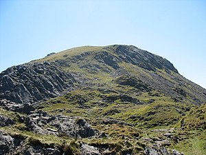
|picture caption=The northern face of Moel Lefn | |picture caption=The northern face of Moel Lefn | ||
|height=2,093 feet | |height=2,093 feet | ||
| − | |os grid ref= | + | |latitude=53.0143946 |
| + | |longitude=-4.158488 | ||
| + | |os grid ref=SH552485 | ||
}} | }} | ||
'''Moel Lefn''' is a 2,093-foot summit rising west of the main [[Snowdonia]] massifs. It is a subsidiary peak of [[Moel Hebog]] and a sister peak of [[Moel yr Ogof]]. Its summit marks the end of the Hebog ridge. | '''Moel Lefn''' is a 2,093-foot summit rising west of the main [[Snowdonia]] massifs. It is a subsidiary peak of [[Moel Hebog]] and a sister peak of [[Moel yr Ogof]]. Its summit marks the end of the Hebog ridge. | ||
| − | The [[Beddgelert]] Forest lies directly to the east, while Cwm Pennant lies to the west. Good views of the Nantlle ridge are obsereved. There are two tall upright stone cairns on the eastern side of the mountain.<ref>Nuttall, John & Anne (1999). The Mountains of England & Wales - Volume 1: Wales (2nd edition ed.). Milnthorpe | + | The [[Beddgelert]] Forest lies directly to the east, while Cwm Pennant lies to the west. Good views of the Nantlle ridge are obsereved. There are two tall upright stone cairns on the eastern side of the mountain.<ref>Nuttall, John & Anne (1999). The Mountains of England & Wales - Volume 1: Wales (2nd edition ed.). Milnthorpe: Cicerone. ISBN 1-85284-304-7.</ref> |
==Outside links== | ==Outside links== | ||
Latest revision as of 17:06, 23 September 2018
| Moel Lefn | |||
| Caernarfonshire | |||
|---|---|---|---|
 The northern face of Moel Lefn | |||
| Range: | Moel Hebog | ||
| Summit: | 2,093 feet SH552485 53°-0’52"N, 4°9’31"W | ||
Moel Lefn is a 2,093-foot summit rising west of the main Snowdonia massifs. It is a subsidiary peak of Moel Hebog and a sister peak of Moel yr Ogof. Its summit marks the end of the Hebog ridge.
The Beddgelert Forest lies directly to the east, while Cwm Pennant lies to the west. Good views of the Nantlle ridge are obsereved. There are two tall upright stone cairns on the eastern side of the mountain.[1]
Outside links
References
- ↑ Nuttall, John & Anne (1999). The Mountains of England & Wales - Volume 1: Wales (2nd edition ed.). Milnthorpe: Cicerone. ISBN 1-85284-304-7.