Warrington: Difference between revisions
No edit summary |
|||
| Line 7: | Line 7: | ||
|latitude=53.382023 | |latitude=53.382023 | ||
|longitude=-2.591950 | |longitude=-2.591950 | ||
|postcode=WA1-5 | |post town=Warrington | ||
|postcode=WA1-5 | |||
|dialling code=01925 | |dialling code=01925 | ||
|LG district=Warrington | |LG district=Warrington | ||
}} | }} | ||
'''Warrington ''' is a town in southern [[Lancashire]]. It stands on the banks of the [[River Mersey]], which is tidal to the west of the weir at Howley. It lies 16 miles east of [[Liverpool]], 19 miles west of Manchester and | '''Warrington ''' is a town in southern [[Lancashire]], with southern suburbs in [[Cheshire]]. It stands on the banks of the [[River Mersey]], which is tidal to the west of the weir at Howley. It lies 16 miles east of [[Liverpool]], 19 miles west of Manchester and eight miles south of [[St Helens]]. The population of the town is 80,661. Its population has more than doubled since its designation as a New Town in 1968. | ||
Warrington was founded by the Romans at an important crossing place on the River Mersey. A new settlement was established by the early English, and by the Middle Ages, Warrington had emerged as a market town at a bridging point of the river. A local tradition of textile and tool production dates from this time. | Warrington was founded by the Romans at an important crossing place on the River Mersey. A new settlement was established by the early English, and by the Middle Ages, Warrington had emerged as a market town at a bridging point of the river. A local tradition of textile and tool production dates from this time. | ||
| Line 17: | Line 18: | ||
The expansion and urbanisation of Warrington largely coincided with the Industrial Revolution, particularly after the Mersey was made navigable in the 18th century, and Warrington joined in the great industrial prosperity of the towns of south Lancashire. | The expansion and urbanisation of Warrington largely coincided with the Industrial Revolution, particularly after the Mersey was made navigable in the 18th century, and Warrington joined in the great industrial prosperity of the towns of south Lancashire. | ||
The West Coast | The [[West Coast Main Line]] runs north to south through the town, and the [[Liverpool]] to [[Manchester]] railway (the Cheshire Lines route) west to east. The [[Manchester Ship Canal]] cuts through the south of the town. The [[M6 motorway|M6]], [[M56 motorway|M56]] and [[M62 motorway]]s form a partial box around the town. | ||
==History== | ==History== | ||
Latest revision as of 13:17, 9 August 2021
| Warrington | |
| Lancashire | |
|---|---|
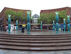 Town Centre | |
| Location | |
| Grid reference: | SJ607874 |
| Location: | 53°22’55"N, 2°35’31"W |
| Data | |
| Post town: | Warrington |
| Postcode: | WA1-5 |
| Dialling code: | 01925 |
| Local Government | |
| Council: | Warrington |
Warrington is a town in southern Lancashire, with southern suburbs in Cheshire. It stands on the banks of the River Mersey, which is tidal to the west of the weir at Howley. It lies 16 miles east of Liverpool, 19 miles west of Manchester and eight miles south of St Helens. The population of the town is 80,661. Its population has more than doubled since its designation as a New Town in 1968.
Warrington was founded by the Romans at an important crossing place on the River Mersey. A new settlement was established by the early English, and by the Middle Ages, Warrington had emerged as a market town at a bridging point of the river. A local tradition of textile and tool production dates from this time.
The expansion and urbanisation of Warrington largely coincided with the Industrial Revolution, particularly after the Mersey was made navigable in the 18th century, and Warrington joined in the great industrial prosperity of the towns of south Lancashire.
The West Coast Main Line runs north to south through the town, and the Liverpool to Manchester railway (the Cheshire Lines route) west to east. The Manchester Ship Canal cuts through the south of the town. The M6, M56 and M62 motorways form a partial box around the town.
History
Warrington has been a major crossing point on the River Mersey since ancient times and there was a Roman settlement at Wilderspool.[1]
In the Middle Ages, Warrington's importance was as a bridging point of the River Mersey.
The town was a fulcrum in the English Civil War. The armies of Oliver Cromwell and the Earl of Derby both stayed near the old town centre (the parish church area). Popular legend has it that Cromwell lodged near the building which survives on Church Street as The Cottage Restaurant. The Marquis of Granby public house bears a plaque stating that the Earl of Derby 'had his quarters near this site'. Dents in the walls of the parish church are rumoured to have been caused by the cannon from the time of the Civil War. On the 13 August 1651 Warrington was the scene of the last Royalist victory of the Civil War when Scots troops under Charles II and David Leslie, Lord Newark, fought Parliamentarians under John Lambert at The Battle of Warrington Bridge.
Industrial history
The expansion and urbanisation of Warrington largely coincided with the Industrial Revolution, particularly after the Mersey was made navigable in the 18th Century. As Britain became industrialised, Warrington embraced the industrial revolution becoming a manufacturing town and a centre of steel (particularly wire), textiles, brewing, tanning and chemical industries. The navigational properties of the river Mersey were improved, canals were built, and the town grew yet more prosperous and popular. When the age of steam came, Warrington naturally welcomed it, both as a means of transport and as a source of power for its mills.
Twentieth century
During Second World War, RAF Burtonwood served as the largest US Army Air Force base outside the United States, and was visited by major celebrities like Humphrey Bogart and Bob Hope who entertained the GIs. It continued in use by the USAAF and subsequently USAF as a staging post for men and matériel until 1993.
There was a further RAF training camp at Padgate, a Royal Naval air base at Appleton Thorn (RNAS Stretton) and an army base at the Peninsula Barracks in O'Leary Street, now used by the Territorial Army.
Warrington, and ancient town, was made a "new town" in 1968 and built up rapidly as a result.
Heavy industry declined in the 1970s and 1980s but the growth of the new town around Warrington led to a great increase in employment in light industry, distribution and technology.
In October 1987, Swedish home products retailer IKEA opened its first British store in the Great Sankey area of the town, bringing more than 200 retail jobs to the area.[2]
IRA bombing
On 20 March 1993, the IRA detonated two bombs in Warrington town centre. The blasts killed two children: three-year-old Jonathan Ball died instantly, and twelve-year-old Tim Parry died five days later in hospital. Around 56 other people were injured, four seriously. Their deaths provoked widespread condemnation of the organisation responsible. The blast followed a bomb attack a few weeks earlier on a gas-storage plant in Warrington.
Tim Parry's father Colin Parry founded The Peace Centre as part of a campaign to reconcile communities in conflict. The centre opened on the seventh anniversary of the bombing in 2000. He and his family still live in the town.
Transport
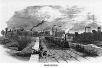
The town has two main railway stations: Bank Quay is on the main West Coast Main Line between London Euston and Glasgow Central and the Manchester Piccadilly to North Wales by way of Chester line, while Warrington Central is on the Liverpool to Manchester (by way of Widnes and Warrington) line with through services to the North East and to East Anglia. Bank Quay is much altered, but Central (built 1873) is of some architectural merit, featuring polychromatic brickwork. Both have undergone some refurbishment. There are also railway stations in the suburbs at Padgate, Sankey,Glazebrook and Birchwood.
The town lies close to the M62, M6 and M56 motorways and midway between Liverpool and Manchester airports. It also has four Primary A roads A49, A50, A56 and A57. The A580 (East Lancs) runs along the north of the town.
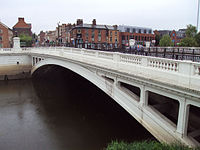
The River Mersey runs through the heart of the town dividing it in two and thus dividing the town between Lancashire to the north and Cheshire to the south. There are only two main thoroughfares crossing the Mersey in Warrington: at Bridge Foot and at the Kingsway Bridge. Before the M6 was built, these routes were very busy with through traffic.
The Manchester Ship Canal runs through the south of the town; three swing bridges and a high-level cantilever bridge provide crossing points, and another high-level crossing is planned downstream nearer to Runcorn. Although shipping movements on the ship canal are far less frequent than in years past, they can cause severe delay to local road traffic. The picturesque Bridgewater Canal runs through the borough from the scenic village of Lymm to Walton Hall and Gardens, a local park/leisure area.
Culture and leisure
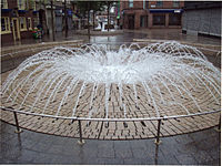
Warrington has a concert hall (the Parr Hall), an arts centre (the Pyramid), a museum (Warrington Museum & Art Gallery), and various public libraries throughout the borough. Warrington Central Library was the first rate-supported library in the United Kingdom.
The Victorian swimming baths closed in July 2003. There is a cinema at Westbrook, and another is being considered as part of a town centre redevelopment. There are several parks (see also Parks in Warrington) and designated nature reserves at Woolston Eyes, Risley Moss, Rixton Claypits, and Paddington Meadows.
A ten-pin bowling is found at Winwick Quay, and indoor paintball. An indoor karting centre is located near to Bank Quay. Alongside the karting centre is a golf driving range, with an American golf shop attached. Pitch and putt and crazy golf are available at Walton Hall and Gardens. A Laser Quest arena and a snooker club can also be found in Warrington, both located close to the town centre. Gulliver's World Theme Park is located in Old Hall, Apple Jacks Farm Theme Park is situated in Stretton.
Festivals
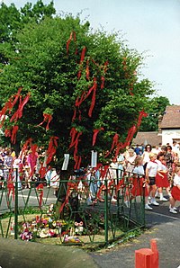
A number of festivals, carnivals, and walking days are held each year in and around Warrington.
- Warrington Walking Day - originally a Sunday School festival - is held on the closest Friday to the last day of June, and the town centre is closed to traffic as churches walk together through the streets.[3]
Other festivals, besides the many walking days, include:
- Appleton Thorn Bawming of the Thorn
- Birchwood Carnival and Safari Day
- Croft Carnival
- Culcheth Community Day
- Glazebury Gala
- Grappenhall Welly Wanging Competition
- Howley Carnival
- Lymm May Queen
- Lymm Dickensian Festival
- Penketh Carnival
- St George's Day Parade
- Thelwall Rose Queen
- Matt Humo WireFest
- Risley Safari Day in Risley Moss Birchwood
- Winwick Carnival
- Westy Carnival
Warrington also has many musical groups, including Warrington Male Voice Choir, Warrington Youth Orchestra, North Cheshire Wind Orchestra, Centenary Theatre Company[4] and the Bridgewater Players Drama Group.
Sights about the town
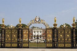
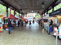
Sites of interest in Warrington include:
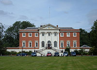
- The Town Hall (and its golden gates), formerly Bank Hall (built 1750), the home of the Philips family and their scion the artist Nathaniel George Philips.[5]
- The Warrington Academy, a dissenters' institute where Joseph Priestley once taught. After being moved from their original location, the building now houses the offices of the local newspaper "The Warrington Guardian". A statue of Oliver Cromwell stands in front.
- "Cromwell's Cottage" (17th century), which Cromwell is said to have visited.
- The 14th century Parish Church of St Elphin, largely a Victorian rebuilding of the original with a 281-foot spire, the sixth tallest in the United Kingdom.
- St Wilfrid's Church, Grappenhall, Grade I listed mediæval church
- St Oswald's Church, Winwick, Grade I listed mediæval church
- Holy Trinity Church, 1758, Grade II* listed Georgian church at Market Gate.
- Old St Ann's Church, 1869, Grade II* church designed by John Douglas, now a rock climbing centre.
- St Mary's Church, Grade II church designed by E W Pugin and Peter Paul Pugin in Buttermarket.
- Warrington Museum & Art Gallery, Grade II listed building and one of the oldest municipal museums in the United Kingdom
- The row of late Victorian terracotta shops on Bridge Street.[6]
- The Art Deco style Halo nightclub (formerly the ABC cinema and before this The Ritz), although the nightclub has now closed.
- The industrial modernist Unilever Soapworks.
- The Cheshire Lines railway warehouse, now redeveloped as apartments.
- The Warrington Transporter Bridge, a listed building and a Scheduled Ancient Monument.[7]
- The Barley Mow, established in 1561, the oldest pub in Warrington.
- The Parr Hall, home to one of the few remaining Cavaillé-Coll organs.
- Fiddlers Ferry Power Station
- The Halliwell Jones Stadium home of Warrington Wolves
- Bewsey Old Hall, a rebuilt mediæval manor house.
References
- ↑ .Hinchcliffe J & Williams J H, ROMAN WARRINGTON: Excavations at Wilderspool 1966 - 9 & 1976,Brigantia Monograph No 2, Manchester University 1992
- ↑ [1]
- ↑ Forrest David, Warrington Walking Day: A Brief History
- ↑ Centenary Theatre website
- ↑ "Town Hall Guide". Warrington Borough Council. 2007. Archived from the original on 2007-07-12. http://web.archive.org/web/20070712025833/http://www.warrington.gov.uk/Leisureandculture/Localhistoryandheritage/Town_Hall_Guide.aspx. Retrieved 2007-05-23.
- ↑ "Bridge Street Conservation Area". Warrington Borough Council. 2000. Archived from the original on 2007-07-03. http://web.archive.org/web/20070703184854/http://www.warrington.gov.uk/Images/6_Bridge_St_tcm31-3124.pdf. Retrieved 2007-05-23.
- ↑ English Heritage