Template:Infobox town: Difference between revisions
Jump to navigation
Jump to search
Yorkshire ridings tag |
No edit summary |
||
| Line 29: | Line 29: | ||
{{#if: {{{latitude<includeonly>|</includeonly>}}} | | {{#if: {{{latitude<includeonly>|</includeonly>}}} | | ||
! style="background: #D0F0C0;" {{!}} Location: | ! style="background: #D0F0C0;" {{!}} Location: | ||
{{!}} {{lat & long|{{{latitude}}}|{{{longitude}}} }} }} | {{!}} [http://wikishire.co.uk/map/#{{{latitude}}},{{{longitude}}} {{lat & long|{{{latitude}}}|{{{longitude}}} }}] }} | ||
|- | |- | ||
| colspan="2" style="background: #D0F0C0; text-align: center;"|'''Data''' | | colspan="2" style="background: #D0F0C0; text-align: center;"|'''Data''' | ||
Revision as of 11:30, 1 April 2014
| Infobox town | |
| [[]] | |
|---|---|
| [[File:{{{picture}}}|240px]] {{{picture caption}}} | |
| Location | |
| Island: | [[{{{island}}}]] |
| Grid reference: | Expression error: Unexpected < operator.&y=Expression error: Unexpected < operator.&z=120 {{{os grid ref}}} |
| Location: | {{{latitude}}} {{{longitude}}} |
| Data | |
| Population: | {{{population}}} |
| Post town: | {{{post town}}} |
| Postcode: | {{{postcode}}} |
| Dialling code: | {{{dialling code}}} |
| Local Government | |
| Council: | {{{LG district}}} |
| Parliamentary constituency: |
{{{constituency}}} |
| Website: | {{{website}}} |
Usage
Fields (blank template)
{{Infobox town
| name=
| welsh=
| gaelic=
| irish=
| scots=
| cornish=
| jerriais=
| dgernesiais=
| manx=
| county=
| riding=
| island=
| picture=
| picture caption=
| latitude=
| longitude=
| os grid ref=
| population=
| census year=
| post town=
| postcode=
| dialling code=
| LG district=
| constituency=
| website=
}}
Completing the fields
All of the fields above are optional apart from "county=" (which may be given as "territory=" or "bailiwick=" as appropriate. For general guidance see Guide to town and village articles. For specific key fields:
Name, county etc:
- name - The name of the town as it will appear at the head of the box. It can be left out if the article has the same name but it is usually filled in.
- cornish, gaelic, jerriais, welsh etc - the name in the appropriate language, if it is appropriate to the particular village to have another language's version, for example for a Gaelic-speaking village (or one which was Gaelic speaking in recent history).
- county - The county in which the town lies. If it is on the boundary, the county it is mainly within. Alternatively the fields county 1 and county 2 can be employed where appropriate. For an overseas territory or crown dependency, the field territory or bailiwick may be used instead. They are functionally interchangeable.
- island - Do not use this field if the island on which the town is found is Great Britain or Ireland nor if it is Anglesey or the Isle of Man as the "county" field deals with that.
Picture
- picture - The file name of a picture on Commons, without the "File:" element.
Location fields
For these fields we recommend finding the place on Streetmap as it has a tag at the bottom "Click here to convert coordinates." which will give you the grid reference, latitude and longitude and nearest postcode all in the right form for use in the Infobox:
- os grid ref - do not put spaces in the grid ref. It will create a link directly to Ordnance Survey
- latitiude and longitude - use a decimal number (as Streetmap provide). The programme will convert it to degrees, minutes and seconds.
- postcode - just the first half of a postcode should do.
Townland
A town or village in Ulster or the Republic of Ireland might also be a townland or share its name with a townland. For these, there is the optional "townland" field:
|townland=yes
- will categorise the place also in "Townlands of [county]".
Examples
Example 1: Abingdon
| Abingdon | |
| Berkshire | |
|---|---|
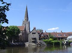
 The River Thames at Abingdon looking towards St. Helen's parish church | |
| Location | |
| Location: | 51.667 N, -1.283 W |
| Grid reference: | SU4997 |
| Data | |
| Population: | 36,626 |
| Post town: | Abingdon |
| Postcode: | OX14 |
| Dialling code: | 01235 |
| Local Government | |
| Council: | Vale of White Horse |
| Parliamentary constituency: |
Oxford West and Abingdon |
| Website: | Abingdon Town Council |
Example 2: Youghal
| Youghal Irish: Eochaill | |
| County Cork | |
|---|---|
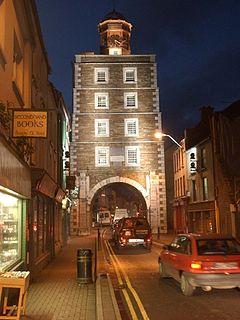
 The Clock Gate | |
| Location | |
| Location: | 51.951671 N, -7.845612 W |
| Grid reference: | X102781 |
| Data | |
| Population: | 6393 |
| Local Government | |
| Website: | www.youghal.ie |