Erganagh: Difference between revisions
Jump to navigation
Jump to search
Created page with '{{Infobox town |name=Erganagh |county=Tyrone |picture= |picture caption= |os grid ref=H2985 |LG district=Strabane }} '''Erganagh''' is a village in Tyrone. {{stub}}' |
No edit summary |
||
| Line 2: | Line 2: | ||
|name=Erganagh | |name=Erganagh | ||
|county=Tyrone | |county=Tyrone | ||
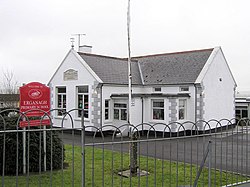
|picture= | |picture=Erganagh Primary School - geograph.org.uk - 137373.jpg | ||
|picture caption= | |picture caption=Erganagh Primary School | ||
|os grid ref= | |os grid ref=H290849 | ||
|LG district=Strabane | |latitude=54.7113 | ||
|longitude=-7.550735 | |||
|population= | |||
|census year= | |||
|post town= | |||
|postcode= | |||
|dialling code=028 | |||
|townland= | |||
|LG district=Derry and Strabane | |||
|constituency= | |||
}} | }} | ||
'''Erganagh''' is a village in [[Tyrone]]. | '''Erganagh''' is a small village and townland (of 498 acres) near [[Castlederg]] in [[Tyrone]], in the Barony of [[Strabane Lower]]. The 2001 Census recorded a population of 366 people. | ||
{{ | {{commons}} | ||
==References== | |||
{{reflist}} | |||
[[File:Cottage at Erganagh Glebe - geograph.org.uk - 585719.jpg|left|thumb|200px|Cottage at Erganagh Glebe]] | |||
Latest revision as of 21:51, 1 December 2022
| Erganagh | |
| Tyrone | |
|---|---|
 Erganagh Primary School | |
| Location | |
| Grid reference: | H290849 |
| Location: | 54°42’41"N, 7°33’3"W |
| Data | |
| Dialling code: | 028 |
| Local Government | |
| Council: | Derry and Strabane |
Erganagh is a small village and townland (of 498 acres) near Castlederg in Tyrone, in the Barony of Strabane Lower. The 2001 Census recorded a population of 366 people.
| ("Wikimedia Commons" has material about Erganagh) |
References

