Mount Sugartop: Difference between revisions
Jump to navigation
Jump to search
Created page with '{{Infobox hill |name=Mount Sugartop |territory=South Georgia and the South Sandwich Islands |island=South Georgia |picture=Sugartop.jpg |picture caption=Mount Sugartop |height={{…' |
No edit summary |
||
| Line 11: | Line 11: | ||
The name "Sugarloaf Peak" has appeared on maps for this feature for many years, but the South Georgia Survey, following its 1951-52 surveying expedition, reported that the name Mount Sugartop is well established locally for this mountain. This latter name is approved on the basis of local usage. | The name "Sugarloaf Peak" has appeared on maps for this feature for many years, but the South Georgia Survey, following its 1951-52 surveying expedition, reported that the name Mount Sugartop is well established locally for this mountain. This latter name is approved on the basis of local usage. | ||
==References== | |||
*{{basgaz}} | *{{basgaz}} | ||
Revision as of 23:29, 28 February 2018
| Mount Sugartop | |||
| South Georgia and the South Sandwich Islands | |||
|---|---|---|---|
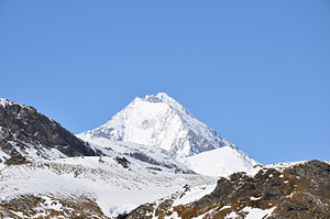
 Mount Sugartop | |||
| South Georgia | |||
| Summit: | 7,628 feet | ||
Mount Sugartop (54°22′S 36°38′W / 54.367°S 36.633°WCoordinates: 54°22′S 36°38′W / 54.367°S 36.633°W) is a prominent, partly snow-covered mountain of 7,628 feet standing 5 miles northwest of Mount Paget in the Allardyce Range of South Georgia.
The name "Sugarloaf Peak" has appeared on maps for this feature for many years, but the South Georgia Survey, following its 1951-52 surveying expedition, reported that the name Mount Sugartop is well established locally for this mountain. This latter name is approved on the basis of local usage.
References
- Gazetteer and Map of South Georgia and the South Sandwich Islands: Mount Sugartop