Kexbrough: Difference between revisions
Jump to navigation
Jump to search
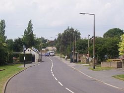
Created page with "{{Infobox town |name=Kexbrough |county=Yorkshire |riding=West |picture=Kexborough Village.jpg |picture caption=Churchfield Lane in Kexbrough |os grid ref=SE305095 |latitude=53..." |
|||
| Line 18: | Line 18: | ||
==History== | ==History== | ||
Kexbrough is recorded in the [[Domesday Book]] as belonging to Ilbert of Lacey, and having two villagers, a meadow, ploughlands and six furlongs of woodland.<ref>{{OpenDomesday|SE2909|Kexbrough}}</ref> Historically in the parish of Darton and the wapentake of [[Staincross]], the village is recorded in the Domesday Book as ''Chizeburg''. It appears as ''Kesseburgh'' in the 14th century, and ''Kexbrough'' by the 1580s. The name is derived from a combination of a personal name, and ''burh'', which meant a fortified place.<ref>{{placenames}}</ref><ref>{{cite book |last1=Moorman |first1=F. W. |title=Place-Names of the West Riding of Yorkshire |date=1910 |publisher=Thoresby Society |location=Leeds |page=113|oclc=4288848}}</ref><ref>{{Ekwall|pp=74, 274}}</ref> | Kexbrough is recorded in the [[Domesday Book]] as belonging to Ilbert of Lacey, and having two villagers, a meadow, ploughlands and six furlongs of woodland.<ref>{{OpenDomesday|SE2909|Kexbrough}}</ref> Historically in the parish of Darton and the wapentake of [[Staincross Wapentake|Staincross]], the village is recorded in the Domesday Book as ''Chizeburg''. It appears as ''Kesseburgh'' in the 14th century, and ''Kexbrough'' by the 1580s. The name is derived from a combination of a personal name, and ''burh'', which meant a fortified place.<ref>{{placenames}}</ref><ref>{{cite book |last1=Moorman |first1=F. W. |title=Place-Names of the West Riding of Yorkshire |date=1910 |publisher=Thoresby Society |location=Leeds |page=113|oclc=4288848}}</ref><ref>{{Ekwall|pp=74, 274}}</ref> | ||
{{commons|Kexbrough}} | {{commons|Kexbrough}} | ||
==References== | ==References== | ||
{{reflist}} | {{reflist}} | ||
Latest revision as of 20:42, 6 November 2023
| Kexbrough | |
| Yorkshire West Riding | |
|---|---|
 Churchfield Lane in Kexbrough | |
| Location | |
| Grid reference: | SE305095 |
| Location: | 53°34’54"N, 1°32’22"W |
| Data | |
| Post town: | Barnsley |
| Postcode: | S75 |
| Dialling code: | 01226 |
| Local Government | |
| Council: | Barnsley |
| Parliamentary constituency: |
Barnsley West and Penistone |
Kexbrough is a village in the West Riding of Yorkshire, sitting just west of the M1 motorway, south of Junction 38. Historically the village was known as ‘Kexborough’. The parish includes such hamlets of Haigh and Swithin.[1]
History
Kexbrough is recorded in the Domesday Book as belonging to Ilbert of Lacey, and having two villagers, a meadow, ploughlands and six furlongs of woodland.[2] Historically in the parish of Darton and the wapentake of Staincross, the village is recorded in the Domesday Book as Chizeburg. It appears as Kesseburgh in the 14th century, and Kexbrough by the 1580s. The name is derived from a combination of a personal name, and burh, which meant a fortified place.[3][4][5]
| ("Wikimedia Commons" has material about Kexbrough) |
References
- ↑ "Kexborough West Riding". https://visionofireland.org/place/13178#.
- ↑ Kexbrough in the Domesday Book
- ↑ Smith, A.H.: 'Place-Names of West Riding of Yorkshire , Part' (English Place-Names Society, 1961-3)
- ↑ Moorman, F. W. (1910). Place-Names of the West Riding of Yorkshire. Leeds: Thoresby Society. p. 113. OCLC 4288848.
- ↑ Ekwall, Eilert, The Concise Oxford Dictionary of English Place-Names. Oxford, Oxford University Press, 4th edition, 1960. ISBN 0198691033
