Liège Island: Difference between revisions
Jump to navigation
Jump to search
Redirected page to Liege Island |
No edit summary |
||
| (2 intermediate revisions by the same user not shown) | |||
| Line 1: | Line 1: | ||
{{Infobox island | |||
|name=Liège Island | |||
|territory=British Antarctic Territory | |||
|group=Palmer Archipelago | |||
|map=Liège Island, Palmer Archipelago, BAT.svg | |||
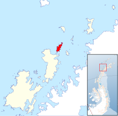
|map caption=Location of Liege Island | |||
|latitude=-64.019444 | |||
|longitude=-61.933333 | |||
}} | |||
'''Liège Island''' is an island, 9 nautical miles long and 3 nautical miles wide, in the [[Palmer Archipelago]], off [[Graham Land]] in the [[British Antarctic Territory]]. It lies immediately northeast of [[Brabant Island]] and is separated from [[Hoseason Island]] and [[Christiania Islands]] to the northeast by [[Croker Passage]]. Its interior is occupied by [[Brugmann Mountains]]. | |||
The island was charted by the Belgian Antarctic Expedition (1897–1899) under Adrien de Gerlache, who named it for the Province of Liège in Belgium. | |||
==Maps== | |||
*[http://data.aad.gov.au/aadc/mapcat/display_map.cfm?map_id=3198 British Antarctic Territory.] Scale 1:200000 topographic map. DOS 610 Series, Sheet W 64 60. Directorate of Overseas Surveys, UK, 1978. | |||
*[http://data.aad.gov.au/aadc/mapcat/display_map.cfm?map_id=3217 British Antarctic Territory.] Scale 1:200000 topographic map. DOS 610 Series, Sheet W 64 62. Directorate of Overseas Surveys, UK, 1980. | |||
*[http://www.add.scar.org/home Antarctic Digital Database (ADD).] Scale 1:250000 topographic map of Antarctica. Scientific Committee on Antarctic Research (SCAR), 1993-2012. | |||
==Outside links== | |||
*{{basgaz}} | |||
==References== | |||
{{reflist}} | |||
{{Palmer Archipelago}} | |||
Latest revision as of 08:46, 8 December 2022
| Liège Island | |
| Location | |
| Location: | 64°1’10"S, 61°55’60"W |
| Data | |
Liège Island is an island, 9 nautical miles long and 3 nautical miles wide, in the Palmer Archipelago, off Graham Land in the British Antarctic Territory. It lies immediately northeast of Brabant Island and is separated from Hoseason Island and Christiania Islands to the northeast by Croker Passage. Its interior is occupied by Brugmann Mountains.
The island was charted by the Belgian Antarctic Expedition (1897–1899) under Adrien de Gerlache, who named it for the Province of Liège in Belgium.
Maps
- British Antarctic Territory. Scale 1:200000 topographic map. DOS 610 Series, Sheet W 64 60. Directorate of Overseas Surveys, UK, 1978.
- British Antarctic Territory. Scale 1:200000 topographic map. DOS 610 Series, Sheet W 64 62. Directorate of Overseas Surveys, UK, 1980.
- Antarctic Digital Database (ADD). Scale 1:250000 topographic map of Antarctica. Scientific Committee on Antarctic Research (SCAR), 1993-2012.
Outside links
- Gazetteer and Map of The British Antarctic Territory: Liège Island
