Shag Rocks: Difference between revisions
No edit summary |
|||
| Line 37: | Line 37: | ||
{{SGSSI}} | {{SGSSI}} | ||
[Category:Extreme points of South Georgia and the South Sandwich Islands]] | [[Category:Extreme points of South Georgia and the South Sandwich Islands]] | ||
Latest revision as of 15:26, 18 March 2018
| Shag Rocks | |
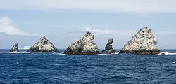
 The Shag Rocks | |
|---|---|
| Location | |
| Location: | 53°33’-0"S, 42°1’60"W |
| Area: | 49 acres |
| Highest point: | 246 feet |
| Data | |
| Population: | 0 |
The Shag Rocks are six small islands standing to the west of South Georgia and forming the westernmost extreme of the territory of South Georgia and the South Sandwich Islands, 150 miles west of South Georgia itself and 620 miles east of the Falkland Islands. Ten miles further southeast is Black Rock.
Black Rock and Shag Rocks are on the route from the Falkland Islands to South Georgia, on a seamount of Scotia Ridge.
The Shag Rocks are uninhabited and so lack any active administration. Before 1985 they came within the Falkland Islands Dependencies. In 1985, following the 1982 Falklands War, the Falkland Islands Dependencies were reorganised and Black Rock was assigned to the new colony of South Georgia and the South Sandwich Islands, which includes Shag Rocks also.
Character and wildlife
The Shag Rocks cover a total area of less than 49 acres. Standing on the South Georgia Ridge, they have a peak elevation above sea level of 246 feet, and stand in water approximately 1,047 feet deep. There is no significant vegetation.
The main wildlife found on the islands are the South Georgian (Imperial) shags, prions and wandering albatrosses.
Name
Though José de la Llana claimed to have discovered islets in the area in 1762, which he named the Aurora Islands, after his ship, the Aurora Islands are considered by many to have been a mistaken sighting that was coincidentally near the Shag Rocks. The Shag Rocks were known to sealers before 1823 but formally discovered and charted by James Sheffield and given their current name, probably because shags and other seabirds frequent them. The rocks were charted by Discovery Investigations personnel on the William Scoresby in 1927. The first recorded landing on the islands was made in 1956, when an Argentine geologist was lowered from a helicopter to collect rock samples.
Outside links
References
- Gazetteer and Map of South Georgia and the South Sandwich Islands: Shag Rocks
| South Georgia and the South Sandwich Islands | |
|---|---|
| South Georgia: | Annenkov Island • Bird Island • Clerke Rocks • Cooper Island • Grass Island • Kupriyanov Islands • Pickersgill Islands • Saddle Island • Shag Rocks • South Georgia • Welcome Islands • Willis Islands • Trinity Island • Grassholm • Black Rocks • Black Rock |
| South Sandwich Islands: |
Bellingshausen • Bristol • Candlemas • Cook • Leskov • Montagu • Saunders • Thule • Vindication • Visokoi • Zavodovski |