Widford, Oxfordshire: Difference between revisions
Created page with "{{infobox town |name= Widford |county 1=Oxfordshire |county 2=Gloucestershire |picture= Widford StOswald SE.JPG |picture caption= St Oswald's parish church |latitude= 51.805 |..." |
m Owain moved page Widford, Gloucestershire to Widford, Oxfordshire |
(No difference)
| |
Latest revision as of 16:38, 25 February 2016
| Widford | |
| Oxfordshire, Gloucestershire | |
|---|---|
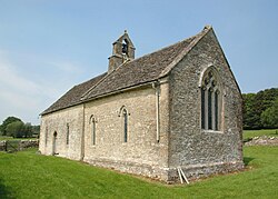
 St Oswald's parish church | |
| Location | |
| Location: | 51°48’18"N, 1°36’14"W |
| Data | |
| Post town: | Burford |
| Postcode: | OX18 |
| Dialling code: | 01993 |
| Local Government | |
| Council: | West Oxfordshire |
| Parliamentary constituency: |
Witney |
Widford is a hamlet, ancient parish and deserted mediæval village forming a detached part of Gloucestershire, locally situate in Oxfordshire. The hamlet sits on the River Windrush about a mile and half east of Burford.
History
Early occupation is evidenced by the remains of a Roman villa. The Church of England parish church of St Oswald stands on its site, and a small area of Roman mosaic was visible in its chancel,[1] but has been moved to Cirencester museum.
The Domesday book records that by 1086 St Oswald's Priory in Gloucester held the manor of Widford.[2] St Oswald's church in Widford is Early English Gothic and was built in the 13th century.[1] In the 14th century numerous wall paintings were added, remains of which survive.[1] Most of the church's present windows were added in the 16th and 17th centuries.[1]
Widford was a substantial village in the Middle Ages but today only the 16th-century manor house and a few other houses remain. St Oswald's stands in a field whose cropmarks show the outlines of former buildings.
Widford was a civil parish from 1866, but by 1931 its population was only 29.[3] In 1932 the civil parish was merged with the parish of Swinbrook to form the civil parish of Swinbrook and Widford.
References
| ("Wikimedia Commons" has material about Oxfordshire Widford, Oxfordshire) |
- ↑ 1.0 1.1 1.2 1.3 Sherwood & Pevsner 1974, p. 841.
- ↑ Crossley & Currie 1996, pp. 1–5.
- ↑ Vision of Britain: Widford CP, population table
Sources and further reading
- Crossley, Alan; Currie, C.R.J. (eds.); Baggs, A.P.; Chance, Eleanor; Colvin, Christina; Day, C.J.; Selwyn, Nesta; Townley, Simon C. (1996). A History of the County of Oxford, Volume 13: Bampton Hundred (Part One). Victoria County History. pp. 1–5. http://www.british-history.ac.uk/report.aspx?compid=15911.
- Edwards, John (1982). "A Newly-Deciphered Wall-painting of St. Martin at Widford.". Oxoniensia (Oxfordshire Architectural and Historical Society) XLVII: 127–132.
- Edwards, John (1984). "Widford Wall-paintings: More New Decipherments". Oxoniensia (Oxfordshire Architectural and Historical Society) XLIX: 133–139.
- Sherwood, Jennifer; Nikolaus, Pevsner (1974). Oxfordshire. The Buildings of England. Harmondsworth: Penguin Books. p. 841. ISBN 0-14-071045-0.
