Forty Green, Bledlow: Difference between revisions
Jump to navigation
Jump to search
Created page with "{{Infobox town |name=Forty Green |county=Buckinghamshire |picture=Maize and wheat fields near Forty Green - geograph.org.uk - 32907.jpg |picture caption=Fields near Forty Gree..." |
No edit summary |
||
| (One intermediate revision by the same user not shown) | |||
| Line 15: | Line 15: | ||
|constituency= | |constituency= | ||
}} | }} | ||
'''Forty Green''' is a tiny hamlet in the very west of [[Buckinghamshire]], sitting on a dead-end land north out of [[Bledlow]] village. The Cuttle Brook runs a hundred yards of so west of the hamlet, marking the border with [[Oxfordshire]], across which is [[Henton]]: the two sides are bridged and linked only with two small footbridges and footpaths. | '''Forty Green''' is a tiny hamlet in the very west of [[Buckinghamshire]], sitting on a dead-end land north out of [[Bledlow]] village. The Cuttle Brook runs a hundred yards of so west of the hamlet, marking the border with [[Oxfordshire]], across which is [[Henton, Oxfordshire|Henton]]: the two sides are bridged and linked only with two small footbridges and footpaths. | ||
North of Forty Green, just as the lane fizzles out and becomes a footpath, a cycling route crosses the boundary and the top of the lane, on a path using the route of the old railway line which once linked [[Thame]] with [[Princes Risborough]]. | North of Forty Green, just as the lane fizzles out and becomes a footpath, a cycling route crosses the boundary and the top of the lane, on a path using the route of the old railway line which once linked [[Thame]] with [[Princes Risborough]]. | ||
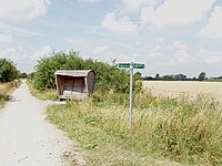
[[File:Sustrans shelter on Thame to Princes Risborough cycle track - geograph.org.uk - 32911.jpg|right|thumb|200px|The | [[File:Sustrans shelter on Thame to Princes Risborough cycle track - geograph.org.uk - 32911.jpg|right|thumb|200px|The Thame to Princes Risborough Cycling Route at Forty Green]] | ||
==Outside links== | ==Outside links== | ||
{{commons}} | {{commons}} | ||
Latest revision as of 23:20, 20 February 2024
| Forty Green | |
| Buckinghamshire | |
|---|---|
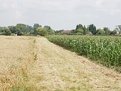
 Fields near Forty Green | |
| Location | |
| Grid reference: | SP769037 |
| Location: | 51°43’36"N, -0°53’17"W |
| Data | |
| Post town: | HP27 |
| Local Government | |
Forty Green is a tiny hamlet in the very west of Buckinghamshire, sitting on a dead-end land north out of Bledlow village. The Cuttle Brook runs a hundred yards of so west of the hamlet, marking the border with Oxfordshire, across which is Henton: the two sides are bridged and linked only with two small footbridges and footpaths.
North of Forty Green, just as the lane fizzles out and becomes a footpath, a cycling route crosses the boundary and the top of the lane, on a path using the route of the old railway line which once linked Thame with Princes Risborough.

Outside links
| ("Wikimedia Commons" has material about Forty Green, Bledlow) |
