Stoneyburn: Difference between revisions
Created page with "{{Infobox town |county=West Lothian |name=Stoneyburn |picture= |picture caption= |os grid ref=NS978628 |latitude=55.848 |longitude=-3.631 |population=3,790 |census year=2004 e..." |
mNo edit summary |
||
| Line 2: | Line 2: | ||
|county=West Lothian | |county=West Lothian | ||
|name=Stoneyburn | |name=Stoneyburn | ||
|picture= | |picture=Foulshiels Park in Stoneyburn, West Lothian - geograph-4489943.jpg | ||
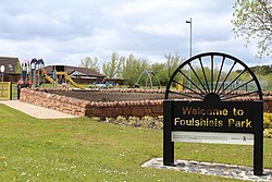
|picture caption= | |picture caption=Foulshiels Park in Stoneyburn | ||
|os grid ref=NS978628 | |os grid ref=NS978628 | ||
|latitude=55.848 | |latitude=55.848 | ||
| Line 22: | Line 22: | ||
==Location== | ==Location== | ||
This is a village sitting in the heart of the [[ | This is a village sitting in the heart of the Central [[Lowlands]] in the corridor between the two great cities of [[Edinburgh]] and [[Glasgow]], approximately 25 miles from the centre of each of them. Stoneyburn is two miles away from junction 4 of the [[M8 motorway]] between the cities. | ||
It is to be found some four miles from Bathgate to the north and five miles from [[Livingston]] to the east. | It is to be found some four miles from Bathgate to the north and five miles from [[Livingston]] to the east. | ||
Latest revision as of 20:16, 30 July 2015
| Stoneyburn | |
| West Lothian | |
|---|---|
 Foulshiels Park in Stoneyburn | |
| Location | |
| Grid reference: | NS978628 |
| Location: | 55°50’53"N, 3°37’52"W |
| Data | |
| Population: | 3,790 (2004 est) |
| Post town: | Bathgate |
| Postcode: | EH47 |
| Dialling code: | 01501 |
| Local Government | |
| Council: | West Lothian |
| Parliamentary constituency: |
Livingston |
Stoneyburn is a village in West Lothian. Nearby towns include Bathgate, Whitburn, Addiewell and Blackburn.
Traditionally, the village is divided between Stoneyburn proper and Bents, and in the days before the Beeching Axe, the village's railway station was at Bents.
Notwithstanding the placing of Stoneyburn in the busy corridor between two of the greatest cities of the United Kingdom, it contrives to remain a semi-rural area, surrounded by dairy farms and fields. Around three thousand people inhabit the village, which is around a mile and a half in length, clustered around the B7015 to Fauldhouse and Livingston.
Location
This is a village sitting in the heart of the Central Lowlands in the corridor between the two great cities of Edinburgh and Glasgow, approximately 25 miles from the centre of each of them. Stoneyburn is two miles away from junction 4 of the M8 motorway between the cities.
It is to be found some four miles from Bathgate to the north and five miles from Livingston to the east.
Churches
- Church of Scotland: Stoneyburn Parish Church
- Pentecostal
- Roman Catholic: Our Lady
Community
The village has two primary schools, one state and one Roman Catholic. It has a Masonic Lodge too. The village also has local shops including a café, florists, post office, chemist and convenience shops. There is also a Community Centre and a Health Centre within the village.
A Loyalist Flute Band called the Stoneyburn Crown Defenders is based and plays in the village.
The public houses in the village are the Ewington Hotel and The Bentswood Inn.
Sport
- Bowls: village bowling club
- Football (junior): Stoneyburn FC
Outside links
| ("Wikimedia Commons" has material about Stoneyburn) |
