Mousa Broch: Difference between revisions
mNo edit summary |
No edit summary |
||
| (One intermediate revision by one other user not shown) | |||
| Line 1: | Line 1: | ||
{{county|Shetland}} | |||
[[File:Mousa Broch - geograph.org.uk - 335305.jpg|right|thumb|350px|Mousa Broch]] | [[File:Mousa Broch - geograph.org.uk - 335305.jpg|right|thumb|350px|Mousa Broch]] | ||
[[File:Mousa Broch 20080821 03.jpg|right|thumb|250px|Mousa Broch interior]] | [[File:Mousa Broch 20080821 03.jpg|right|thumb|250px|Mousa Broch interior]] | ||
| Line 45: | Line 46: | ||
}} | }} | ||
{{ | ==Outside links== | ||
*Location map: {{wmap|59.99562|-1.18259|zoom=14}} | |||
{{Prehistoric Shetland}} | {{Prehistoric Shetland}} | ||
[[Category:Brochs of Shetland]] | [[Category:Brochs of Shetland]] | ||
[[Category:Historic Scotland sites in Shetland]] | |||
Latest revision as of 17:58, 2 March 2019


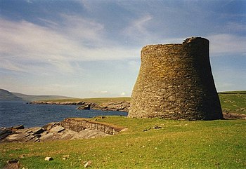
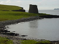
Mousa Broch stands on the island of Mousa in Shetland, and is the finest preserved example of a broch or round tower in the British Isles. It is the tallest still standing in the world[1] and amongst the best-preserved prehistoric buildings in Britain or indeed in Europe.[2]
The broch is an Iron Age fortress, thought to have been built around 100 BC, one of 570 brochs built throughout the northern coastlands.[3] The site is managed by Historic Scotland.
Description
Mousa Broch has one of the smallest overall diameters of any broch, as well as one of the thickest wall bases and smallest interiors; this massive construction and its remote location are likely to be the main explanation for its excellent state of preservation.
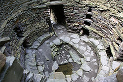
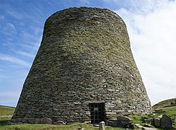
Standing on the island of Mousa at HU457237, the broch stands 44 feet high and its interior is accessible by a single entrance at ground level. Once inside, a visitor may ascend an internal staircase to an open walkway at the top. It is the only broch which is complete right to the top, including the original intramural stair. It is built of dry stone with no mortar, thus any disturbance could cause a great deal of damage. The characteristic hollow-walled construction is very clear at this site.
The broch went through at least two phases of occupation. In its original condition it doubtless contained a complex wooden roundhouse with at least one raised floor resting on a ledge or scarcement 7 feet above the ground. This floor was probably reached by the stone stair inside the wall. A second scarcement about 13 feet up could have supported a second floor or a roof. The entrance passage was low and lintelled with flat slabs and a water tank was cut in the underlying rock. There was also a large rectangular hearth resting on the rock.
At some time later a low stone bench was added round the base of the inside wall and this extended a short way into the entrance passage. The wooden roundhouse may have been demolished at this point; it was certainly demolished before the small wheelhouse (with three projecting stone piers) was built in the interior.
The Norse occupations are probably reflected in the fact that the original low lintels of the broch entrance have been torn out (their stumps can be seen), and the outer doorway doubled in height (it has now been restored to its original low level). This implies that the interior and the entrance were full of debris so the Norsemen had to raise the roof of the passage to get in.
In the National Museums of Scotland in Edinburgh is a large rim sherd from the broch of Mousa, probably found during the 19th century clearance. It is part of a large Everted Rim jar with a black burnshed outer surface and horizontal fluting along the inner surface of the rim.
In January 2005 it was announced that archaeologists used 3D laser scanning to catalogue the structure in detail for possible repairs. With the scans it is now possible to see how the structure was constructed in detail.[4]
Orkneyinga Saga
The Orkneyinga Saga talks of the broch and that it was used in warfare. It recounts that in 1153AD, Erland the Young abducted Margaret, widowed mother of an Earl of Orkney, and took refuge in Mousayjar-borg. Earl Harold followed and besieged the broch but found it "an unhandy place to attack".

Storm petrels
Mousa Broch is well known among birders for its breeding European storm-petrels, which are best seen after dark on partly or on completely overcast summer nights. The island holds c.6,800 breeding pairs in total, representing about 8% of the British population and about 2.6% of the world population.[5][6] Some of these birds nest in burrows within the broch itself.
References
- ↑ Fojut, Noel (1981)"Is Mousa a broch?" Proc. Soc. Antiq. Scot. 111 pp. 220-228.
- ↑ Armit (2003) p. 15.
- ↑ A History of Britain, Richard Dargie (2007), p. 16-17
- ↑ D. Thomas, 2011 An Investigation of Aural Space inside Mousa Broch by Observation and Analysis of Sound and Light, Internet Archaeology 30, http://intarch.ac.uk/journal/issue30/thomas_index.html
- ↑ Ratcliffe, N., D. Vaughan and M. White (1998) The status of Storm Petrels on Mousa, Shetland Scottish Birds 19:154-159
- ↑ Harrop, Hugh and David Tipling (2002) The Storm Petrels of Mousa Birding World 15(8):332-333
- Armit, I. (2003) Towers in the North: The Brochs of Scotland. Stroud. Tempus. ISBN 0-7524-1932-3
- E W MacKie 2002 The roundhouses, brochs and wheelhouses of Atlantic Scotland c. 700 BC - AD 500: architecture and material culture. Part 1: the Orkney and Shetland Isles. BAR British series 342: Oxford. Section 2 and site HU46 6, pp. 82–87 & illustrations.
- RCAHMS 1946, vol. 3, no. 1206, pp. 48–55 & illustrations. (Royal Commission on the Ancient and Historical Monuments of Scotland) Edinburgh.
- Henry Dryden (1890). "Notes of the Brocks or "Pictish Towers" of Shetland" (pdf). Archaeologia Scotica: Transactions of the Society of Antiquaries of Scotland 5: 207–211. http://ads.ahds.ac.uk/catalogue/adsdata/PSAS_2002/pdf/arch_scot_vol_005/05_199_212.pdf. Retrieved 2007-12-10.
Outside links
- Location map: 59°59’44"N, 1°10’57"W
| Prehistoric Shetland | |||
|---|---|---|---|
| Neolithic |
Benie Hoose • Funzie Girt • Hjaltadans Stone Circle • Pettigarths Field Cairns • Scord of Brouster • Standing Stones of Yoxie • Stanydale Temple • Vementry | ||
| Iron Age brochs |
Clickimin • Culswick • Mousa • Burra Ness • Clumlie • Huxter • Ness of Burgi • Snabrough • West Burrafirth | ||
| Pictish | Mixed period | ||