Mortimer Common: Difference between revisions
Created page with "{{Infobox town |name=Mortimer Common |county=Berkshire |picture=Mortimer, Berks - geograph.org.uk - 199.jpg |picture caption=Church of St.John the Evangelist, Mortimer |latitu..." |
|||
| Line 48: | Line 48: | ||
*Football: | *Football: | ||
**Mortimer FC | **Mortimer FC | ||
*Junior teams: | **Junior teams: | ||
***Mortimer Stingers | ***Mortimer Stingers | ||
***Mortimer Hornets. | ***Mortimer Hornets. | ||
Latest revision as of 00:10, 18 December 2014
| Mortimer Common | |
| Berkshire | |
|---|---|
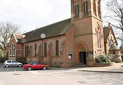
 Church of St.John the Evangelist, Mortimer | |
| Location | |
| Grid reference: | SU6565 |
| Location: | 51°22’37"N, 1°3’47"W |
| Data | |
| Population: | 5,089 (2001) |
| Post town: | Reading |
| Postcode: | RG7 |
| Dialling code: | 0118 |
| Local Government | |
| Council: | West Berkshire |
| Parliamentary constituency: |
Wokingham |
Mortimer Common, generally referred to as Mortimer, is a village in Berkshire, in the south of the county close to the Hampshire border. It lies seven miles southwest of Reading.
History and Name
The name of the village appears to derive from the powerful mediæval family of Mortimer, who were Lords of the Manor here. The Mortimer family, who became Earls of March, are for famous for their power base in the Welsh Marches, in particular Wigmore in Herefordshire. The family’s downfall came when Edward III came of age and executed his mother’s lover, Roger de Mortimer, who had overthrown and slain King Edward II and for three years been de facto ruler of England. At Mortimer’s execution in 1330, his lands were forfeit, and so the village of Mortimer fell to the Crown.
During the Tudor period Mortimer was one of the lands granted to each of the wives of King Henry VIII.
There are several Bronze Age burial mounds in the area. Anglo-Saxon burials have been found also.
About the village
Mortimer has three village halls (The Community Hall, St John's and the Methodist Hall), a surgery, a chemist, a dentist, a bank, a library, a post office, a fire station and a community police station.
The village has a good range of local shops, a Chinese take away, an Indian restaurant, a café, and two estate agencies.
Mortimer has three public houses: The Victoria Arms, The Turners Arms and The Horse and Groom.

Mortimer stands at the top of Mortimer Hill, at the bottom of which is Stratfield Mortimer. To the north lie Burghfield Common and Wokefield. To the west are Mortimer West End and Padworth Common.
The Lockram Brook flows through the middle of the parish and joins into Burghfield Brook further to the northeast. This in turn feeds into Foudry Brook, which has been diverted to feed the Kennet and Avon Canal. There is much woodland in the area, including Starvale Woods, Wokefield Common and Holden Firs.
Churches
- Church of England:
- St John the Evangelist (Mortimer Common)
- St Mary the Virgin (Stratfield Mortimer)
- St Saviours (Mortimer West End)
- Methodist: Mortimer Methodist
Next to St John's church is St John's Infant School. Next to St Mary's church is St Mary's School.
Sport and leisure
- Football:
- Mortimer FC
- Junior teams:
- Mortimer Stingers
- Mortimer Hornets.
- Cricket
- Tennis
Big Society
- Cubs, scouts, girl guides and brownies
- The Mortimer Dramatic Society.
- MortimerMusicLIVE, an organisation to promote and host life music in the village.
A community centre was completed in the autumn of 2009, which is used as a cricket pavilion. The fairground is also used for travelling funfairs.
An annual fun run takes place on the last Sunday of September; a 10 kilometre race around the village.
Outside links
| ("Wikimedia Commons" has material about Mortimer Common) |
- MortimerMusic LIVE -varied local and live Music for Mortimer and Burghfield
- Victoria Arms Reserves FC
- Mortimer Hornets FC
- Mortimer Dramatic Society
- Mortimer Village Website
- Royal Berkshire History: Stratfield Mortimer
