Difference between revisions of "Maxton"
(Created page with "{{county|Roxburghshire}} '''Maxton''' is a hamlet and parish in Roxburghshire. It lies just off the A68 road, south of St Boswells, north of Ancrum, and east of ...") |
|||
| Line 1: | Line 1: | ||
{{county|Roxburghshire}} | {{county|Roxburghshire}} | ||
| − | '''Maxton''' is a hamlet and parish in [[Roxburghshire]]. It lies just off the A68 road, south of [[St Boswells]], north of [[Ancrum]], and east of [[Newtown St Boswells]] | + | '''Maxton''' is a hamlet and parish in [[Roxburghshire]] adjacent to [[River Tweed]] which for the most part here forms the border with [[Berwickshire]]. It lies just off the A68 road, south of [[St Boswells]], north of [[Ancrum]], and east of [[Newtown St Boswells]]. Adjacent parishes are [[Mertoun]] (in Berwickshire) to the north; [[Makerstoun]] to the north-east; [[Roxburgh]] to the east and south-east; Ancrum to the south-west; and St Boswells to the west. |
Maxton is situated on the [[St Cuthbert's Way]] long-distance footpath. | Maxton is situated on the [[St Cuthbert's Way]] long-distance footpath. | ||
| Line 22: | Line 22: | ||
==Outside links== | ==Outside links== | ||
| + | *Location map: {{wmap|55.563|-2.6151|zoom=14}} | ||
*[http://canmore.rcahms.gov.uk/en/site/110540/details/maxton/ RCAHMS/Canmore record for Maxton] | *[http://canmore.rcahms.gov.uk/en/site/110540/details/maxton/ RCAHMS/Canmore record for Maxton] | ||
*[http://www.scotlandsplaces.gov.uk/search/index.php?page=01&p_type=PARISH&p_name=maxton&p_county=Roxburghshire&id=1092&cache_name=111parishmaxton1092 RCAHMS record for the former parish of Maxton] | *[http://www.scotlandsplaces.gov.uk/search/index.php?page=01&p_type=PARISH&p_name=maxton&p_county=Roxburghshire&id=1092&cache_name=111parishmaxton1092 RCAHMS record for the former parish of Maxton] | ||
| − | |||
[[Category:Towns and villages in Roxburghshire]] | [[Category:Towns and villages in Roxburghshire]] | ||
Latest revision as of 18:33, 14 May 2016
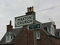
Maxton is a hamlet and parish in Roxburghshire adjacent to River Tweed which for the most part here forms the border with Berwickshire. It lies just off the A68 road, south of St Boswells, north of Ancrum, and east of Newtown St Boswells. Adjacent parishes are Mertoun (in Berwickshire) to the north; Makerstoun to the north-east; Roxburgh to the east and south-east; Ancrum to the south-west; and St Boswells to the west.
Maxton is situated on the St Cuthbert's Way long-distance footpath.
Contents
History
Walter Stewart, 6th High Steward of Scotland, made a charter to John St Clair, his valet, of the lands of Maxton, Roxburghshire, circa 1320/1326, one of the witnesses being "Roberto de Lauwedir (Robert de Lauder) tunc justiciario Laudonie" (Justiciar of Lothian).[1]
A Retour dated March 31, 1670, is recorded whereby Elizabeth and Anna Scott were served heirs to their father George Scott, brother-German to Sir Walter Scott of Whitslaid, Selkirkshire, in the barony of Maxtoun etc. the barony of Dolphingstoune and Falla, lands of Morebattle and Cowbog, etc., all united into the barony of Maxtoun by Charter granted to Sir John Ker of Jedburgh, knight, and John Ker of Longnewton, his son, under the Great Seal of Scotland (of which clearly the Kers have some time parted). Also the barony of Lyntoun, lands and lordship of Jedburgh, etc.[2]
Gallery
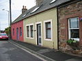
Cottages in Maxton
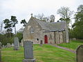
Maxton Church
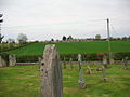
Village field and lane
St. Cuthbert's Way


