Chipping, Hertfordshire: Difference between revisions
Jump to navigation
Jump to search
Created page with "{{Infobox town |name=Chipping |county=Hertfordshire |picture='The Countryman' inn, Chipping, Herts. - geograph.org.uk - 261501.jpg |picture caption='The Countryman', Chipping ..." |
mNo edit summary |
||
| Line 10: | Line 10: | ||
|LG district=East Hertfordshire | |LG district=East Hertfordshire | ||
}} | }} | ||
'''Chipping''' is a small village in [[Hertfordshire]], on the A10 road and sharing a parish with nearby [[Buckland]] ("Buckland and Chipping"). | '''Chipping''' is a small village in [[Hertfordshire]], on the A10 road and sharing a parish with nearby [[Buckland, Hertfordshire|Buckland]] ("Buckland and Chipping"). | ||
The village is spread along the A10, the [[Old North Road]] running south-north between London and Cambridge, and which was the Roman [[Ermine Street]]. The 'great house' is Chipping Hall. There is a single pub, The Countryman. | The village is spread along the A10, the [[Old North Road]] running south-north between London and Cambridge, and which was the Roman [[Ermine Street]]. The 'great house' is Chipping Hall. There is a single pub, The Countryman. | ||
Latest revision as of 22:21, 8 October 2014
| Chipping | |
| Hertfordshire | |
|---|---|
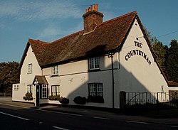
 'The Countryman', Chipping | |
| Location | |
| Grid reference: | TL355320 |
| Location: | 51°58’12"N, 0°1’39"W |
| Data | |
| Postcode: | SG9 |
| Local Government | |
| Council: | East Hertfordshire |
Chipping is a small village in Hertfordshire, on the A10 road and sharing a parish with nearby Buckland ("Buckland and Chipping").
The village is spread along the A10, the Old North Road running south-north between London and Cambridge, and which was the Roman Ermine Street. The 'great house' is Chipping Hall. There is a single pub, The Countryman.