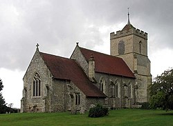
Buckland, Hertfordshire
| Buckland | |
| Hertfordshire | |
|---|---|
 St Andrew, Buckland | |
| Location | |
| Grid reference: | TL356338 |
| Location: | 51°59’11"N, 0°1’36"W |
| Data | |
| Postcode: | SG9 |
| Local Government | |
| Council: | East Hertfordshire |
Buckland is a village in north-eastern Hertfordshire. It stands on the A10 trunk road; the old Roman Ermine Street which runs due north-south here, where the road crosses the chalk uplands between Buntingford and Royston.
To the south on the road is the equally small village of Chipping, with which it forms a joint civil parish. To the north is Reed. According to the 2001 census, Buckland had just 285 souls.
The village is found about 4½ miles south of Royston on the A10 trunk road, and about 2½ miles north of Buntingford.
The parish church is St Andrew stands at the highest point away form the road. It is a fine 14th-century church with Victorian stained glass showing scenes from the New Testament. Carved stone angels play instruments. The church possesses, in addition to those graven harps and horns, a beautifully decorated organ.
Outside links

| ("Wikimedia Commons" has material about Buckland, Hertfordshire) |
This Hertfordshire article is a stub: help to improve Wikishire by building it up.