Bothwell Water: Difference between revisions
Jump to navigation
Jump to search
Created page with "right|thumb|300px|The Bothwell Water {{county|Berwickshire}} The '''Bothwell Water''' is a river in Berwickshire. I..." |
|||
| (One intermediate revision by the same user not shown) | |||
| Line 1: | Line 1: | ||
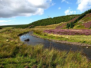
[[File:Bothwell Water - geograph.org.uk - | [[File:Bothwell Water, Lammermuirs - geograph.org.uk - 226985.jpg|right|thumb|300px|The Bothwell Water on Lammermuir]] | ||
{{county|Berwickshire}} | {{county|Berwickshire}} | ||
The '''Bothwell Water''' is a river in [[Berwickshire]]. It has but a short life on [[Lammermuir]]; it rises in the hills near [[Caldercleugh]] and continues past the [[Upper Monynut Forest]], [[Crichness]], [[Bothwell Hill]], and the village of [[Bothwell]]. | The '''Bothwell Water''' is a river in [[Berwickshire]]. It has but a short life on [[Lammermuir]]; it rises in the hills near [[Caldercleugh]] and continues past the [[Upper Monynut Forest]], [[Crichness]], [[Bothwell Hill]], and the village of [[Bothwell]]. | ||
| Line 6: | Line 6: | ||
==Outside links== | ==Outside links== | ||
* | *Location map: {{wmap|55.884319|-2.513359|zoom=14}} | ||
*OS map: {{map|NT679658}} | |||
*[http://www.jstor.org/pss/2257189 The Soils and Vegetation of Lammermuir] | *[http://www.jstor.org/pss/2257189 The Soils and Vegetation of Lammermuir] | ||
[[Category:Rivers of Berwickshire]] | [[Category:Rivers of Berwickshire]] | ||
Latest revision as of 21:12, 1 November 2016

The Bothwell Water is a river in Berwickshire. It has but a short life on Lammermuir; it rises in the hills near Caldercleugh and continues past the Upper Monynut Forest, Crichness, Bothwell Hill, and the village of Bothwell.
At Bothwell, still in the hills, the Bothwell Water joins the Whiteadder Water.
Outside links
- Location map: 55°53’4"N, 2°30’48"W
- OS map: NT679658
- The Soils and Vegetation of Lammermuir