Clynderwen: Difference between revisions
Created page with '{{Infobox town | name = Clynderwen | county = Carmarthenshire | picture = Castelldwyran Church, Clynderwen - geograph.org.uk - 579647.jpg | picture caption= Castelldwyran Church,…' |
No edit summary |
||
| (2 intermediate revisions by the same user not shown) | |||
| Line 1: | Line 1: | ||
{{Infobox town | {{Infobox town | ||
| name = Clynderwen | | name = Clynderwen | ||
| county = Carmarthenshire | | county 1= Carmarthenshire | ||
| county 2= Pembrokeshire | |||
| picture = Castelldwyran Church, Clynderwen - geograph.org.uk - 579647.jpg | | picture = Castelldwyran Church, Clynderwen - geograph.org.uk - 579647.jpg | ||
| picture caption= Castelldwyran Church, Clynderwen | | picture caption= Castelldwyran Church, Clynderwen | ||
| os grid ref = SN133198 | | os grid ref = SN133198 | ||
| latitude = 51.84550 | | latitude = 51.84550 | ||
| longitude = 4.71181 | | longitude = -4.71181 | ||
| post town = Clynderwen | | post town = Clynderwen | ||
| postcode = SA66 | | postcode = SA66 | ||
| dialling code = | | dialling code =01437 | ||
| LG district = Pembrokeshire | | LG district = Pembrokeshire | ||
| constituency = | | constituency = | ||
| Line 16: | Line 17: | ||
==History== | ==History== | ||
The village is | The village is the A478 road adjacent to the [[Preseli Hills]] (where the stones for [[Stonehenge]] were quarried) and owes its more recent origins to the advent of the railways in the 19th century. The Great Western Railway line from [[London]] to the ports of [[Milford Haven]], [[Neyland]] and [[Fishguard]] passes through the village and a rail junction for the original line to Fishguard existed until the 1950s. | ||
As the railways expanded, they became instrumental in the development of local economies and Clynderwen became a point where agricultural produce, livestock, etc. were transhipped. A small hotel was built next to the railway station and, for the next one hundred or so years, the village gently expanded. Nowadays it is within easy commuting distance of the nearby towns, but its function as a centre of the local agricultural community has long since ceased. | As the railways expanded, they became instrumental in the development of local economies and Clynderwen became a point where agricultural produce, livestock, etc. were transhipped. A small hotel was built next to the railway station and, for the next one hundred or so years, the village gently expanded. Nowadays it is within easy commuting distance of the nearby towns, but its function as a centre of the local agricultural community has long since ceased. | ||
Clunderwen railway station is situated on the | Clunderwen railway station is situated between [[Whitland]] and [[Clarbeston Road]]. It lies exactly on the county border, and due to the staggered nature of the platforms, the westbound platform is in Carmarthenshire, while the eastbound is in Pembrokeshire. | ||
[[Category:Towns and villages in Carmarthenshire]] | [[Category:Towns and villages in Carmarthenshire]] | ||
Latest revision as of 13:13, 30 November 2022
| Clynderwen | |
| Carmarthenshire, Pembrokeshire | |
|---|---|
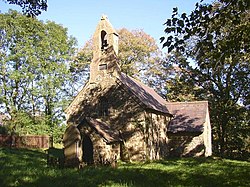
 Castelldwyran Church, Clynderwen | |
| Location | |
| Grid reference: | SN133198 |
| Location: | 51°50’44"N, 4°42’43"W |
| Data | |
| Post town: | Clynderwen |
| Postcode: | SA66 |
| Dialling code: | 01437 |
| Local Government | |
| Council: | Pembrokeshire |
Clynderwen is a rural village on the Carmarthenshire/Pembrokeshire border. The village is known as a camping destination and is popular for self-catering holidays. It has its own community council of 10 members.
History
The village is the A478 road adjacent to the Preseli Hills (where the stones for Stonehenge were quarried) and owes its more recent origins to the advent of the railways in the 19th century. The Great Western Railway line from London to the ports of Milford Haven, Neyland and Fishguard passes through the village and a rail junction for the original line to Fishguard existed until the 1950s.
As the railways expanded, they became instrumental in the development of local economies and Clynderwen became a point where agricultural produce, livestock, etc. were transhipped. A small hotel was built next to the railway station and, for the next one hundred or so years, the village gently expanded. Nowadays it is within easy commuting distance of the nearby towns, but its function as a centre of the local agricultural community has long since ceased.
Clunderwen railway station is situated between Whitland and Clarbeston Road. It lies exactly on the county border, and due to the staggered nature of the platforms, the westbound platform is in Carmarthenshire, while the eastbound is in Pembrokeshire.