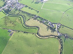
Ballymagorry: Difference between revisions
Created page with '{{Infobox town |name=Ballymagorry |county=Tyrone |picture= |picture caption= |os grid ref=C3501 |LG district=Strabane }} '''Ballymagorry''' is a village in Tyrone. {{stub}}' |
No edit summary |
||
| Line 2: | Line 2: | ||
|name=Ballymagorry | |name=Ballymagorry | ||
|county=Tyrone | |county=Tyrone | ||
|picture= | |picture=Ballymagorry - geograph.org.uk - 306284.jpg | ||
|picture caption= | |picture caption=Ballymagorry | ||
|os grid ref= | |os grid ref=C367013 | ||
|latitude=54.858025 | |||
|longitude=-7.429827 | |||
|population= | |||
|census year= | |||
|post town= | |||
|postcode=BT82 | |||
|dialling code=028 | |||
|townland=yes | |||
|LG district=Strabane | |LG district=Strabane | ||
|constituency= | |||
}} | }} | ||
'''Ballymagorry''' is a village in [[Tyrone]]. | '''Ballymagorry''' or '''Ballymagory''' is a small village and townland on the [[River Glenmornan]] in [[Tyrone]]. It is to the west of [[Artigarvan]] and five miles north of [[Strabane]]. The village is on the main A5 trunk road between Strabane and [[Londonderry]]. To the west if the [[River Foyle]], marking the border of [[County Donegal]] and the Irish Republic. | ||
{{ | The 2001 Census recorded a population of 565. | ||
[[File:St Patricks Church, Ballymagorry, May 2010 (28).JPG|right|thumb|200px|St Patrick's Church]] | |||
The name of the village is from the Gaelic ''Baile Mhic Gofraidh'', meaning 'MacGorry's townland'<ref>{{placenamesNI|1136|Ballymagorry}}</ref> The village is known as ''Bellymagarry'' in Ulster-Scots. It is in the Barony of [[Strabane Lower]]. The townland covers 289 acres. | |||
==Transport== | |||
The area was once served by rail with Ballymagorry railway station run by the County Donegal Railway on the section from Strabane (CDR) railway station to [[Londonderry]] Victoria Road. Ballymagorry station opened on 7 August 1900 but was shut on 1 January 1955.<ref>{{cite web | title=Ballymagorry station | work=Railscot - Irish Railways | url=http://www.railscot.co.uk/Ireland/Irish_railways.pdf |format=PDF| access-date=2007-09-11| archive-url=https://web.archive.org/web/20070926042407/http://www.railscot.co.uk/Ireland/Irish_railways.pdf| archive-date=26 September 2007 | url-status=live}}</ref> | |||
==Sport== | |||
*Cricket: Fox Lodge Cricket Club | |||
==Outside links== | |||
*[http://freepages.genealogy.rootsweb.com/~cotyroneireland/rental/ballymagorry.html Ballymagorry Rent Rolls] | |||
==References== | |||
{{commons}} | |||
{{reflist}} | |||
Latest revision as of 13:50, 28 November 2022
| Ballymagorry | |
| Tyrone | |
|---|---|
 Ballymagorry | |
| Location | |
| Grid reference: | C367013 |
| Location: | 54°51’29"N, 7°25’47"W |
| Data | |
| Postcode: | BT82 |
| Dialling code: | 028 |
| Local Government | |
| Council: | Derry and Strabane |
Ballymagorry or Ballymagory is a small village and townland on the River Glenmornan in Tyrone. It is to the west of Artigarvan and five miles north of Strabane. The village is on the main A5 trunk road between Strabane and Londonderry. To the west if the River Foyle, marking the border of County Donegal and the Irish Republic.
The 2001 Census recorded a population of 565.

The name of the village is from the Gaelic Baile Mhic Gofraidh, meaning 'MacGorry's townland'[1] The village is known as Bellymagarry in Ulster-Scots. It is in the Barony of Strabane Lower. The townland covers 289 acres.
Transport
The area was once served by rail with Ballymagorry railway station run by the County Donegal Railway on the section from Strabane (CDR) railway station to Londonderry Victoria Road. Ballymagorry station opened on 7 August 1900 but was shut on 1 January 1955.[2]
Sport
- Cricket: Fox Lodge Cricket Club
Outside links
References
| ("Wikimedia Commons" has material about Ballymagorry) |
- ↑ Ballymagorry - Placenames NI
- ↑ "Ballymagorry station" (PDF). Railscot - Irish Railways. http://www.railscot.co.uk/Ireland/Irish_railways.pdf.
