Tees Barrage: Difference between revisions
Created page with "{{Infobox bridge |name=Tees Barrage |county 1=Durham |county 2=Yorkshire |picture=Tees_barrage-2008.jpg |picture caption=The Tees barrage, bridge and footbridge |os grid ref=N..." |
No edit summary |
||
| Line 1: | Line 1: | ||
{{Infobox bridge | {{Infobox bridge | ||
|name=Tees Barrage | |name=Tees Barrage | ||
|county | |county=Durham | ||
|picture=Tees_barrage-2008.jpg | |picture=Tees_barrage-2008.jpg | ||
|picture caption=The Tees barrage, bridge and footbridge | |picture caption=The Tees barrage, bridge and footbridge | ||
| Line 22: | Line 21: | ||
|website=[https://canalrivertrust.org.uk/places-to-visit/tees-barrage-and-stockton Tees Barrage] | |website=[https://canalrivertrust.org.uk/places-to-visit/tees-barrage-and-stockton Tees Barrage] | ||
}} | }} | ||
The '''Tees Barrage''' is a barrage and road bridge across the [[River Tees]] | The '''Tees Barrage''' is a barrage and road bridge across the [[River Tees]] at [[Stockton-on-Tees]] in [[County Durham]]. The barrage crosses the 'New Cut' of the Tees, which bypassed the Mandale Loop of the river, and thus is entirely in County Durham. | ||
The barrage is just upriver of Blue House Point and is used to control the flow of the river, preventing flooding and the effects of tidal change. It also provides road access southward, with limited road access to the north bank. | The barrage is just upriver of Blue House Point and is used to control the flow of the river, preventing flooding and the effects of tidal change. It also provides road access southward, with limited road access to the north bank. | ||
| Line 100: | Line 99: | ||
[[Category:Locks in County Durham]] | [[Category:Locks in County Durham]] | ||
Latest revision as of 18:12, 7 September 2024
| Tees Barrage | |
| County Durham | |
|---|---|
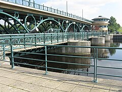 The Tees barrage, bridge and footbridge | |
| Location | |
| Crossing: | River Tees |
| Location | |
| Grid reference: | NZ46251904 |
| Location: | 54°33’52"N, 1°17’10"W |
| Structure | |
| Length: | 525 feet Main span: 25 feet |
| Material: | Concrete, welded tubular steel and plate steel |
| History | |
| Built 1995 | |
| Information | |
| Website: | Tees Barrage |
The Tees Barrage is a barrage and road bridge across the River Tees at Stockton-on-Tees in County Durham. The barrage crosses the 'New Cut' of the Tees, which bypassed the Mandale Loop of the river, and thus is entirely in County Durham.
The barrage is just upriver of Blue House Point and is used to control the flow of the river, preventing flooding and the effects of tidal change. It also provides road access southward, with limited road access to the north bank.
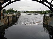
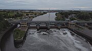
The Tees Barrage comprises a river barrage, road bridge, footbridge, barge lock, fish pass and access point to a white water course. The waters above the barrage are permanently held at the level of an average high tide and are used for watersports such as canoeing, jet skiing, dragonboat racing and incorporates a half-mile rowing course.
The Tees Barrage and Tees Barrage International White Water Course were developed by the defunct Teesside Development Corporation.
Design
The concrete base of the barrage is 230 feet wide, 105 feet long, and 16 feet thick; it is supported by five concrete piers. In between the piers are four 26-foot tall, 50-ton fish belly plates to control the flow of water, operated by 21 ton hydraulic rams.
The road bridge, weighing 600 tons, is of a tubular steel arched viaduct design specified at 45 units of HB motorway loading.
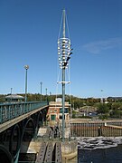
On the downstream side of the central pier is a 95-foot tower of lights with reflective globes and plates, supported by guy ropes. Illumination is provided by four lights on the concrete barrage base for ease of maintenance.
The project included the regeneration of 247 acres of adjacent derelict land producing riverside walks, parkland and leisure facilities.
Operation
The barrage was opened on 22 April 1995, with an international competition on the white water course, and inaugurated on 17 July the same year by Prince Philip, Duke of Edinburgh.
In April 2001 ownership of the Tees Barrage and white water course was passed to British Waterways (now the Canal & River Trust).[1] The Canal & River Trust are also responsible for managing the 11 miles of navigable grade A two star waters of the river Tees from the barrage up to the Low Moor Weir at Low Worsall beyond Yarm. Operation of the river below the barrage is the responsibility of the Tees and Hartlepool Port Authority.
Large quantities of natural debris such as branches are being washed down and caught by the barrage that otherwise would have been taken out to sea, and there are ongoing studies looking into the feasibility of burning this debris for power generation in waste-to-energy power stations.[2]
Barge Lock
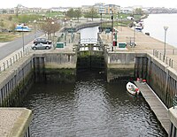
The lock is a single-rise lock with two pairs of lock gates to allow light river traffic to negotiate the barrage.
The dimensions of the lock are length 82 feet, beam 20 feet, height 18 feet, with a draught of 8 feet. If necessary, when the lock is in use, a single leaf steel bascule lifting bridge over the lock is raised to allow the passage of lock traffic.
There is no charge to use the lock however users must have permits to use the river both above and below the barrage.
Tidal Turbine Test Facility
On 8 June 2007 a new facility was opened for testing prototype marine current turbines and other turbine devices. This facility is operated and funded by the National Renewable Energy Centre.
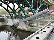
The facility uses the hydraulic head in the barge lock to release water through sluices at a controlled velocity to create a simulation of steady ocean current conditions downstream of the lock.
The first turbine to be tested at this site was Evopod, a semi submerged floating tidal turbine developed by offshore consultancy Ocean Flow Energy Ltd based in North Shields.
The test was largely a success and further devices are booked including a Rugged Renewables Savonius rotor that is to be deployed as a building-mounted turbine.
Footbridge
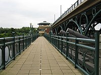
A steel footbridge carries walkers and cyclists across the concrete piers of the barrage on the Teesdale Way, part of the National Cycle Network.
The footbridge consists of two parts, a steel footbridge across the concrete piers and a hydraulically operated single-leaf steel bascule across the lock to allow river craft to pass.
Fish pass
To allow migratory salmon and sea trout to negotiate the barrage a fish pass with fish counter and viewing area is installed next to the north bank pavilion.[3] Some angling groups argue that the progress of migratory fish is delayed below the barrier as fish have difficulty finding the very narrow entrance to the fish pass and that excessive numbers of foraging seals are taking advantage of this delay and are predating these fish and thus damaging the recovery of salmonids on the Tees.[4]
Starting in April 2008 British Waterways commissioned a three-year electronic fish tagging survey to help understand the interactions and relationships between various wildlife at the barrage focusing on seal numbers and salmonid migration.[1]
Pictures
| ("Wikimedia Commons" has material about Tees Barrage) |
Outside links
- The Tees Barrage
- Tees Barrage: Bridges on the Tyne
- Tees Barrage Bridge at Structurae
- Tees Footbridge at Structurae
- Tees Barrage at Structurae
References
- ↑ 1.0 1.1 "Enough is enough – ACA demands new fish pass for the Tees Barrage". Martin James. http://news.bfhosting.co.uk/cgi-bin/news/news.cgi?article=642&vf=true&site=mjfishing.
- ↑ "Plan for barrage power generation". BBC News. BBC. 2 November 2005. http://news.bbc.co.uk/1/hi/england/tees/4398736.stm.
- ↑ Lloyd, Mark (24 December 2006). "Salmonid migration". Angling News. http://www.anglingnews.net/rep_detail.asp?ID=7085.
- ↑ "Barrage 'threat to fish stocks'". BBC News. 20 December 2006. http://news.bbc.co.uk/1/hi/england/tees/6195785.stm.
| Bridges and crossings on the River Tees | ||||||
|---|---|---|---|---|---|---|
| Millennium Footbridge | Princess of Wales Bridge | Infinity Bridge | Tees Barrage | Tees Viaduct | Newport Bridge | Transporter Bridge |


