Lissington: Difference between revisions
Created page with '{{Infobox town |name=Lissington |county=Lincolnshire |picture= |picture caption= |os grid ref=TF108833 |latitude=53.335302 |longitude=-0.336293 |postcode=LN3 |dialling code= |pop…' |
No edit summary |
||
| Line 2: | Line 2: | ||
|name=Lissington | |name=Lissington | ||
|county=Lincolnshire | |county=Lincolnshire | ||
|picture= | |picture=St.John the Baptist's church, Lissington, Lincs. - geograph.org.uk - 73340.jpg | ||
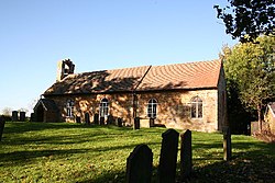
|picture caption= | |picture caption=Parish church of St John the Baptist | ||
|os grid ref=TF108833 | |os grid ref=TF108833 | ||
|latitude=53.335302 | |latitude=53.335302 | ||
| Line 15: | Line 15: | ||
|constituency=Gainsborough | |constituency=Gainsborough | ||
}} | }} | ||
'''Lissington''' is a village in [[Lincolnshire]], | '''Lissington''' is a village and parish in [[Lincolnshire]], four miles south of the town of [[Market Rasen]], and about the same distance north of [[Wragby]]. | ||
Lissington is listed in the 1086 [[Domesday Book]] of 1086 as ''Lessintone''. It is recorded as having 28 households, and 80 acres of meadow and 80 of woodland.<ref>{{cite web|title=Domesday Map|url=http://www.domesdaymap.co.uk/place/TF1083/lissington/|work=Lissington|publisher=Anna Powell-Smith/University of Hull|accessdate=21 June 2011}}</ref> | Lissington is listed in the 1086 [[Domesday Book]] of 1086 as ''Lessintone''. It is recorded as having 28 households, and 80 acres of meadow and 80 of woodland.<ref>{{cite web|title=Domesday Map|url=http://www.domesdaymap.co.uk/place/TF1083/lissington/|work=Lissington|publisher=Anna Powell-Smith/University of Hull|accessdate=21 June 2011}}</ref> | ||
The village is in [[Lindsey]], the northern [[Parts of Lincolnshire|part of Lincolnshire]], and the three Ridings of Lindsey meet | The village is in [[Lindsey]], the northern [[Parts of Lincolnshire|part of Lincolnshire]], and the three Ridings of Lindsey meet just to the north-west of Lissington. The parish itself lies in the [[South Riding of Lindsey|South Riding]] ([[Wraggoe Wapentake]]). | ||
==Parish church== | ==Parish church== | ||
The parish church, dedicated to Saint John the Baptist, is a Grade II listed building built from ironstone and greenstone. It dates from 1796, with a restoration in 1895 and further additions in 1925.<ref>{{cite web|title=British Listed Buildings|url=http://www.britishlistedbuildings.co.uk/en-197144-church-of-st-john-the-baptist-lissington|work=St John the Baptist Church, Lissington|publisher=English Heritage|accessdate=21 June 2011}}</ref> | The parish church, dedicated to Saint John the Baptist, is a Grade II listed building built from ironstone and greenstone. It dates from 1796, with a restoration in 1895 and further additions in 1925.<ref>{{cite web|title=British Listed Buildings|url=http://www.britishlistedbuildings.co.uk/en-197144-church-of-st-john-the-baptist-lissington|work=St John the Baptist Church, Lissington|publisher=English Heritage|accessdate=21 June 2011}}</ref> | ||
Lissington Church of England School was built in 1854 as a National school and closed 21 December 1950. | Lissington Church of England School was built in 1854 as a National school and closed 21 December 1950. | ||
==Outside links== | ==Outside links== | ||
==References== | ==References== | ||
{{reflist}} | {{reflist}} | ||
Latest revision as of 13:05, 10 May 2024
| Lissington | |
| Lincolnshire | |
|---|---|
 Parish church of St John the Baptist | |
| Location | |
| Grid reference: | TF108833 |
| Location: | 53°20’7"N, 0°20’11"W |
| Data | |
| Population: | 138 (2001) |
| Post town: | Lincoln |
| Postcode: | LN3 |
| Local Government | |
| Council: | West Lindsey |
| Parliamentary constituency: |
Gainsborough |
Lissington is a village and parish in Lincolnshire, four miles south of the town of Market Rasen, and about the same distance north of Wragby.
Lissington is listed in the 1086 Domesday Book of 1086 as Lessintone. It is recorded as having 28 households, and 80 acres of meadow and 80 of woodland.[1]
The village is in Lindsey, the northern part of Lincolnshire, and the three Ridings of Lindsey meet just to the north-west of Lissington. The parish itself lies in the South Riding (Wraggoe Wapentake).
Parish church
The parish church, dedicated to Saint John the Baptist, is a Grade II listed building built from ironstone and greenstone. It dates from 1796, with a restoration in 1895 and further additions in 1925.[2]
Lissington Church of England School was built in 1854 as a National school and closed 21 December 1950.
Outside links
References
- ↑ "Domesday Map". Lissington. Anna Powell-Smith/University of Hull. http://www.domesdaymap.co.uk/place/TF1083/lissington/. Retrieved 21 June 2011.
- ↑ "British Listed Buildings". St John the Baptist Church, Lissington. English Heritage. http://www.britishlistedbuildings.co.uk/en-197144-church-of-st-john-the-baptist-lissington. Retrieved 21 June 2011.