Diss: Difference between revisions
m clean up, typos fixed: a 16th century → a 16th-century |
No edit summary |
||
| Line 15: | Line 15: | ||
|constituency=South Norfolk | |constituency=South Norfolk | ||
}} | }} | ||
'''Diss''' is a market town in [[Norfolk]], | '''Diss''' is a market town in [[Norfolk]], forming part of the [[Diss Hundred]], on the border with neighbouring [[Suffolk]]. The town lies in the valley of the [[River Waveney]], around a mere that covers six acres. The mere is up to 18 feet deep, although there is another 51 feet of mud. | ||
Diss takes its name from ''dic'', which in Old English may mean either ditch or dyke.<ref>Ekwall, E. (1940) ''The Concise Dictionary of English Place-names''; 2nd ed. Oxford: Clarendon Press; pp. 137, 139</ref> | |||
The town | The town has a large number of historic buildings, including the early 14th century parish church. It is also home to a museum. | ||
Diss railway station lies on the [[Great Eastern Main Line]] route from [[London]] to [[Norwich]]. | |||
Diss railway station lies on the Great Eastern Main Line route from [[London]] to [[Norwich]]. | |||
==Churches== | ==Churches== | ||
Diss has at least | Diss has at least nine churches including [[Church of England]] (St Mary the Virgin), Baptist, Methodist, several community churches and even a Roman Catholic church. | ||
==History== | ==History== | ||
Latest revision as of 16:29, 16 January 2023
| Diss | |
| Norfolk | |
|---|---|
 Diss | |
| Location | |
| Grid reference: | TM1180 |
| Location: | 52°22’52"N, 1°6’28"E |
| Data | |
| Population: | 7,503 (2011) |
| Post town: | Diss |
| Postcode: | IP22 |
| Dialling code: | 01379 |
| Local Government | |
| Council: | South Norfolk |
| Parliamentary constituency: |
South Norfolk |
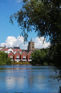
Diss is a market town in Norfolk, forming part of the Diss Hundred, on the border with neighbouring Suffolk. The town lies in the valley of the River Waveney, around a mere that covers six acres. The mere is up to 18 feet deep, although there is another 51 feet of mud.
Diss takes its name from dic, which in Old English may mean either ditch or dyke.[1]
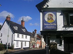
The town has a large number of historic buildings, including the early 14th century parish church. It is also home to a museum.
Diss railway station lies on the Great Eastern Main Line route from London to Norwich.
Churches
Diss has at least nine churches including Church of England (St Mary the Virgin), Baptist, Methodist, several community churches and even a Roman Catholic church.
History
The Domesday Book records that in the days of King Edward the Confessor, which is to say immediately before the Norman Conquest, Diss was a manor in the royal demesne. Domesday records a church and a glebe of 24 acres. This was considered to be worth £15 per annum, which had doubled by the time of William the Conqueror, it being then estimated at £30 with the benefit of the whole hundred and half, belonging to it. It was then found to be a league long, around 3 miles and half this distance broad, and paid 4d. in tax. From this it appears that it was still relatively small, but it grew shortly afterwards when it subsumed Watlingsete Manor, a neighbouring area, which was as large as Diss, and seemingly fuller of inhabitants, according to the geld or tax that it paid.
The whole estate later fell into the hands of the Lordship of the FitzWalters (who were raised to Baron FitzWalters in 1295) and in 1299 the then Lord FitzWalter obtained a charter of confirmation for a fair every year at his manor of Diss, to be held around the feast of Saint Simon and Jude (October 28), and several days after. A grant made in 1298 to William Partekyn of Prilleston (now Billingford) granted, for homage and half a mark of silver, two homesteads in Diss, with liberty of washing his wool and cloths in Diss Meer. This came on the express condition that the gross dye should be washed off first. It seems as if the church of Diss was built by the same Lord, as his arms were cut into the stone of the south porch of the church several times.

Soon after the Battle of Agincourt in 1415, Edward Plantagenet, Duke of York and Earl of Rutland, came to hold Diss manor, hundred, and market, together with Hemenhale; and the title of Lord FitzWalter became attached to the estate. It was part of a much larger estate that included Hemenhale and Diss manors, with the hundred of Diss in Norfolk, the manors of Shimpling and Thorne in Suffolk, of Wodeham-Walter (now Woodham Walter), Henham, Leiden (now part of Leaden Roding), Vitring, Dunmow Parva (Little Dunmow), Burnham (possibly equating to the modern village of Burnham-on-Crouch), Winbush, and Shering (now Sheering) in Essex. Shortly afterwards, the estate was acquired by the Ratcliffe family, who inherited the title of Baron FitzWalter. The Ratcliffe family owned the land until at least 1732, styling themselves Viscounts FitzWalter.
Opposite the 14th century parish church of St. Mary the Virgin stands a 16th-century building known as the Dolphin House. This was one of the most important buildings in the town. Its impressive dressed-oak beams denote it as an important building, possibly a wool merchant's house. Formerly a pub, the Dolphin, from the 1800s to the 1960s, the building now houses a number of small businesses.
Adjacent to Dolphin House is the town's market place, the geographical and social centre of the town. The market is held every Friday (except Good Friday and other holidays, when it is rescheduled to the preceding Thursday): a variety of local traders sell fresh fruit and vegetables, meat, fish and cheeses. The market was first granted a charter by Richard the Lionheart. The town's post office and main shopping street (Mere Street) are also located by the marketplace.
Early in 1871, substantial alterations were made to a house in Mount Street, about 100 yards north of the parish church. The workmen were removing the brick flooring of one of the ground floor rooms and excavating the soil beneath, to insert the joists of a boarded floor, when they discovered a hoard of coins. Beneath the bricks, they came upon the original hard clay floor, and in the centre of the room, at about 18 inches from the surface, the remains of an earthen vessel were found, containing over 300 coins. Except for two fine gold nobles, all of the coins were silver.
In March 2006, Diss became the third town in the United Kingdom to join ‘’Cittaslow’’, an international organisation promoting the concept of 'Slow Towns'.[2]

Sport
- Football: Diss Town FC
- Rugby: Diss RFC (based in nearby Roydon)
- Cycling: Diss & District Cycling Club
- Bowls: Diss & District Bowls Club
- Netball: Diss Ladies’ Netball Club
- Athletics: Diss and District Athletics Club.
Media
- Newspapers:
- The Diss Mercury
- The Diss Express
Outside links
- Diss Town Council – official town council website
- Norfolk: Diss GENUKI Norfolk transcript from History, Gazetteer, and Directory of Norfolk, William White, 1845
References
- ↑ Ekwall, E. (1940) The Concise Dictionary of English Place-names; 2nd ed. Oxford: Clarendon Press; pp. 137, 139
- ↑ Cittaslow, 2006. Diss becomes Cittaslow.
- An Illustrated History & Guide to Diss, by Stephen Govier, published in 2007