Ailsa Craig, South Orkney Islands: Difference between revisions
Jump to navigation
Jump to search
Created page with '{{#vardefine:shire|British Antarctic Territory}} '''Ailsa Craig''' is a precipitous island a mile south of Point Rae, off the south coast of Laurie Island in the [[South …' |
No edit summary |
||
| (2 intermediate revisions by the same user not shown) | |||
| Line 1: | Line 1: | ||
{{ | {{Infobox island | ||
'''Ailsa Craig''' is a precipitous island a mile south of [[Point Rae]], off the south coast of [[Laurie Island]] in the [[South Orkney Islands]] | |name=Ailsa Craig | ||
|territory=British Antarctic Territory | |||
|picture= | |||
|map=Ailsa Craig by Laurie Island - South Orkney Islands, BAT.svg | |||
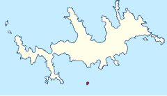
|map caption=Aisa Craig (red) south of Laurie Island | |||
|latitude=-60.783 | |||
|longitude=-44.6 | |||
|group=South Orkney Islands | |||
}} | |||
'''Ailsa Craig''' is a precipitous island a mile south of [[Point Rae]], off the south coast of [[Laurie Island]] in the [[South Orkney Islands]]. | |||
The island was charted in 1903 by the Scottish National Antarctic Expedition under William Speirs Bruce, who named it for [[Ailsa Craig]] in the [[Firth of Clyde]]. | The island was charted in 1903 by the Scottish National Antarctic Expedition under William Speirs Bruce, who named it for [[Ailsa Craig]] in the [[Firth of Clyde]]. | ||
{{ | ==Location== | ||
*Location map: {{wmap|-60.783|-44.6}} | |||
==References== | |||
*{{basgaz|Ailsa Criag}} | |||
{{South Orkneys}} | |||
Latest revision as of 14:44, 21 May 2022
| Ailsa Craig | |
| Location | |
| Location: | 60°46’59"S, 44°36’0"W |
| Data | |
Ailsa Craig is a precipitous island a mile south of Point Rae, off the south coast of Laurie Island in the South Orkney Islands.
The island was charted in 1903 by the Scottish National Antarctic Expedition under William Speirs Bruce, who named it for Ailsa Craig in the Firth of Clyde.
Location
- Location map: 60°46’59"S, 44°36’0"W
References
- Gazetteer and Map of The British Antarctic Territory: Ailsa Criag
